File:PortRoyalEarthquakeMap.jpg
Jump to navigation
Jump to search
Size of this preview: 800 × 572 pixels. Other resolutions: 320 × 229 pixels | 640 × 458 pixels | 948 × 678 pixels.
Original file (948 × 678 pixels, file size: 219 KB, MIME type: image/jpeg)
Captions
Captions
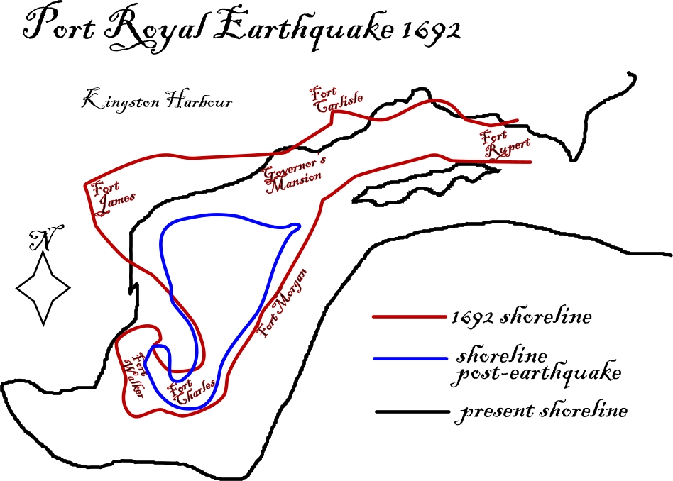
A map displaying the pre-earthquake shoreline, post-earthquake shoreline, and present day shorline location.
Summary[edit]
| Description |
English: Map showing shoreline changes caused by the 1692 Port Royal earthquake |
||
| Date | |||
| Source | Own work, based on information from the The College of Wooster | ||
| Author | I184.147.120.196 | ||
| Permission (Reusing this file) |
|
| Camera location | | View this and other nearby images on: OpenStreetMap |
|---|

|
This geology image could be re-created using vector graphics as an SVG file. This has several advantages; see Commons:Media for cleanup for more information. If an SVG form of this image is available, please upload it and afterwards replace this template with
{{vector version available|new image name}}.
It is recommended to name the SVG file “PortRoyalEarthquakeMap.svg”—then the template Vector version available (or Vva) does not need the new image name parameter. |


File history
Click on a date/time to view the file as it appeared at that time.
| Date/Time | Thumbnail | Dimensions | User | Comment | |
|---|---|---|---|---|---|
| current | 01:24, 11 October 2011 | | 948 × 678 (219 KB) | I184.147.120.196 (talk | contribs) | {{Information |Description ={{en|1=Map showing shoreline changes caused by the 1692 Port Royal earthquake}} |Source ={{own}} |Author =I184.147.120.196 |Date =2011-10-10 |Permission ={{PD-user|I184 |
You cannot overwrite this file.
File usage on Commons
There are no pages that use this file.
File usage on other wikis
The following other wikis use this file:
- Usage on en.wikipedia.org
- Usage on he.wikipedia.org
- Usage on ja.wikipedia.org
- Usage on sr.wikipedia.org
- Usage on uk.wikipedia.org