File:Qendresa 2014-11-08 0143Z VIIRS IR-RBTOP lineless.png
Jump to navigation
Jump to search

Size of this preview: 450 × 600 pixels. Other resolutions: 180 × 240 pixels | 360 × 480 pixels | 576 × 768 pixels | 768 × 1,024 pixels | 1,290 × 1,720 pixels.
Original file (1,290 × 1,720 pixels, file size: 1.19 MB, MIME type: image/png)
Captions
Captions
Add a one-line explanation of what this file represents
Summary[edit]
| Description |
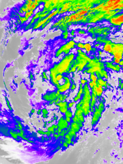
English: The Visible Infrared Imaging Radiometer Suite (VIIRS) on the Suomi NPP satellite acquired this image of a Mediterranean tropical-like cyclone (also known as “Qendresa”) near Sicily around 02:43 CET (01:43 UTC) on 8 November 2014. This image is from the VIIRS “I5” band with the RBTOP enhancements. |
| Date | |
| Source | http://www.class.ngdc.noaa.gov/saa/products/welcome |
| Author | VIIRS imagery from the Suomi NPP satellite operated by the National Oceanic and Atmospheric Administration, converted by “Nasdaq” and optimised by Meow |
| Other versions |
|


| Camera location | | View this and other nearby images on: OpenStreetMap |
|---|
Licensing[edit]
This image is in the public domain because it contains materials that originally came from the U.S. National Oceanic and Atmospheric Administration, taken or made as part of an employee's official duties.
|
File history
Click on a date/time to view the file as it appeared at that time.
| Date/Time | Thumbnail | Dimensions | User | Comment | |
|---|---|---|---|---|---|
| current | 07:06, 27 April 2015 | | 1,290 × 1,720 (1.19 MB) | Meow (talk | contribs) | User created page with UploadWizard |
You cannot overwrite this file.
File usage on Commons
The following 3 pages use this file: