File:Railway Buffers, Downs Link - geograph.org.uk - 1073630.jpg
Jump to navigation
Jump to search

Size of this preview: 449 × 600 pixels. Other resolutions: 179 × 240 pixels | 479 × 640 pixels.
Original file (479 × 640 pixels, file size: 122 KB, MIME type: image/jpeg)
Captions
Captions
Add a one-line explanation of what this file represents
Summary[edit]
| Description |
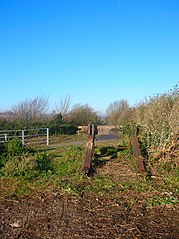
English: Railway Buffers, Downs Link. The rear view of this, 277503 where the vegetation has now been cleared after the extension of the Downs Link path was built between the old Toll Bridge and the Ropetackle development. The Horsham-Shoreham line opened in 1861 and was closed in 1966 except for a small section between Shoreham and Beeding Cement Works that remained open until 1981. |
| Date | |
| Source | From geograph.org.uk |
| Author | Simon Carey |
| Attribution (required by the license) | Simon Carey / Railway Buffers, Downs Link / |
| Camera location | | View this and other nearby images on: OpenStreetMap |
|---|
_heading:292.00&language=en)
| Object location | | View this and other nearby images on: OpenStreetMap |
|---|
_heading:292.00&language=en)
Licensing[edit]

|
This image was taken from the Geograph project collection. See this photograph's page on the Geograph website for the photographer's contact details. The copyright on this image is owned by Simon Carey and is licensed for reuse under the Creative Commons Attribution-ShareAlike 2.0 license.
|
This file is licensed under the Creative Commons Attribution-Share Alike 2.0 Generic license.
Attribution: Simon Carey
- You are free:
- to share – to copy, distribute and transmit the work
- to remix – to adapt the work
- Under the following conditions:
- attribution – You must give appropriate credit, provide a link to the license, and indicate if changes were made. You may do so in any reasonable manner, but not in any way that suggests the licensor endorses you or your use.
- share alike – If you remix, transform, or build upon the material, you must distribute your contributions under the same or compatible license as the original.
File history
Click on a date/time to view the file as it appeared at that time.
| Date/Time | Thumbnail | Dimensions | User | Comment | |
|---|---|---|---|---|---|
| current | 08:09, 24 February 2011 | | 479 × 640 (122 KB) | GeographBot (talk | contribs) | == {{int:filedesc}} == {{Information |description={{en|1=Railway Buffers, Downs Link The rear view of this, 277503 where the vegetation has now been cleared after the extension of the Downs Link path was built between the old Toll Bridge and the Ropet |
You cannot overwrite this file.
File usage on Commons
There are no pages that use this file.