File:Red state, blue state.svg
Jump to navigation
Jump to search

Size of this PNG preview of this SVG file: 800 × 505 pixels. Other resolutions: 320 × 202 pixels | 640 × 404 pixels | 1,024 × 646 pixels | 1,280 × 807 pixels | 2,560 × 1,615 pixels | 940 × 593 pixels.
Original file (SVG file, nominally 940 × 593 pixels, file size: 26 KB)
Captions
Captions
Add a one-line explanation of what this file represents
| Description |
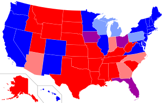
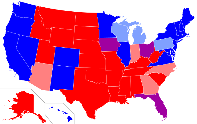
Map of red states and blue states in the U.S. Red=The Republican candidate carried the state in all four most recent presidential elections (2008, 2012, 2016, 2020). Pink=The Republican candidate carried the state in three of the four most recent elections. Purple=The Republican candidate and the Democratic candidate each carried the state in two of the four most recent elections. Light blue=The Democratic candidate carried the state in three of the four most recent elections. Dark blue=The Democratic candidate carried the state in all four most recent elections |
||||||||
| Date | 2008-02-10, updated 2012-11-09, updated 2016-11-09, updated 2020-11-10 | ||||||||
| Source | self-made; base map is Image:Blank US Map.svg | ||||||||
| Author | Angr | ||||||||
| Permission (Reusing this file) |
I, the copyright holder of this work, hereby publish it under the following license:
|
||||||||
| Other versions |
|

.svg)
File history
Click on a date/time to view the file as it appeared at that time.
| Date/Time | Thumbnail | Dimensions | User | Comment | |
|---|---|---|---|---|---|
| current | 01:16, 26 May 2021 | | 940 × 593 (26 KB) | FlagFreak (talk | contribs) | removed empty space on right |
| 13:40, 2 March 2021 |  | 1,020 × 593 (26 KB) | Newfraferz87 (talk | contribs) | Text editable; do not use Inkscape | |
| 06:19, 20 November 2020 |  | 940 × 593 (36 KB) | FlagFreak (talk | contribs) | minor fixes | |
| 06:11, 20 November 2020 |  | 940 × 593 (37 KB) | FlagFreak (talk | contribs) | Updated, now depicts results from 2008 to 2020. Also resized to better fit map. | |
| 18:50, 9 November 2020 |  | 1,020 × 593 (26 KB) | The Image Editor (talk | contribs) | Reverted to version as of 05:15, 13 January 2019 (UTC) | |
| 18:49, 9 November 2020 |  | 1,200 × 900 (322 KB) | The Image Editor (talk | contribs) | Updated map for 2020 election and separated Maine and Nebraska’s second congressional districts | |
| 05:15, 13 January 2019 |  | 1,020 × 593 (26 KB) | Newfraferz87 (talk | contribs) | Move to CSS style for ease of editing | |
| 01:33, 4 May 2017 |  | 959 × 593 (32 KB) | Newfraferz87 (talk | contribs) | Clearer state borders. Update to minimize errors in future file derivations. | |
| 19:26, 10 November 2016 |  | 959 × 593 (32 KB) | Dan Wang (talk | contribs) | Updated for 2016 election (User1937's version had some errors) | |
| 14:28, 9 November 2016 |  | 959 × 593 (1.84 MB) | User1937 (talk | contribs) | 2016 update |
You cannot overwrite this file.
File usage on Commons
The following 10 pages use this file:
- User:Magog the Ogre/Political maps/2016 July 11-20
- User:Magog the Ogre/Political maps/2016 November 1-10
- User:Magog the Ogre/Political maps/2017 May 1-10
- User:Magog the Ogre/Political maps/2019 January 11-20
- User:Magog the Ogre/Political maps/2020 November 1-10
- User:Magog the Ogre/Political maps/2020 November 11-20
- User:Magog the Ogre/Political maps/2021 March 1-10
- User:Magog the Ogre/Political maps/2021 May 21-31
- User:Mahagaja/Gallery
- File:Red and Blue States Map (Average Margins of Presidential Victory).svg
File usage on other wikis
The following other wikis use this file:
- Usage on ar.wikipedia.org
- Usage on bn.wikipedia.org
- Usage on de.wikipedia.org
- Usage on en.wikipedia.org
- Usage on es.wikipedia.org
- Usage on fa.wikipedia.org
- Usage on fr.wikipedia.org
- Usage on fr.wiktionary.org
- Usage on he.wikipedia.org
- Usage on hy.wikipedia.org
- Usage on ja.wikipedia.org
- Usage on ml.wikipedia.org
- Usage on pl.wikipedia.org
- Usage on ro.wikipedia.org
- Usage on simple.wikipedia.org
- Usage on sv.wikipedia.org
- Usage on tr.wikipedia.org
- Usage on uk.wikipedia.org
- Usage on ur.wikipedia.org
- Usage on zh.wikipedia.org