File:Relief Map of Georgia.png
Jump to navigation
Jump to search

Size of this preview: 800 × 426 pixels. Other resolutions: 320 × 170 pixels | 640 × 341 pixels | 1,182 × 629 pixels.
Original file (1,182 × 629 pixels, file size: 1.08 MB, MIME type: image/png)
Captions
Captions
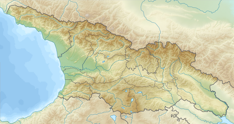
Map relief of Georgia & vicinity.
Summary[edit]
| Description |
English: Relief map of Georgia
Equirectangular projection, N/S stretching 135 %. Geographic limits of the map:
|
| Date | |
| Source |
|
| Author |
|
| Permission (Reusing this file) |
This file is licensed under the Creative Commons Attribution-Share Alike 3.0 Unported license.
|
| Other versions |
|

File history
Click on a date/time to view the file as it appeared at that time.
| Date/Time | Thumbnail | Dimensions | User | Comment | |
|---|---|---|---|---|---|
| current | 20:49, 25 July 2016 | | 1,182 × 629 (1.08 MB) | NordNordWest (talk | contribs) | missing border between Guria and Samegrelo-Zemo Svaneti added |
| 19:22, 26 August 2010 |  | 1,182 × 629 (1.22 MB) | Виктор В (talk | contribs) | =={{int:filedesc}}== {{Information |Description={{en|Relief map of Georgia}} Equirectangular projection, N/S stretching 135 %. Geographic limits of the map: * N: 43.7° N * S: 40.9° N * W: 39.8° E * E: 46.9° E |Source=*[[:File |
You cannot overwrite this file.
File usage on Commons
The following 2 pages use this file:
File usage on other wikis
The following other wikis use this file:
- Usage on als.wikipedia.org
- Usage on ast.wikipedia.org
- Usage on av.wikipedia.org
- Usage on az.wikipedia.org
- Kiçik Qafqaz
- Şablon:Yer xəritəsi Gürcüstan
- Kazbek dağı
- Anaxatır
- Krubera mağarası
- Samsar silsiləsi
- Samsar dağı
- Böyük Əbül dağı
- Kiçik Əbül dağı
- Dəlidağ (Samsar silsiləsi)
- Qori zəlzələsi
- Borjomi-Xaraqauli Milli Parkı
- Yeni Afon mağarası
- Paravani gölü
- Kolxida Milli Parkı
- Laqodexi qoruğu
- Tbilisi su anbarı
- Aktaş gölü
- Mavi göl (Gürcüstan)
- Tiflis Dəmiryol Stansiyası
- Şxara dağı
- Ertso gölü
- Kvedi gölü
- Kvirila çayı
- Dzirula çayı
- Keli gölü
- Raçin silsiləsi
- Kelsk platosu
- Kumistavi mağarası
- Bazaleti gölü
- Tısbağa gölü
- Lisi gölü
- Trialet silsiləsi
- Paleostomi gölü
- Sağamo gölü
- Tabatsğuri gölü
- Kumisi gölü
- Pisunda burnu
- Vaşlovani Milli Parkı
- Mesxeti silsiləsi
- Tsalka su anbarı
- Jinvali su anbarı
- Aşağı Kartli düzənliyi
- Uşba
View more global usage of this file.