File:Rota AirFrance 447 fr-2009-20-07-2.svg
Jump to navigation
Jump to search

Size of this PNG preview of this SVG file: 355 × 532 pixels. Other resolutions: 160 × 240 pixels | 320 × 480 pixels | 512 × 768 pixels | 683 × 1,024 pixels | 1,366 × 2,048 pixels.
Original file (SVG file, nominally 355 × 532 pixels, file size: 51 KB)
Captions
Captions
Add a one-line explanation of what this file represents
| Description |
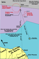
English: Map showing the Air France Flight 447 search area and distances from military bases and control centers of Brazil and Senegal.
Français : Carte décrivant la zone de recherche du crash du vol 447 d'Air France et les distances depuis les centres de contrôle du Brésil et du Sénégal.
Português: Mapa fornecido pela Aeronáutica que mostra a área de buscas e a distância entre as bases militares do país e dos centros de controle de voo do Brasil e do Senegal.
Deutsch: Karte des Suchgebiets nach dem Air France Flug 447 und Distanzen von militärischen Stützpunkten und Kontrollzentren Brasiliens und Senegals. |
| Date | (UTC) |
| Source | |
| Author |
|
| This is a retouched picture, which means that it has been digitally altered from its original version. The original can be viewed here: Rota AirFrance 447 fr-2009-20-07.svg:
|
I, the copyright holder of this work, hereby publish it under the following license:
This file is licensed under the Creative Commons Attribution 2.5 Brazil license.
- You are free:
- to share – to copy, distribute and transmit the work
- to remix – to adapt the work
- Under the following conditions:
- attribution – You must give appropriate credit, provide a link to the license, and indicate if changes were made. You may do so in any reasonable manner, but not in any way that suggests the licensor endorses you or your use.

Original upload log[edit]
This image is a derivative work of the following images:
- File:Rota_AirFrance_447_fr-2009-20-07.svg licensed with Cc-by-2.5-br
- 2009-07-20T05:26:31Z Blogbreather 355x532 (54317 Bytes) {{Information |Description={{en|1=Map showing the Air France Flight 447 search area and distances from military bases and control centers of Brazil and Senegal.}} {{fr|Carte décrivant la zone de recherche du crash du vol 447
Uploaded with derivativeFX
File history
Click on a date/time to view the file as it appeared at that time.
| Date/Time | Thumbnail | Dimensions | User | Comment | |
|---|---|---|---|---|---|
| current | 16:01, 20 July 2009 | | 355 × 532 (51 KB) | Blogbreather (talk | contribs) | {{Information |Description={{en|1=Map showing the Air France Flight 447 search area and distances from military bases and control centers of Brazil and Senegal.}} {{fr|Carte décrivant la zone de recherche du crash du vol 447 d'Air France et les distances |
You cannot overwrite this file.
File usage on Commons
The following page uses this file: