File:Samuel Starkweather Lime Kiln.jpg
Jump to navigation
Jump to search

Size of this preview: 800 × 600 pixels. Other resolutions: 320 × 240 pixels | 640 × 480 pixels | 1,024 × 768 pixels | 1,280 × 960 pixels | 2,560 × 1,920 pixels | 2,816 × 2,112 pixels.
Original file (2,816 × 2,112 pixels, file size: 1.77 MB, MIME type: image/jpeg)
Captions
Captions
Add a one-line explanation of what this file represents
|
This is an image of a place or building that is listed on the National Register of Historic Places in the United States of America. Its reference number is 13001009. |
| Camera location | | View this and other nearby images on: OpenStreetMap |
|---|
| Description |
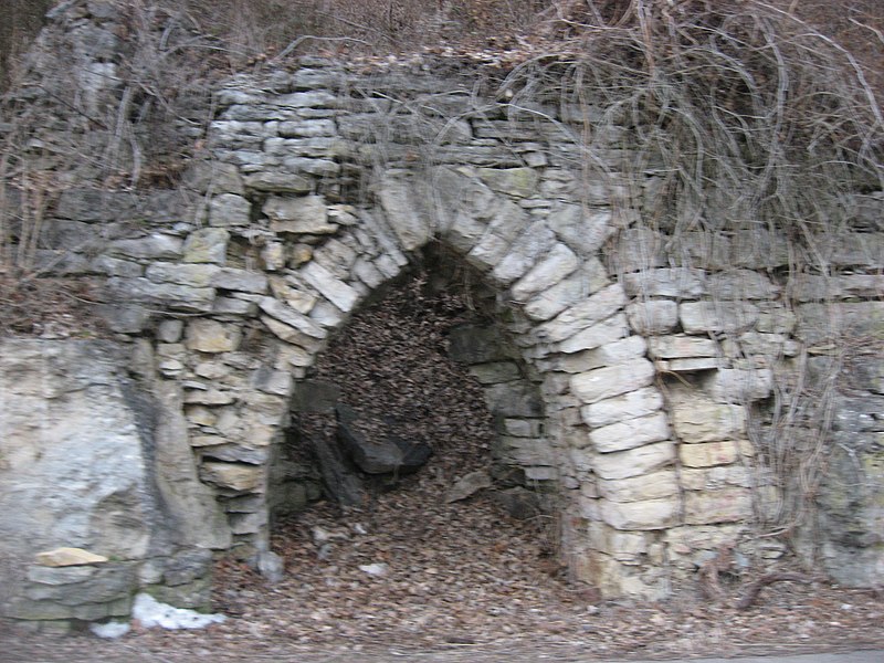
English: Mouth of the Samuel Starkweather Lime Kiln, located along Upper River Road north of Utica in Utica Township, Clark County, Indiana, United States. Established in the early nineteenth century, it is an archaeological site and on the National Register of Historic Places. |
||
| Date | Taken on 1 February 2014 | ||
| Source | Own work | ||
| Author | Nyttend | ||
| Permission (Reusing this file) |
|
File history
Click on a date/time to view the file as it appeared at that time.
| Date/Time | Thumbnail | Dimensions | User | Comment | |
|---|---|---|---|---|---|
| current | 19:28, 2 March 2014 | | 2,816 × 2,112 (1.77 MB) | Nyttend (talk | contribs) | {{NRHP|13001009}} {{Location|38|20|41|N|85|38|52|W}} {{Information |Description={{en|Mouth of the {{w|Samuel Starkweather's Lime Kiln and Quarry|Samuel Starkweather Lime Kiln}}, located along Upper River Road north of {{w|Utica, Indiana|Utica}} in {{w|... |
You cannot overwrite this file.
File usage on Commons
The following page uses this file:
File usage on other wikis
The following other wikis use this file:
Metadata
Categories:
- Archaeological sites in Indiana
- Lime kilns in the United States
- National Register of Historic Places in Clark County, Indiana
- Vaults in the United States
- Industrial structures on the National Register of Historic Places in Indiana
- Views from automobiles in Clark County, Indiana
- Geology of Clark County, Indiana
- Economy of Clark County, Indiana