File:Satirical Europe in 1870.jpg
Jump to navigation
Jump to search

Size of this preview: 800 × 511 pixels. Other resolutions: 320 × 204 pixels | 640 × 409 pixels | 1,119 × 715 pixels.
Original file (1,119 × 715 pixels, file size: 265 KB, MIME type: image/jpeg)
Captions
Captions
Add a one-line explanation of what this file represents
Summary[edit]
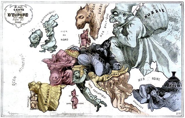
| Paul Hadol: Funny map of Europe for 1870
|
|||||||||||||||||||||||||||
|---|---|---|---|---|---|---|---|---|---|---|---|---|---|---|---|---|---|---|---|---|---|---|---|---|---|---|---|
| Artist |
|
 | |||||||||||||||||||||||||
| Title |
French: Carte drôlatique d’Europe pour 1870 Funny map of Europe for 1870 |
||||||||||||||||||||||||||
| Object type |
print |
||||||||||||||||||||||||||
| Description |
English: A French satirical cartoon map of Europe in 1870 |
||||||||||||||||||||||||||
| Date |
1870 |
||||||||||||||||||||||||||
| Medium |
printing ink on paper |
||||||||||||||||||||||||||
| Source/Photographer | http://strangemaps.wordpress.com/2007/12/23/227/ | ||||||||||||||||||||||||||
| Permission (Reusing this file) |
English: In the public domain because of its age |
||||||||||||||||||||||||||
| Other versions |
|
||||||||||||||||||||||||||
.jpeg)

Licensing[edit]
|
This is a faithful photographic reproduction of a two-dimensional, public domain work of art. The work of art itself is in the public domain for the following reason:
The official position taken by the Wikimedia Foundation is that "faithful reproductions of two-dimensional public domain works of art are public domain".
This photographic reproduction is therefore also considered to be in the public domain in the United States. In other jurisdictions, re-use of this content may be restricted; see Reuse of PD-Art photographs for details. | ||||
File history
Click on a date/time to view the file as it appeared at that time.
| Date/Time | Thumbnail | Dimensions | User | Comment | |
|---|---|---|---|---|---|
| current | 22:25, 30 October 2009 | | 1,119 × 715 (265 KB) | Alex:D (talk | contribs) | bigger, whitened |
| 23:41, 23 December 2007 |  | 600 × 385 (56 KB) | ManuelGR (talk | contribs) | {{Information |Description=A French satirical cartoon map of Europe in 1870 (’Carte drôlatique d’Europe pour 1870‘) |Source=http://strangemaps.wordpress.com/2007/12/23/227/ |Date=2007/12/23 |Author=Paul Hadol |Permission=In the public domain becau |
You cannot overwrite this file.
File usage on Commons
The following 2 pages use this file:
File usage on other wikis
The following other wikis use this file:
- Usage on de.wikipedia.org
- Usage on en.wikipedia.org
- Usage on ja.wikipedia.org
- Usage on nn.wikipedia.org
- Usage on www.wikidata.org