File:SeamontDavidson full bathymetric.jpg
Jump to navigation
Jump to search

Size of this preview: 516 × 599 pixels. Other resolutions: 207 × 240 pixels | 413 × 480 pixels | 661 × 768 pixels | 1,034 × 1,201 pixels.
Original file (1,034 × 1,201 pixels, file size: 228 KB, MIME type: image/jpeg)
Captions
Captions
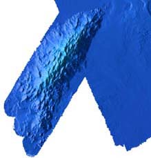
Bathymetric map of Davidson Seamount
Summary[edit]
| Description |
English: Bathymetric showing details of Davidson Seamount
Français : Bathymétrie du Mont sous-marin Davidson, situé au large de la Californie |
| Date | import in Commons : 2010/10/30 |
| Source | NOAA, in English wikipedia ;Direct link ; |
| Author | NOAA |
| Permission (Reusing this file) |
Public domain because it is the work of the NOAA, part of the United States Government. |
Licensing[edit]
This image is in the public domain because it contains materials that originally came from the U.S. National Oceanic and Atmospheric Administration, taken or made as part of an employee's official duties.
|
File history
Click on a date/time to view the file as it appeared at that time.
| Date/Time | Thumbnail | Dimensions | User | Comment | |
|---|---|---|---|---|---|
| current | 08:33, 30 October 2010 | | 1,034 × 1,201 (228 KB) | Lamiot (talk | contribs) | {{Information |Description= {{en|Bathymetric showing details of Davidson Seamount}} {{en|Bathymétrie du Mont sous-marin Davidson, situé au large de la Californie}} |Source= NOAA, in English wikipedia ;[http://oceanexplorer.noaa.gov/e |
You cannot overwrite this file.
File usage on Commons
There are no pages that use this file.
File usage on other wikis
The following other wikis use this file:
- Usage on en.wikipedia.org
- Usage on en.wikiversity.org
- Usage on fr.wikipedia.org
- Usage on nl.wikipedia.org