File:Site Plan and Aerial View - Marshall Space Flight Center, F-1 Engine Static Test Stand, On Route 565 between Huntsville and Decatur , Huntsville, Madison County, AL HAER AL-129-L (sheet 2 of 15).tif
Jump to navigation
Jump to search

Size of this JPG preview of this TIF file: 400 × 600 pixels. Other resolutions: 160 × 240 pixels | 320 × 480 pixels | 512 × 768 pixels | 682 × 1,024 pixels | 1,365 × 2,048 pixels | 4,800 × 7,200 pixels.
Original file (4,800 × 7,200 pixels, file size: 2.03 MB, MIME type: image/tiff)
Captions
Captions
Add a one-line explanation of what this file represents
Summary[edit]
| Site Plan and Aerial View - Marshall Space Flight Center, F-1 Engine Static Test Stand, On Route 565 between Huntsville and Decatur , Huntsville, Madison County, AL | ||||
|---|---|---|---|---|
| Photographer |
Martin, Abby, creator |
|||
| Title |
Site Plan and Aerial View - Marshall Space Flight Center, F-1 Engine Static Test Stand, On Route 565 between Huntsville and Decatur , Huntsville, Madison County, AL |
|||
| Depicted place | Alabama; Madison County; Huntsville | |||
| Date | 2009 | |||
| Current location |
Library of Congress Prints and Photographs Division Washington, D.C. 20540 USA http://hdl.loc.gov/loc.pnp/pp.print |
|||
| Accession number |
HAER AL-129-L (sheet 2 of 15) |
|||
| Credit line |
|
|||
| Notes |
|
|||
| References |
Related names:
|
|||
| Source | https://www.loc.gov/pictures/item/al1331.sheet.00002a | |||
| Permission (Reusing this file) |
|
|||
| Other versions |
        |
|||

| Camera location | | View this and other nearby images on: OpenStreetMap |
|---|
File history
Click on a date/time to view the file as it appeared at that time.
| Date/Time | Thumbnail | Dimensions | User | Comment | |
|---|---|---|---|---|---|
| current | 23:05, 26 June 2014 | 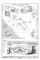 | 4,800 × 7,200 (2.03 MB) | Fæ (talk | contribs) | GWToolset: Creating mediafile for Fæ. HABS batch upload 26 June 2014 (151:200) |
You cannot overwrite this file.
File usage on Commons
The following 9 pages use this file:
- File:Building Section - Marshall Space Flight Center, F-1 Engine Static Test Stand, On Route 565 between Huntsville and Decatur , Huntsville, Madison County, AL HAER AL-129-L (sheet 7 of 15).tif
- File:Cover Sheet and Site Plan - Marshall Space Flight Center, F-1 Engine Static Test Stand, On Route 565 between Huntsville and Decatur , Huntsville, Madison County, AL HAER AL-129-L (sheet 1 of 15).tif
- File:Details at Interior Work Platform - Marshall Space Flight Center, F-1 Engine Static Test Stand, On Route 565 between Huntsville and Decatur , Huntsville, Madison County, HAER AL-129-L (sheet 8 of 15).tif
- File:Flame Deflector - Section, Elevation, Water Supply Flow Diagram, Exploded Deflector Manifolds, and Interior Perspective - Marshall Space Flight Center, F-1 Engine Static HAER AL-129-L (sheet 13 of 15).tif
- File:Floor Plans - Foundation Plan at Bedrock and Subgrade Level Plan - Marshall Space Flight Center, F-1 Engine Static Test Stand, On Route 565 between Huntsville and Decatur HAER AL-129-L (sheet 3 of 15).tif
- File:Floor Plans - Grade Level and Aspirator Level Plans - Marshall Space Flight Center, F-1 Engine Static Test Stand, On Route 565 between Huntsville and Decatur , Huntsville HAER AL-129-L (sheet 4 of 15).tif
- File:Floor Plans - Rolling Platform, Tech Systems Platform, and Load Platform Plans - Marshall Space Flight Center, F-1 Engine Static Test Stand, On Route 565 between HAER AL-129-L (sheet 5 of 15).tif
- File:Loading and Testing the Engine - Marshall Space Flight Center, F-1 Engine Static Test Stand, On Route 565 between Huntsville and Decatur , Huntsville, Madison County, AL HAER AL-129-L (sheet 14 of 15).tif
- File:Site Plan and Aerial View - Marshall Space Flight Center, F-1 Engine Static Test Stand, On Route 565 between Huntsville and Decatur , Huntsville, Madison County, AL HAER AL-129-L (sheet 2 of 15).tif