File:Southwold Lifeboat Station, Suffolk - geograph.org.uk - 44582.jpg
Jump to navigation
Jump to search
No higher resolution available.
Southwold_Lifeboat_Station,_Suffolk_-_geograph.org.uk_-_44582.jpg (640 × 480 pixels, file size: 68 KB, MIME type: image/jpeg)
Captions
Captions
Add a one-line explanation of what this file represents
Summary[edit]
| Description |
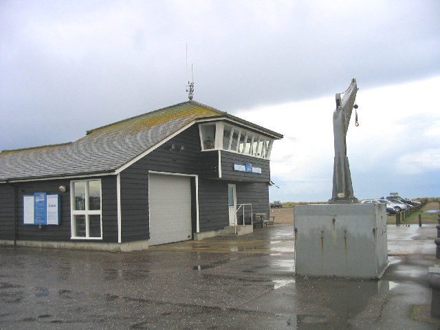
English: Southwold Lifeboat Station, Suffolk. This station houses an ATLANTIC 75 Class inshore rescue craft. The hoist on the right is used to launch the boat because of the tidal range of River Blyth. Français : La grue sur le côté est utilisée pour mettre le canot de sauvetage à l'eau à cause du niveau variable de la Blyth en fonction des marées. |
| Date | |
| Source | From geograph.org.uk |
| Author | John Winfield |
| Attribution (required by the license) | John Winfield / Southwold Lifeboat Station, Suffolk / |
| Object location | | View this and other nearby images on: OpenStreetMap |
|---|
_&language=en)
Licensing[edit]

|
This image was taken from the Geograph project collection. See this photograph's page on the Geograph website for the photographer's contact details. The copyright on this image is owned by John Winfield and is licensed for reuse under the Creative Commons Attribution-ShareAlike 2.0 license.
|
This file is licensed under the Creative Commons Attribution-Share Alike 2.0 Generic license.
Attribution: John Winfield
- You are free:
- to share – to copy, distribute and transmit the work
- to remix – to adapt the work
- Under the following conditions:
- attribution – You must give appropriate credit, provide a link to the license, and indicate if changes were made. You may do so in any reasonable manner, but not in any way that suggests the licensor endorses you or your use.
- share alike – If you remix, transform, or build upon the material, you must distribute your contributions under the same or compatible license as the original.
File history
Click on a date/time to view the file as it appeared at that time.
| Date/Time | Thumbnail | Dimensions | User | Comment | |
|---|---|---|---|---|---|
| current | 18:38, 30 January 2010 | | 640 × 480 (68 KB) | GeographBot (talk | contribs) | == {{int:filedesc}} == {{Information |description={{en|1=Southwold Lifeboat Station, Suffolk. This station houses an ATLANTIC 75 Class inshore rescue craft. The hoist on the right is used to launch the boat because of the tidal range of River Blyth.}} |da |
You cannot overwrite this file.
File usage on Commons
There are no pages that use this file.
File usage on other wikis
The following other wikis use this file:
- Usage on azb.wikipedia.org
- Usage on en.wikipedia.org
- Usage on fr.wikipedia.org