File:Straßenbahn Berlin Netz 2014.png
Jump to navigation
Jump to search
Size of this preview: 556 × 599 pixels. Other resolutions: 223 × 240 pixels | 445 × 480 pixels | 712 × 768 pixels | 950 × 1,024 pixels | 1,900 × 2,048 pixels | 4,500 × 4,851 pixels.
Original file (4,500 × 4,851 pixels, file size: 9.87 MB, MIME type: image/png)
Captions
Captions
Add a one-line explanation of what this file represents
Summary[edit]
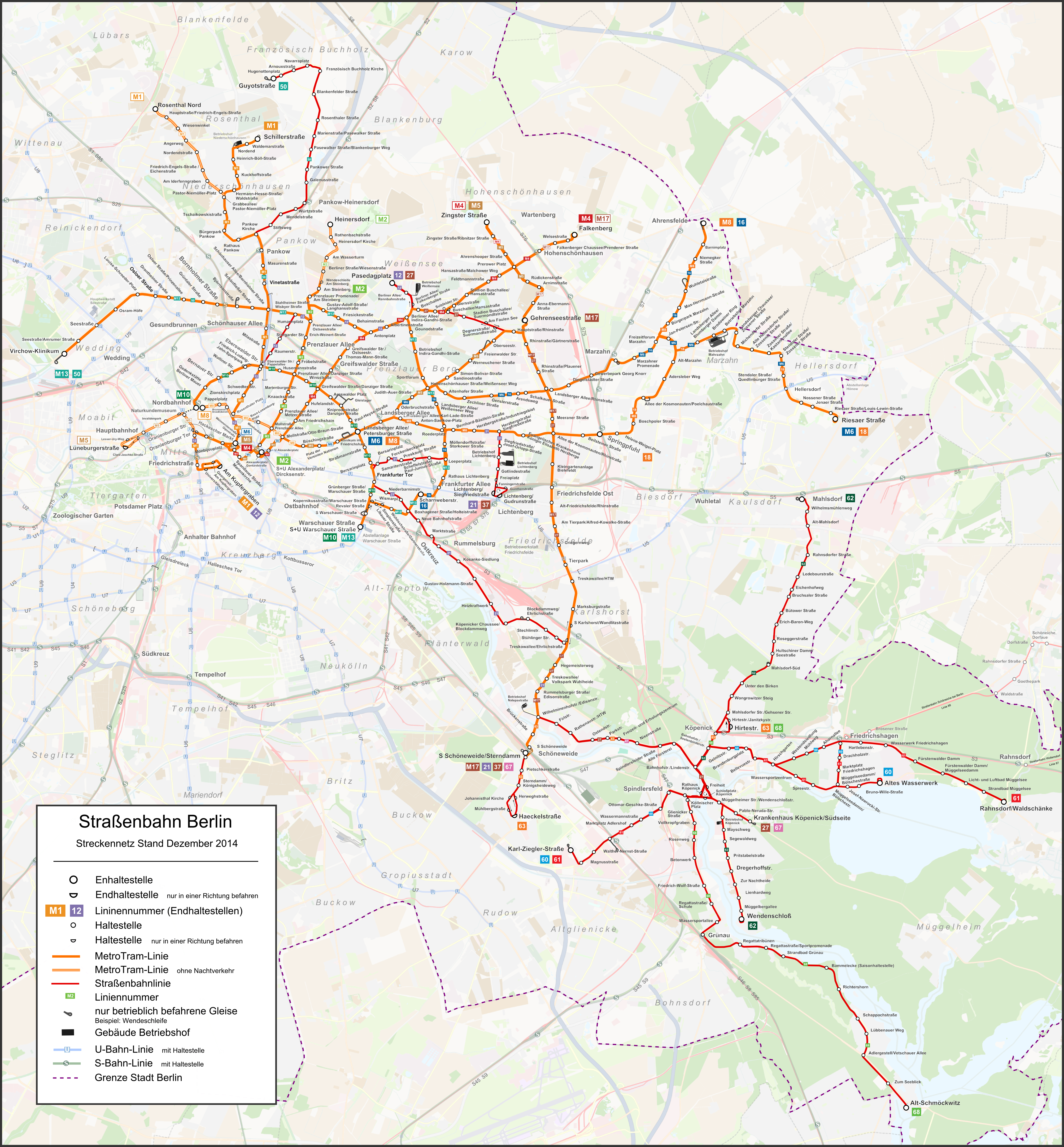
| Description |
|
| Date | |
| Source | Self made with OSM Data. |
| Author | Pechristener |
| Permission (Reusing this file) |
Map data (c) OpenStreetMap (and) contributors, CC-BY-SA |
| Other versions |
|

Licensing[edit]
This file is licensed under the Creative Commons Attribution-Share Alike 2.0 Generic license.
- You are free:
- to share – to copy, distribute and transmit the work
- to remix – to adapt the work
- Under the following conditions:
- attribution – You must give appropriate credit, provide a link to the license, and indicate if changes were made. You may do so in any reasonable manner, but not in any way that suggests the licensor endorses you or your use.
- share alike – If you remix, transform, or build upon the material, you must distribute your contributions under the same or compatible license as the original.
File history
Click on a date/time to view the file as it appeared at that time.
| Date/Time | Thumbnail | Dimensions | User | Comment | |
|---|---|---|---|---|---|
| current | 19:04, 25 February 2016 | | 4,500 × 4,851 (9.87 MB) | Pechristener (talk | contribs) | Haltestelle Reifenwerk an der 68 in Schmöckwitz existiert seit 2012 |
| 17:10, 15 February 2015 |  | 4,500 × 4,851 (8.21 MB) | Kopiersperre (talk | contribs) | optipng | |
| 16:00, 15 February 2015 |  | 4,500 × 4,851 (9.87 MB) | Pechristener (talk | contribs) | Verlkängerung zum Hbf eingearbeitet / Karte vergrössert | |
| 08:19, 15 February 2015 |  | 3,899 × 4,203 (8.5 MB) | Pechristener (talk | contribs) | verbesserter Hintergrund | |
| 23:51, 5 November 2014 |  | 3,899 × 4,203 (5.27 MB) | Pechristener (talk | contribs) | Linien-Beschriftung von U- und S-Bahn, sowie Strassenbahnen in Friedrichshagen und Rahnsdorf. Diverse verolren gegangenen Beschriftungen wieder hinzugefügt. | |
| 21:28, 3 November 2014 |  | 3,899 × 4,203 (5.95 MB) | Pechristener (talk | contribs) | Legende hinzugefügt, Rest von Disk noch nicht abgearbeitet | |
| 20:48, 23 October 2014 |  | 3,899 × 4,203 (4.37 MB) | Pechristener (talk | contribs) | nachgebessert: Haltestellen, die nur in einer Richtung bedient werden, gekennzeichnet / U- und S-Bahnen schwächer und nur die wichtigen Stationen beschriftet / Lineinnummern hinzu | |
| 12:34, 19 October 2014 |  | 3,899 × 4,203 (4.29 MB) | Pechristener (talk | contribs) | noch nicht fertig, Anpassungen gem. Disk KW:Kartenwünsche | |
| 18:00, 5 October 2014 |  | 3,899 × 4,203 (4.61 MB) | Pechristener (talk | contribs) | vervollständigt | |
| 08:00, 2 October 2014 |  | 3,899 × 4,203 (4.41 MB) | Pechristener (talk | contribs) | {{Information |Description= *{{de|Netzplan der Straßenbahn Berlin (noch nicht ganz fertig !!)}} *{{en|Map of Hannover Regional-Bahn (not yet finished !!)}} |Source=Self made with OSM Data. |Date=2014-10 |Author= Pechristener |Per... |
You cannot overwrite this file.
File usage on Commons
The following 14 pages use this file:
- User:Chumwa/OgreBot/Public transport information/2014 October 1-10
- User:Chumwa/OgreBot/Public transport information/2015 February 10-18
- User:Chumwa/OgreBot/Public transport information/2016 February 20-29
- User:Chumwa/OgreBot/Transport Maps/2014 October 1-10
- User:Chumwa/OgreBot/Transport Maps/2015 February 10-18
- User:Chumwa/OgreBot/Transport Maps/2016 February 20-29
- User:Chumwa/OgreBot/Travel and communication maps/2016 February 20-29
- User:Liesel/Rail transport/2014 October 1-10
- User:Liesel/Rail transport/2015 February 10-18
- User:Nordlicht8/Rail Germany/2014 October 1-10
- User:Nordlicht8/Rail Germany/2015 February 10-18
- User:Nordlicht8/Rail Germany/2016 February 20-29
- File:Straßenbahn Berlin Netz Dezember 2022.png
- File:Straßenbahn Berlin Netz September 2015.png
File usage on other wikis
The following other wikis use this file:
- Usage on de.wikipedia.org
- Usage on id.wikipedia.org
- Usage on it.wikipedia.org
- Usage on nl.wikipedia.org
- Usage on www.wikidata.org