File:TabaterieAbri.jpg
Jump to navigation
Jump to search

Size of this preview: 450 × 600 pixels. Other resolutions: 180 × 240 pixels | 360 × 480 pixels | 576 × 768 pixels | 768 × 1,024 pixels | 1,536 × 2,048 pixels | 2,736 × 3,648 pixels.
Original file (2,736 × 3,648 pixels, file size: 1.83 MB, MIME type: image/jpeg)
Captions
Captions
Add a one-line explanation of what this file represents
Summary[edit]
| Description |
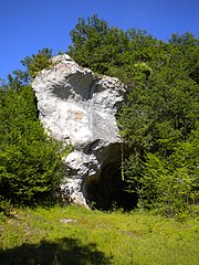
English: Rock shelter (abri) in Coniacian limestone in the Boulou valley (left-hand side) near La Tabaterie, commune of La Gonterie-Boulouneix, Dordogne, France. In the abri there is a natural spring and next to it a deep well - dangerous!
Deutsch: Steilwand im Bouloutal aus Coniacium mit Abri. Unweit von La Tabaterie, gehörend zur Gemeinde La Gonterie-Boulouneix, Dordogne, Frankreich. Im Abri befindet sich eine natürliche Quelle. Davor ein tiefer und gefährlich wirkender Brunnenschacht.
Français : Abri dans le calcaire Cognacien de la vallée du Boulou. Près de la Tabaterie, commune de La Gonterie-Boulouneix, Dordogne, France. Il y a une source naturelle dans l'abri et un puits dangereux.
|
||
| Date | |||
| Source | Own work | ||
| Author | Rudolf Pohl |
| Object location | | View this and other nearby images on: OpenStreetMap |
|---|
Licensing[edit]
I, the copyright holder of this work, hereby publish it under the following licenses:
This file is licensed under the Creative Commons Attribution-Share Alike 3.0 Unported license.
- You are free:
- to share – to copy, distribute and transmit the work
- to remix – to adapt the work
- Under the following conditions:
- attribution – You must give appropriate credit, provide a link to the license, and indicate if changes were made. You may do so in any reasonable manner, but not in any way that suggests the licensor endorses you or your use.
- share alike – If you remix, transform, or build upon the material, you must distribute your contributions under the same or compatible license as the original.

|
Permission is granted to copy, distribute and/or modify this document under the terms of the GNU Free Documentation License, Version 1.2 or any later version published by the Free Software Foundation; with no Invariant Sections, no Front-Cover Texts, and no Back-Cover Texts. A copy of the license is included in the section entitled GNU Free Documentation License. |
You may select the license of your choice.
File history
Click on a date/time to view the file as it appeared at that time.
| Date/Time | Thumbnail | Dimensions | User | Comment | |
|---|---|---|---|---|---|
| current | 12:26, 26 June 2010 | | 2,736 × 3,648 (1.83 MB) | Rudolf Pohl (talk | contribs) | {{Information |Description={{en|1=Rock shelter (abri) in Coniacian limestone in the Boulou valley (left-hand side) near La Tabaterie, commune of La Gonterie-Boulouneix, Dordogne, France. In the abri there is a natural spring and next to it a deep well - d |
You cannot overwrite this file.
File usage on Commons
The following page uses this file:
File usage on other wikis
The following other wikis use this file:
- Usage on de.wikipedia.org
- Usage on fr.wikipedia.org
- Usage on ru.wikipedia.org
- Usage on www.wikidata.org