File:Tel Ubeidiya (5).JPG
Jump to navigation
Jump to search

Size of this preview: 800 × 600 pixels. Other resolutions: 320 × 240 pixels | 640 × 480 pixels | 1,024 × 768 pixels | 1,280 × 960 pixels | 2,560 × 1,920 pixels | 4,608 × 3,456 pixels.
Original file (4,608 × 3,456 pixels, file size: 3.16 MB, MIME type: image/jpeg)
Captions
Captions
Add a one-line explanation of what this file represents
Summary[edit]
.JPG&action=edit§ion=1)
| Description |
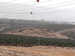
Tel Ubeidiya 3 km south of Lake Tiberias, in the Jordan Rift Valley, Israel, is an archaeological site of the Pleistocene תל עובדיה הוא תל בין המושבה מנחמיה לקיבוץ בית זרע, אשר בקרבתו אתר פרהיסטורי הנחשב לאחד האתרים הקדומים ביותר בעולם ובעל חשיבות רבה בקנה מידה עולמי להבנת האבולוציה של האדם. |
| Date | |
| Source | Own work |
| Author | Hanay |
| Permission (Reusing this file) |
This file is licensed under the Creative Commons Attribution-Share Alike 3.0 Unported license. Attribution: Hanay
|
| Camera location | | View this and other nearby images on: OpenStreetMap |
|---|
.JPG¶ms=032.692190_N_0035.556042_E_globe:Earth_type:camera_heading:113.50&language=en)
File history
Click on a date/time to view the file as it appeared at that time.
| Date/Time | Thumbnail | Dimensions | User | Comment | |
|---|---|---|---|---|---|
| current | 16:08, 17 May 2012 | | 4,608 × 3,456 (3.16 MB) | Hanay (talk | contribs) |
You cannot overwrite this file.
File usage on Commons
The following page uses this file:
.JPG&oldid=514575348)