File:The Obelisk of Theodosius, Hippodrome, Istanbul (8369127405).jpg

Original file (2,780 × 4,020 pixels, file size: 7.98 MB, MIME type: image/jpeg)
Captions
Captions
Summary[edit]
| DescriptionThe Obelisk of Theodosius, Hippodrome, Istanbul (8369127405).jpg |
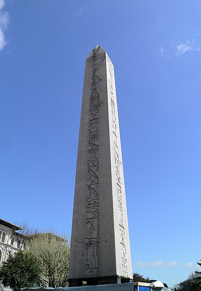
Theodosius oversaw the removal in 390 of an Egyptian obelisk from Alexandria to Constantinople. It is now known as the obelisk of Theodosius and still stands in the Hippodrome, the long racetrack that was the center of Constantinople's public life and scene of political turmoil. Re-erecting the monolith was a challenge for the technology that had been honed in the construction of siege engines. The obelisk, still recognizably a solar symbol, had been moved from Karnak to Alexandria with what is now the Lateran obelisk by Constantius II). The Lateran obelisk was shipped to Rome soon afterwards, but the other one then spent a generation lying at the docks due to the difficulty involved in attempting to ship it to Constantinople. Eventually, the obelisk was cracked in transit. The white marble base is entirely covered with bas-reliefs documenting the Imperial household and the engineering feat of removing it to Constantinople. Theodosius and the Imperial family are separated from the nobles among the spectators in the Imperial box, with a cover over them as a mark of their status. The naturalism of traditional Roman art in such scenes gave way in these reliefs to conceptual art: the idea of order, decorum and respective ranking, expressed in serried ranks of faces. This is seen as evidence of formal themes beginning to oust the transitory details of mundane life, celebrated in Pagan portraiture. Christianity had only just been adopted as the new state religion. The Forum Tauri in Constantinople was renamed and redecorated as the Forum of Theodosius, including a column and a triumphal arch in his honour. |
| Date | |
| Source |
The Obelisk of Theodosius, Hippodrome, Istanbul
|
| Author | Carole Raddato from FRANKFURT, Germany |
| Camera location | 41° 02′ 27.06″ N, 28° 59′ 10.24″ E | View this and other nearby images on: OpenStreetMap |
|---|
Licensing[edit]
- You are free:
- to share – to copy, distribute and transmit the work
- to remix – to adapt the work
- Under the following conditions:
- attribution – You must give appropriate credit, provide a link to the license, and indicate if changes were made. You may do so in any reasonable manner, but not in any way that suggests the licensor endorses you or your use.
- share alike – If you remix, transform, or build upon the material, you must distribute your contributions under the same or compatible license as the original.
| This image, originally posted to Flickr, was reviewed on 14 December 2013 by the administrator or reviewer File Upload Bot (Magnus Manske), who confirmed that it was available on Flickr under the stated license on that date. |
File history
Click on a date/time to view the file as it appeared at that time.
| Date/Time | Thumbnail | Dimensions | User | Comment | |
|---|---|---|---|---|---|
| current | 19:06, 14 December 2013 |  | 2,780 × 4,020 (7.98 MB) | File Upload Bot (Magnus Manske) (talk | contribs) | Transferred from Flickr by User:Marcus Cyron |
You cannot overwrite this file.
File usage on Commons
There are no pages that use this file.
Metadata
This file contains additional information such as Exif metadata which may have been added by the digital camera, scanner, or software program used to create or digitize it. If the file has been modified from its original state, some details such as the timestamp may not fully reflect those of the original file. The timestamp is only as accurate as the clock in the camera, and it may be completely wrong.
| Image title | OLYMPUS DIGITAL CAMERA |
|---|---|
| Camera manufacturer | OLYMPUS IMAGING CORP. |
| Camera model | SP800UZ |
| Exposure time | 1/320 sec (0.003125) |
| F-number | f/5.7 |
| ISO speed rating | 50 |
| Date and time of data generation | 08:38, 22 April 2011 |
| Lens focal length | 4.9 mm |
| Orientation | Rotated 90° CCW |
| Horizontal resolution | 72 dpi |
| Vertical resolution | 72 dpi |
| Software used | Version 1.0 |
| File change date and time | 08:38, 22 April 2011 |
| Y and C positioning | Co-sited |
| Exposure Program | Creative program (biased toward depth of field) |
| Exif version | 2.21 |
| Date and time of digitizing | 08:38, 22 April 2011 |
| Meaning of each component |
|
| Image compression mode | 4 |
| APEX exposure bias | 0 |
| Maximum land aperture | 2.97 APEX (f/2.8) |
| Metering mode | Pattern |
| Light source | Unknown |
| Flash | Flash did not fire, compulsory flash suppression |
| Supported Flashpix version | 1 |
| Color space | sRGB |
| File source | Digital still camera |
| Scene type | A directly photographed image |
| Custom image processing | Normal process |
| Exposure mode | Auto exposure |
| White balance | Auto white balance |
| Digital zoom ratio | 0 |
| Focal length in 35 mm film | 28 mm |
| Scene capture type | Standard |
| Scene control | None |
| Contrast | Normal |
| Saturation | Normal |
| Sharpness | Normal |