File:The battle of the Atlantic 1941 map-de.png
Jump to navigation
Jump to search

Size of this preview: 436 × 599 pixels. Other resolutions: 175 × 240 pixels | 349 × 480 pixels | 559 × 768 pixels | 746 × 1,024 pixels | 1,511 × 2,075 pixels.
Original file (1,511 × 2,075 pixels, file size: 442 KB, MIME type: image/png)
Captions
Captions
Add a one-line explanation of what this file represents
Summary[edit]
| Description |
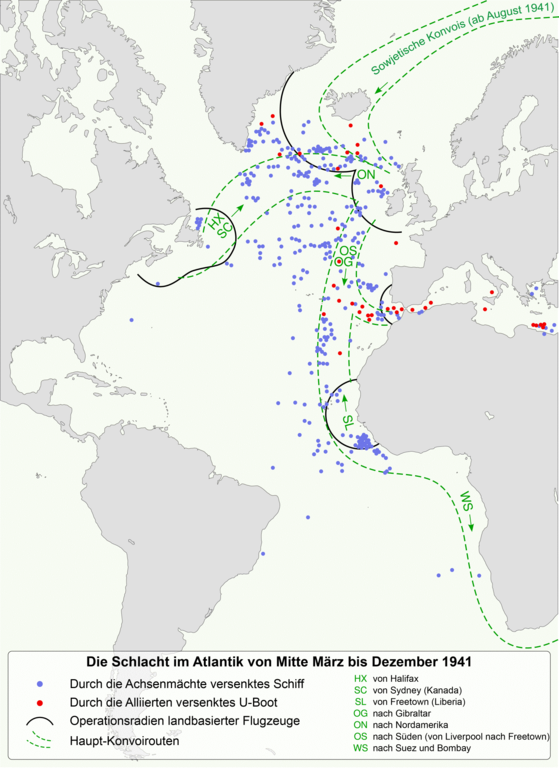
Deutsch: Die Schlacht im Atlantik, Mitte März bis Dezember 1941.
In der zweiten Aprilhälfte wurden die engen Eskorten durch große Sicherheitszonen und großflächige Suchen ersetzt. Im Mai 1941 umfassten diese 560 Kilometer um Island und Nordirland herum. Die Operationen von Basen in West-Afrika begannen ab dem 24. März 1941. Hudsons und Seeaufklärungsflugzeuge vom Typ Catalina operierten von Gibraltar aus bis zu 400 Kilometer weit. *Mercator-Projektion; geodätisches System WGS84 *Koordinaten : 73.5 N, -56.5 S, 30 E, -100 W Français : La bataille de l'Atlantique, entre la mi-mars et décembre 1941.
À partir de fin avril, les recherches aériennes de sous-marins remplacent les escortes rapprochées. En mai 1941, ces recherches s'étendent à 350 miles (~ 560 kilomètres) de l'Islande et l'Irlande du Nord. Les opérations à partir des bases d'Afrique de l'Ouest débutent le 24 Mars 1941. Les Hudsons et les Catalinas opèrent depuis Gibraltar jusqu'à 250 miles (~ 400 kilomètres). Le rapport des pertes alliées et le déroulement chronologique sont visible sur le fichier Monthly Losses of Allied and Neutral Shipping by U-boat Action-fr.svg et le rapport des pertes de l'Axe sur le fichier Battle of the Atlantic (WW2) - German submarines lost-fr.svg. *Projection de Mercator ; système géodésique WGS 84 *Coordonnées : 73.5 N, -56.5 S, 30 E, -100 O English: The battle of the Atlantic, mid-march to december 1941. In the latter part of April, sweeps and searches replaced close escort. In May 1941 these extends 350 miles from Iceland and North Ireland. Operations from West African bases began on 24 March 1941. Hudsons and Catalinas operated from Gibraltar up to 250 miles. *Mercator projection; geodetic system WGS84 *Coordinates : 73.5 N, -56.5 S, 30 E, -100 W |
| Date | (UTC) |
| Source | |
| Author |
|
_-_German_submarines_lost-fr.svg)
| This is a retouched picture, which means that it has been digitally altered from its original version. Modifications: traduction allemand/deutsche Übersetzung/German translation. The original can be viewed here: The battle of the Atlantic 1941 map-fr.svg:
|
Licensing[edit]
I, the copyright holder of this work, hereby publish it under the following licenses:
This file is licensed under the Creative Commons Attribution-Share Alike 3.0 Unported, 2.5 Generic, 2.0 Generic and 1.0 Generic license.
- You are free:
- to share – to copy, distribute and transmit the work
- to remix – to adapt the work
- Under the following conditions:
- attribution – You must give appropriate credit, provide a link to the license, and indicate if changes were made. You may do so in any reasonable manner, but not in any way that suggests the licensor endorses you or your use.
- share alike – If you remix, transform, or build upon the material, you must distribute your contributions under the same or compatible license as the original.
| Copyleft: This work of art is free; you can redistribute it and/or modify it according to terms of the Free Art License. You will find a specimen of this license on the Copyleft Attitude site as well as on other sites. |
You may select the license of your choice.
Original upload log[edit]
This image is a derivative work of the following images:
- File:The_battle_of_the_Atlantic_1941_map-fr.svg licensed with Cc-by-sa-3.0,2.5,2.0,1.0, FAL
- 2011-10-17T07:53:38Z Sémhur 1447x1990 (458229 Bytes) Modification d'un texte de légende
- 2011-10-13T17:46:39Z Sémhur 1447x1990 (411486 Bytes) Precision
- 2011-10-12T19:55:16Z Sémhur 1447x1990 (402042 Bytes) Correct size
- 2011-10-12T19:49:37Z Sémhur 512x704 (398274 Bytes) == {{int:filedesc}} == {{Information |Description={{Multilingual description |en= The [[:en:Battle of the Atlantic (1939–1945)|battle of the Atlantic]], mid-march to december 1941. In the latter part of April, sweeps and se
Uploaded with derivativeFX
File history
Click on a date/time to view the file as it appeared at that time.
| Date/Time | Thumbnail | Dimensions | User | Comment | |
|---|---|---|---|---|---|
| current | 01:40, 26 December 2011 | | 1,511 × 2,075 (442 KB) | Furfur (talk | contribs) | neuer versuch |
| 01:35, 26 December 2011 |  | 3,022 × 4,150 (1.4 MB) | Furfur (talk | contribs) | Farben reduziert | |
| 01:32, 26 December 2011 |  | 3,022 × 4,150 (947 KB) | Furfur (talk | contribs) | == {{int:filedesc}} == {{Information |Description={{Multilingual description |de= Die Schlacht im Atlantik, Mitte März bis Dezember 1941.<br> In der zweiten Aprilhälfte wurden die engen Eskorten durch große Sicherheitszone |
You cannot overwrite this file.
File usage on Commons
The following page uses this file:
File usage on other wikis
The following other wikis use this file:
- Usage on de.wikipedia.org
- Usage on sv.wikipedia.org