File:Titan map october 2006.jpg
Jump to navigation
Jump to search

Size of this preview: 800 × 444 pixels. Other resolutions: 320 × 178 pixels | 640 × 356 pixels | 1,024 × 569 pixels | 1,280 × 711 pixels | 2,560 × 1,422 pixels | 8,748 × 4,860 pixels.
Original file (8,748 × 4,860 pixels, file size: 5.36 MB, MIME type: image/jpeg)
Captions
Captions
Add a one-line explanation of what this file represents
Summary[edit]
| Description |
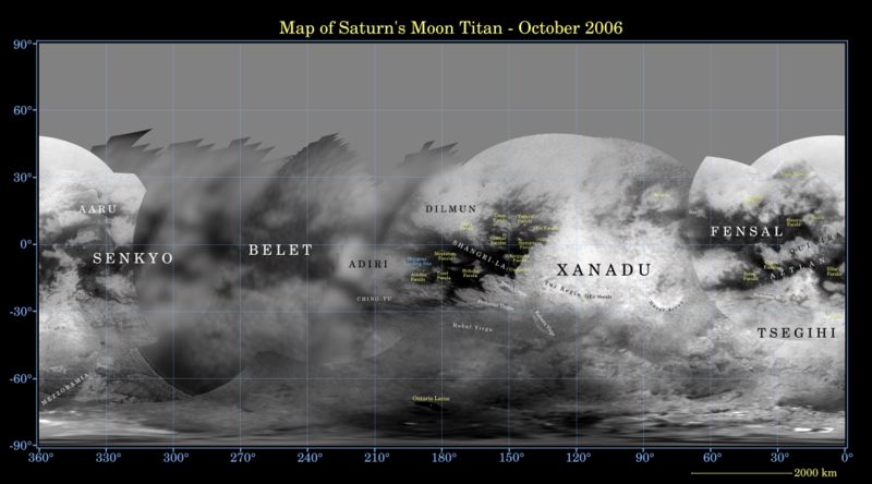
English: Map of Titan's surface. Mosaic created using data taken by the Cassini spacecraft Imaging Science Subsystem (ISS).
The data here consist of images taken using a filter centered at 938 nanometers, allowing researchers to examine albedo (or inherent brightness) variations across the surface of Titan. Due to the scattering of light by Titan's dense atmosphere, no topographic shading is visible in these images. Deutsch: Karte des Titan von Oktober 2006 in Äquidistanzprojektion. Dieses Mosaik wurde aus Daten des Imaging Science Subsystems der Raumsonde Cassini zusammengestellt. |
| Date | |
| Source | http://photojournal.jpl.nasa.gov/catalog/PIA08346 |
| Author | NASA/JPL/Space Science Institute |
| Permission (Reusing this file) |
http://www.jpl.nasa.gov/images/policy/ |
This image or video was catalogued by Jet Propulsion Laboratory of the United States National Aeronautics and Space Administration (NASA) under Photo ID: PIA08346. This tag does not indicate the copyright status of the attached work. A normal copyright tag is still required. See Commons:Licensing. Other languages:
|
Licensing[edit]
| This file is in the public domain in the United States because it was solely created by NASA. NASA copyright policy states that "NASA material is not protected by copyright unless noted". (See Template:PD-USGov, NASA copyright policy page or JPL Image Use Policy.) | ||
 |
Warnings:
|
File history
Click on a date/time to view the file as it appeared at that time.
| Date/Time | Thumbnail | Dimensions | User | Comment | |
|---|---|---|---|---|---|
| current | 18:48, 1 January 2007 | | 8,748 × 4,860 (5.36 MB) | Winiar (talk | contribs) | {{Information |Description=Map of Titan's surface. Mosaic created using data taken by the Cassini spacecraft Imaging Science Subsystem (ISS). <br>The data here consist of images taken using a filter centered at 938 nanometers, allowing researchers to exam |
You cannot overwrite this file.
File usage on Commons
There are no pages that use this file.
File usage on other wikis
The following other wikis use this file:
- Usage on de.wikipedia.org
- Usage on gl.wikipedia.org
- Usage on lb.wikipedia.org