File:Tsushima Omega Tower 1977 2.jpg
Jump to navigation
Jump to search

Size of this preview: 799 × 600 pixels. Other resolutions: 320 × 240 pixels | 640 × 480 pixels | 1,023 × 768 pixels | 1,107 × 831 pixels.
Original file (1,107 × 831 pixels, file size: 251 KB, MIME type: image/jpeg)
Captions
Captions
Add a one-line explanation of what this file represents
Summary[edit]
| Description |
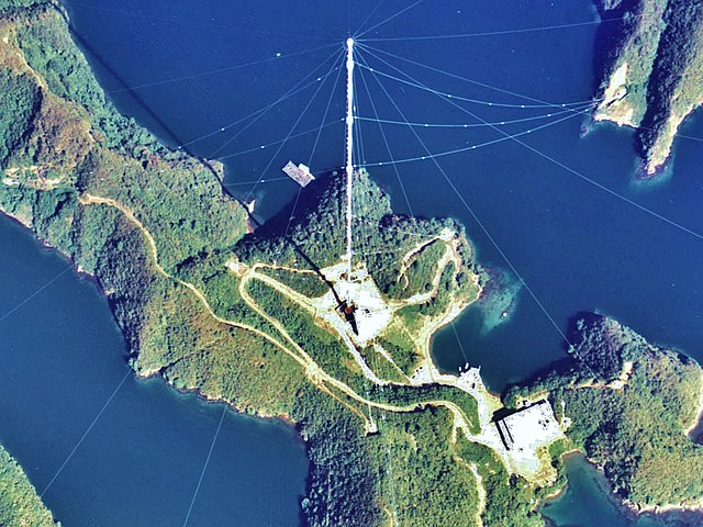
English: Shushi-Wan Omega Transmitter (station H) of the Omega navigation system, an obsolete worldwide navigation system, which transmitted in the VLF band on 10 - 14 kHz. The antenna, situated near Shushi-Wan on Tsushima Island was an umbrella antenna consisting of a 389-metre tall tubular steel mast, insulated against ground, with 14 wires extending diagonally from the top to the ground. This mast, which was built in 1973 and which was the tallest structure in Japan (and perhaps the tallest tubular steel mast ever built) was dismantled in 1998.
日本語: 対馬オメガ局。 |
|||
| Date | ||||
| Source | Japan Ministry of Land, Infrastructure and Transport. [1] | |||
| Author | retouch: Qurren (talk). | |||
| Other versions |
|
| Camera location | | View this and other nearby images on: OpenStreetMap |
|---|
Licensing[edit]

|
The copyright holder of this file, the Ministry of Land, Infrastructure, Transport and Tourism of Japan, allows anyone to use it for any purpose, provided that the copyright holder is properly attributed. Redistribution, derivative work, commercial use, and all other use is permitted. |
Attribution:
Copyright © National Land Image Information (Color Aerial Photographs), Ministry of Land, Infrastructure, Transport and Tourism
|
 |
This image is copyrighted by the Ministry of Land, Infrastructure, Transport and Tourism of Japan. For terms of use, see the stipulation to use of National Land Information (in Japanese) and message from MLIT (in Japanese and English). When you display this image on an article, include the following phrase in the description: "Made based on National Land Image Information (Color Aerial Photographs), Ministry of Land, Infrastructure, Transport and Tourism".
|
File history
Click on a date/time to view the file as it appeared at that time.
| Date/Time | Thumbnail | Dimensions | User | Comment | |
|---|---|---|---|---|---|
| current | 14:09, 6 October 2013 | | 1,107 × 831 (251 KB) | Qurren (talk | contribs) | == {{int:filedesc}} == {{Information |Description={{en|1=en:Tsushima Omega Tower.}} {{ja|1=ja:対馬オメガ局。}} |Source=Japan Ministry of Land, Infrastructure and Transport. [http://w3land.mlit.go.jp/cgi-bin/WebGIS2/WC_AirPhoto.cgi?IT... |
You cannot overwrite this file.
File usage on Commons
The following 2 pages use this file:
File usage on other wikis
The following other wikis use this file:
- Usage on en.wikipedia.org
- Usage on fr.wikipedia.org
- Usage on ja.wikipedia.org
- Usage on ko.wikipedia.org
- Usage on uk.wikipedia.org
- Usage on www.wikidata.org