File:Turmer Hall Ganstead.jpg
Jump to navigation
Jump to search
No higher resolution available.
Turmer_Hall_Ganstead.jpg (640 × 443 pixels, file size: 112 KB, MIME type: image/jpeg)
Captions
Captions
Add a one-line explanation of what this file represents
Summary ==
| Description |
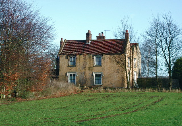
English: Turmer Hall, Ganstead, East Riding of Yorkshire, England. Farmhouse off Longdales Lane near Ganstead's southern township boundary. The earlier east range of the present Turmer Hall probably dates from the 17th century but the building was enlarged with additional parallel ranges by W. G. Todd in 1840. Ganstead became part of the new civil parish of Bilton in 1935. |
| Date | |
| Source | From geograph.org.uk |
| Author | Paul Glazzard |
| Permission (Reusing this file) |
Creative Commons Attribution Share-alike license 2.0 |
| Attribution (required by the license) | Paul Glazzard / Turmer Hall, Ganstead / |
| Camera location | | View this and other nearby images on: OpenStreetMap |
|---|
Licensing[edit]

|
This image was taken from the Geograph project collection. See this photograph's page on the Geograph website for the photographer's contact details. The copyright on this image is owned by Paul Glazzard and is licensed for reuse under the Creative Commons Attribution-ShareAlike 2.0 license.
|
This file is licensed under the Creative Commons Attribution-Share Alike 2.0 Generic license.
Attribution: Paul Glazzard
- You are free:
- to share – to copy, distribute and transmit the work
- to remix – to adapt the work
- Under the following conditions:
- attribution – You must give appropriate credit, provide a link to the license, and indicate if changes were made. You may do so in any reasonable manner, but not in any way that suggests the licensor endorses you or your use.
- share alike – If you remix, transform, or build upon the material, you must distribute your contributions under the same or compatible license as the original.
File history
Click on a date/time to view the file as it appeared at that time.
| Date/Time | Thumbnail | Dimensions | User | Comment | |
|---|---|---|---|---|---|
| current | 22:24, 15 January 2010 | | 640 × 443 (112 KB) | Keith D (talk | contribs) | {{int:filedesc}} == {{Information |Description={{en|1=Turmer Hall, Ganstead, East Riding of Yorkshire<br />Farmhouse off Longdales Lane near Ganstead's southern township boundary. The earlier east range of |
You cannot overwrite this file.
File usage on Commons
There are no pages that use this file.