File:VIEW OF EAST SIDE OF TRUSS -1, LOOKING WEST - Hassler Bridge, Spanning Obey River at State Route 42, Byrdstown, Pickett County, TN HAER TENN,69-BYRD.V,1-5.tif
Jump to navigation
Jump to search

Size of this JPG preview of this TIF file: 749 × 599 pixels. Other resolutions: 300 × 240 pixels | 600 × 480 pixels | 960 × 768 pixels | 1,280 × 1,024 pixels | 2,559 × 2,048 pixels | 5,000 × 4,001 pixels.
Original file (5,000 × 4,001 pixels, file size: 19.08 MB, MIME type: image/tiff)
Captions
Captions
Add a one-line explanation of what this file represents
Summary[edit]
| VIEW OF EAST SIDE OF TRUSS -1, LOOKING WEST - Hassler Bridge, Spanning Obey River at State Route 42, Byrdstown, Pickett County, TN | ||||
|---|---|---|---|---|
| Photographer |
Hornal, George, creator |
|||
| Title |
VIEW OF EAST SIDE OF TRUSS -1, LOOKING WEST - Hassler Bridge, Spanning Obey River at State Route 42, Byrdstown, Pickett County, TN |
|||
| Description |
U.S. Army Corps of Engineers |
|||
| Depicted place | Tennessee; Pickett County; Byrdstown | |||
| Date | 1993 | |||
| Dimensions | 4 x 5 in. | |||
| Current location |
Library of Congress Prints and Photographs Division Washington, D.C. 20540 USA http://hdl.loc.gov/loc.pnp/pp.print |
|||
| Accession number |
HAER TENN,69-BYRD.V,1-5 |
|||
| Credit line |
|
|||
| Notes |
|
|||
| Source | https://www.loc.gov/pictures/item/tn0274.photos.365796p | |||
| Permission (Reusing this file) |
|
|||

File history
Click on a date/time to view the file as it appeared at that time.
| Date/Time | Thumbnail | Dimensions | User | Comment | |
|---|---|---|---|---|---|
| current | 02:21, 2 August 2014 | 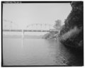 | 5,000 × 4,001 (19.08 MB) | Fæ (talk | contribs) | GWToolset: Creating mediafile for Fæ. HABS 2014-08-01 (3201:3400) |
You cannot overwrite this file.
File usage on Commons
The following page uses this file: