File:Val-de-Marne department location map.svg
Jump to navigation
Jump to search

Size of this PNG preview of this SVG file: 642 × 600 pixels. Other resolutions: 257 × 240 pixels | 514 × 480 pixels | 822 × 768 pixels | 1,096 × 1,024 pixels | 2,192 × 2,048 pixels | 1,322 × 1,235 pixels.
Original file (SVG file, nominally 1,322 × 1,235 pixels, file size: 101 KB)
Captions
Captions
Add a one-line explanation of what this file represents
Summary[edit]
| Camera location | | View this and other nearby images on: OpenStreetMap |
|---|
| Description |
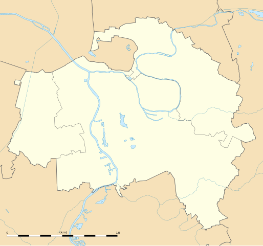
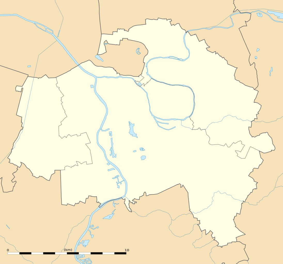
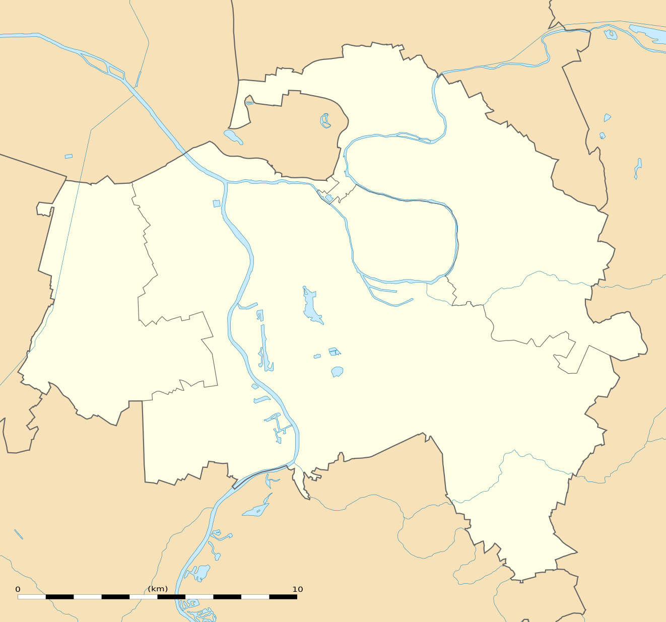
English: Blank administrative map of the department of the Val-de-Marne, France, as in February 2015, for geo-location purpose, with distinct boundaries for departments and arrondissements.
Français : Carte administrative vierge du département du Val-de-Marne, France, tel qu'en février 2015, destinée à la géolocalisation, avec limite distincte des départements et arrondissements. Estimated scale: 1:124,000 (precision: 31 m)
Geographic limits of the map:
|
||
| Date | |||
| Source |
Own work
|
||
| Author | Eric Gaba (Sting - fr:Sting) | ||
| Permission (Reusing this file) |
|
||
| Other versions |
|

Licensing[edit]
Eric Gaba, Wikimedia Commons user Sting, the copyright holder of this work, hereby publishes it under the following license:
This file is licensed under the Creative Commons Attribution-Share Alike 3.0 Unported license.
Attribution: Eric Gaba, Wikimedia Commons user Sting
- You are free:
- to share – to copy, distribute and transmit the work
- to remix – to adapt the work
- Under the following conditions:
- attribution – You must give appropriate credit, provide a link to the license, and indicate if changes were made. You may do so in any reasonable manner, but not in any way that suggests the licensor endorses you or your use.
- share alike – If you remix, transform, or build upon the material, you must distribute your contributions under the same or compatible license as the original.
File history
Click on a date/time to view the file as it appeared at that time.
| Date/Time | Thumbnail | Dimensions | User | Comment | |
|---|---|---|---|---|---|
| current | 16:03, 12 February 2015 | | 1,322 × 1,235 (101 KB) | Sting (talk | contribs) | Boundaries correction |
| 17:18, 9 February 2015 |  | 1,322 × 1,235 (101 KB) | Sting (talk | contribs) | == {{int:filedesc}} == {{Location|48|46|30|N|02|27|45|E|scale:100000}} {{Information |Description={{en|Blank administrative map of the department of the Val-de-Marne, France, as in February 2015, for geo-location purpose, with dist... |
You cannot overwrite this file.
File usage on Commons
The following 3 pages use this file:
File usage on other wikis
The following other wikis use this file:
- Usage on als.wikipedia.org
- Usage on de.wikipedia.org
- Usage on eo.wikipedia.org
- Usage on es.wikipedia.org
- Usage on fr.wikipedia.org
- École supérieure d'ingénieurs en informatique et génie des télécommunications
- Météo-France
- Château de Vincennes
- Fort de Vincennes
- Stade Dominique-Duvauchelle
- Palais des sports Robert-Oubron
- Château de Bercy
- Créteil Soleil
- Géographie du Val-de-Marne
- Aqueducs d'Arcueil et de Cachan
- Centre pénitentiaire de Fresnes
- Pont de Créteil
- Église Saint-Christophe de Créteil
- Choux (Créteil)
- Gymnase Auguste-Delaune
- Siège de Paris (1870-1871)
- Les Maréchaux
- Pavillon Baltard
- Stade Adolphe-Chéron
- Liste des commanderies templières en Île-de-France
- Église Notre-Dame-du-Rosaire de Saint-Maur-des-Fossés
- Crédac
- Lycée Marcelin-Berthelot
- Lycée Teilhard-de-Chardin
- Hôpital d'instruction des armées Bégin
- Église Saint-Rémi de Maisons-Alfort
- Barrage de Créteil
- Établissement public de santé Paul-Guiraud
- Donjon de Vincennes
- Château Smith-Champion
- Musée de la Résistance nationale
- Fort de Charenton
- Lycée d'Arsonval
- Église du Sacré-Cœur de Gentilly
- Agence nationale des fréquences
- Hôpital Albert-Chenevier
- Studios de Joinville
View more global usage of this file.