File:Variación de la población española entre 1887 y 1920.png
Jump to navigation
Jump to search
No higher resolution available.
Variación_de_la_población_española_entre_1887_y_1920.png (779 × 529 pixels, file size: 177 KB, MIME type: image/png)
Captions
Captions
Add a one-line explanation of what this file represents
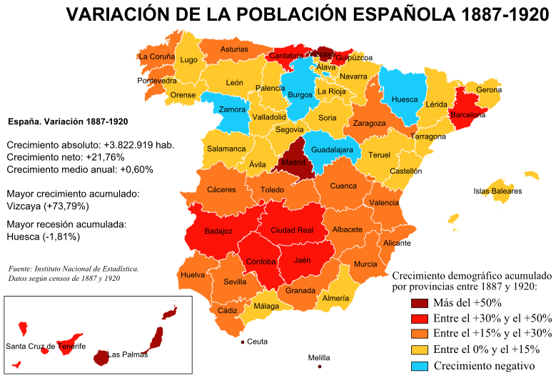
| Description | Mapa de España con las variaciones de población por provincias en el periodo 1887-1920, según los censos correspondientes del Instituto Nacional de Estadística. |
| Date | |
| Source | Instituto Nacional de Estadística de España Image:Evolución Población Provincias España 1787 - 1900.pdf[1] |
| Author | Creado por Rodriguillo, tomando como mapa base Image:Provinces of Spain.svg, creado por Emilio Gómez Fernández |
| Permission (Reusing this file) |
GFDL |
| Other versions | Image:Variación de la población española entre 1887 y 1920.svg |
| This work has been released into the public domain by its author, Rodriguillo. This applies worldwide. In some countries this may not be legally possible; if so: |
File history
Click on a date/time to view the file as it appeared at that time.
| Date/Time | Thumbnail | Dimensions | User | Comment | |
|---|---|---|---|---|---|
| current | 00:40, 30 August 2007 | | 779 × 529 (177 KB) | Rodriguillo (talk | contribs) | |
| 00:39, 23 August 2007 |  | 779 × 529 (174 KB) | Rodriguillo (talk | contribs) | {{Information |Description= Mapa de España con las '''variaciones de población''' por provincias en el periodo 1887-1920, según los censos correspondientes del Instituto Nacional de Estadística. |Source= Instituto Nacional de Estadística de Esp |
You cannot overwrite this file.
File usage on Commons
There are no pages that use this file.
File usage on other wikis
The following other wikis use this file:
- Usage on es.wikipedia.org