File:View of Dry Dock No. 4 showing double-docking of two US Navy frigates (8-66). Photographer unknown. - Hunters Point Naval Shipyard, Drydock No. 4, San Francisco, San HAER CAL,38-SANFRA,195A-14.tif
Jump to navigation
Jump to search

Size of this JPG preview of this TIF file: 763 × 600 pixels. Other resolutions: 306 × 240 pixels | 611 × 480 pixels | 977 × 768 pixels | 1,280 × 1,006 pixels | 2,560 × 2,012 pixels | 5,000 × 3,929 pixels.
Original file (5,000 × 3,929 pixels, file size: 18.74 MB, MIME type: image/tiff)
Captions
Captions
Add a one-line explanation of what this file represents
Summary[edit]
| View of Dry Dock No. 4 showing double-docking of two US Navy frigates (8-66). Photographer unknown. - Hunters Point Naval Shipyard, Drydock No. 4, San Francisco, San Francisco County, CA | ||||
|---|---|---|---|---|
| Title |
View of Dry Dock No. 4 showing double-docking of two US Navy frigates (8-66). Photographer unknown. - Hunters Point Naval Shipyard, Drydock No. 4, San Francisco, San Francisco County, CA |
|||
| Description |
U.S. Navy ships under repair at the Hunters Point Naval Shipyard in August 1966. The aircraft carrier USS Hancock (CVA-19) is to the left while the destroyers USS Preston (DD-795) and USS Edson (DD-946) are in Dry Dock No. 4, USS Enterprise (CVAN-65) is visible to the right. |
|||
| Depicted place | California; San Francisco County; San Francisco | |||
| Date | August 1966 | |||
| Dimensions | 4 x 5 in. | |||
| Current location |
Library of Congress Prints and Photographs Division Washington, D.C. 20540 USA http://hdl.loc.gov/loc.pnp/pp.print |
|||
| Accession number |
HAER CAL,38-SANFRA,195A-14 |
|||
| Credit line |
|
|||
| Source | https://www.loc.gov/pictures/item/ca2272.photos.182972p | |||
| Permission (Reusing this file) |
|
|||

| Camera location | | View this and other nearby images on: OpenStreetMap |
|---|
File history
Click on a date/time to view the file as it appeared at that time.
| Date/Time | Thumbnail | Dimensions | User | Comment | |
|---|---|---|---|---|---|
| current | 07:52, 6 July 2014 | 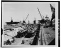 | 5,000 × 3,929 (18.74 MB) | Fæ (talk | contribs) | GWToolset: Creating mediafile for Fæ. HABS 05 July 2014 (401:500) |
You cannot overwrite this file.
File usage on Commons
The following page uses this file: