File:View of IBM digital computer model 7090 magnet core installation. ITT Artic Services, Inc., Official photograph BMEWS Site II, Clear, AK, by unknown photographer, 17 September 1965. HAER AK-30-A-98.tif
Jump to navigation
Jump to search

Size of this JPG preview of this TIF file: 485 × 600 pixels. Other resolutions: 194 × 240 pixels | 388 × 480 pixels | 621 × 768 pixels | 828 × 1,024 pixels | 1,656 × 2,048 pixels | 4,334 × 5,359 pixels.
Original file (4,334 × 5,359 pixels, file size: 22.15 MB, MIME type: image/tiff)
Captions
Captions
Add a one-line explanation of what this file represents
Summary[edit]
| Title |
View of IBM digital computer model 7090 magnet core installation. ITT Artic Services, Inc., Official photograph BMEWS Site II, Clear, AK, by unknown photographer, 17 September 1965. BMEWS, clear as negative no. A-6606. - Clear Air Force Station, Ballistic Missile Early Warning System Site II, One mile west of mile marker 293.5 on Parks Highway, 5 miles southwest of Anderson, Anderson, Denali Borough, AK |
|||
| Depicted place | Alaska; Denali Borough; Anderson | |||
| Medium | 4 x 5 in. | |||
| Current location |
Library of Congress Prints and Photographs Division Washington, D.C. 20540 USA http://hdl.loc.gov/loc.pnp/pp.print |
|||
| Accession number |
HAER AK-30-A-98 |
|||
| Credit line |
|
|||
| Source | https://www.loc.gov/pictures/item/ak0486.photos.193583p | |||
| Permission (Reusing this file) |
|

| Camera location | | View this and other nearby images on: OpenStreetMap |
|---|
File history
Click on a date/time to view the file as it appeared at that time.
| Date/Time | Thumbnail | Dimensions | User | Comment | |
|---|---|---|---|---|---|
| current | 23:21, 26 June 2014 | 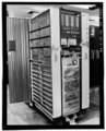 | 4,334 × 5,359 (22.15 MB) | Fæ (talk | contribs) | GWToolset: Creating mediafile for Fæ. HABS batch upload restart 26 June 2014 (p21:101)x |
You cannot overwrite this file.
File usage on Commons
The following page uses this file: