File:Vilagelsofrengesterkep470.jpg
Jump to navigation
Jump to search
No higher resolution available.
Vilagelsofrengesterkep470.jpg (470 × 267 pixels, file size: 166 KB, MIME type: image/jpeg)
Captions
Captions
Add a one-line explanation of what this file represents
Summary[edit]
| Description |
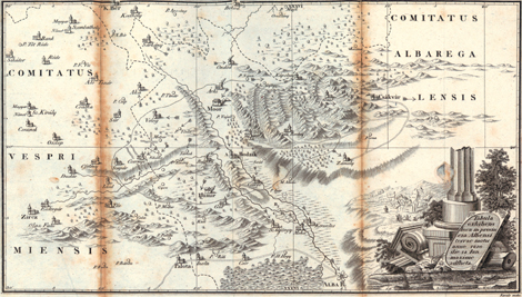
Magyar: A világ első földrengéstérképe, mely az 1810-es móri földrengést ábrázolja. English: The first earthquake map of the world (1810 Mór earthquke, Hungary). |
| Date | |
| Source | [1] |
| Author | Kitaibel Pál, Tomcsányi Ádám |
![[1]](http://www.afoldgomb.hu/images/stories/hirek/vilagelsofrengesterkep470.jpg)
Licensing[edit]
|
This work is in the public domain in its country of origin and other countries and areas where the copyright term is the author's life plus 100 years or fewer. | |
| This file has been identified as being free of known restrictions under copyright law, including all related and neighboring rights. | |
File history
Click on a date/time to view the file as it appeared at that time.
| Date/Time | Thumbnail | Dimensions | User | Comment | |
|---|---|---|---|---|---|
| current | 13:25, 14 December 2011 | | 470 × 267 (166 KB) | Einstein2 (talk | contribs) |
You cannot overwrite this file.
File usage on Commons
There are no pages that use this file.
File usage on other wikis
The following other wikis use this file:
- Usage on hu.wikipedia.org