File:Zinospetrelrangemap.png
Jump to navigation
Jump to search

Size of this preview: 699 × 600 pixels. Other resolutions: 280 × 240 pixels | 560 × 480 pixels | 1,000 × 858 pixels.
Original file (1,000 × 858 pixels, file size: 57 KB, MIME type: image/png)
Captions
Captions
Add a one-line explanation of what this file represents

|
This map image could be re-created using vector graphics as an SVG file. This has several advantages; see Commons:Media for cleanup for more information. If an SVG form of this image is available, please upload it and afterwards replace this template with
{{vector version available|new image name}}.
It is recommended to name the SVG file “Zinospetrelrangemap.svg”—then the template Vector version available (or Vva) does not need the new image name parameter. |
Summary[edit]
| Description |
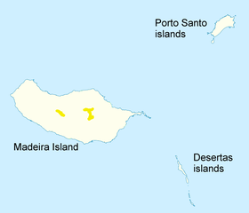
English: Range map for Pterodroma madeira
Geographische Begrenzung der Karte: * N: 33.16° N * S: 32.38° N * W: 17.31° W * O: 16.23° W Geographic limits of the map: * N: 33.16° N * S: 32.38° N * W: 17.31° W * E: 16.23° W |
| Date | (UTC) |
| Source | Own work based on: Portugal Madeira location map.svg + BirdLife International Species factsheet: Pterodroma madeira. BirdLife International. Retrieved on 24 July 2010. |
| Author |
|
| Other versions |
|

| This is a retouched picture, which means that it has been digitally altered from its original version. Modifications: boundaries removed, range added, text. The original can be viewed here: Portugal Madeira location map.svg:
|
I, the copyright holder of this work, hereby publish it under the following license:
This file is licensed under the Creative Commons Attribution-Share Alike 2.0 Generic license.
- You are free:
- to share – to copy, distribute and transmit the work
- to remix – to adapt the work
- Under the following conditions:
- attribution – You must give appropriate credit, provide a link to the license, and indicate if changes were made. You may do so in any reasonable manner, but not in any way that suggests the licensor endorses you or your use.
- share alike – If you remix, transform, or build upon the material, you must distribute your contributions under the same or compatible license as the original.
Original upload log[edit]
This image is a derivative work of the following images:
- File:Portugal_Madeira_location_map.svg licensed with Cc-by-sa-2.0
- 2009-12-19T15:41:01Z NordNordWest 1590x1365 (105588 Bytes) == {{int:filedesc}} == {{Information |Description= {{de|Positionskarte von [[:de:Madeira|Madeira]], [[:de:Portugal|Portugal]]}} Geographische Begrenzung der Karte: * N: 33.16° N * S: 32.38° N * W: 17.31° W * O: 16.23° W {
Uploaded with derivativeFX
File history
Click on a date/time to view the file as it appeared at that time.
| Date/Time | Thumbnail | Dimensions | User | Comment | |
|---|---|---|---|---|---|
| current | 09:08, 24 July 2010 | | 1,000 × 858 (57 KB) | Jimfbleak (talk | contribs) | {{Information |Description=Range map for ''Pterodroma madeira'' based on {{cite web | title = BirdLife International Species factsheet: '' Pterodroma madeira'' | author= | publisher =BirdLife International | url = http://www.birdlife.org/datazone/spe |
You cannot overwrite this file.
File usage on Commons
The following 3 pages use this file:
File usage on other wikis
The following other wikis use this file:
- Usage on ar.wikipedia.org
- Usage on arz.wikipedia.org
- Usage on bg.wikipedia.org
- Usage on ca.wikipedia.org
- Usage on cy.wikipedia.org
- Usage on de.wikipedia.org
- Usage on en.wikipedia.org
- Usage on eo.wikipedia.org
- Usage on es.wikipedia.org
- Usage on eu.wikipedia.org
- Usage on fa.wikipedia.org
- Usage on fi.wikipedia.org
- Usage on fr.wikipedia.org
- Usage on hr.wikipedia.org
- Usage on nl.wikipedia.org
- Usage on no.wikipedia.org
- Usage on pt.wikipedia.org
- Usage on sr.wikipedia.org
- Usage on sv.wikipedia.org
- Usage on uk.wikipedia.org
- Usage on vi.wikipedia.org
- Usage on www.wikidata.org
- Usage on zh.wikipedia.org