File:Map of Sealand.svg

Original file (SVG file, nominally 600 × 613 pixels, file size: 115 KB)
Captions
Captions
Info from Image:Map of Sealand.png
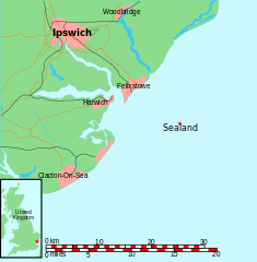
Map of Sealand
This is a map of the coast of England near Ipswich, showing the location of Sealand. The boundaries of the territorial water of the United Kingdom are also drawn, both the 3 nautical mile limit (5.556km) before 1987 and the 12nm limit (22.22km) after 1987. The same radii are also given around Sealand.
Note that these boundaries are derived based on the circular distance from the coastline, and not copied from official maps. This map is not suitable for navigation or for determining the boundaries of the UK territorial waters for legal or other purposes.
- A map with territorial water info can be found at Image:Map of Sealand with territorial waters.svg
- A vector graphic file can be found at Image:Map of Sealand with territorial waters.svg
- The OpenOffice.org source file can be found at Image:Map of Sealand with territorial waters.sxd
Map generated by DEMIS World Map Server[dead link] and edited by Chris 73
| Licensing:
This image was created by Chris 73. The image is licensed under a dual license; please choose either of the two licenses below as desired. Attribution to Wikipedia or another project of the Wikimedia foundation is required for both licenses if the image is used outside of projects of the Wikimedia foundation. Attribution to me is not required.
This file is licensed under the Creative Commons Attribution-Share Alike 3.0 Unported license. Attribution: Chris 73 / Wikimedia Commons
"I want to use the image. How do I do that?" You can use this image freely for any purpose, including commercial use, provided that you license it under one of the above licenses. My suggestion is to use the following text:
For privacy reasons please use only "Chris 73" as author. If necessary, please translate the text in your language. For electronic use please include the links in the text as shown, for printed use please print the text as shown. If you use the image I would appreciate it if you would let me know on my talk page, but this is not required as long as you follow one of the above licenses. |

File history
Click on a date/time to view the file as it appeared at that time.
| Date/Time | Thumbnail | Dimensions | User | Comment | |
|---|---|---|---|---|---|
| current | 07:57, 24 August 2011 | | 600 × 613 (115 KB) | Cwbm (commons) (talk | contribs) | maybe now |
| 07:52, 24 August 2011 |  | 600 × 613 (115 KB) | Cwbm (commons) (talk | contribs) | removed links to images | |
| 05:56, 25 March 2007 |  | 600 × 613 (115 KB) | Indolences (talk | contribs) | clean up code | |
| 04:10, 20 December 2006 |  | 600 × 613 (170 KB) | Indolences (talk | contribs) | ||
| 04:01, 20 December 2006 |  | 600 × 613 (170 KB) | Indolences (talk | contribs) | Map of Sealand This is a map of the coast of England near Ipswich, showing the location of Sealand. The boundaries of the territorial water of the United Kingdom are also drawn, both the 3 nautical mile limit (5.556km) before 1987 and the 12nm limit (22. |
You cannot overwrite this file.
File usage on Commons
There are no pages that use this file.