File:Slave and Free States before the American Civil War.svg

From Wikimedia Commons, the free media repository
Jump to navigation Jump to search

Original file(SVG file, nominally 882 × 553 pixels, file size: 105 KB)
Captions

Captions

Add a one-line explanation of what this file represents
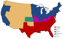
Description Free and Slave States in the period leading to the American Civil War. Free states are blue, slave states in red. Territories are a neutral yellow.
Date
Source Based on Image:US_Secession_map_1865.svg with information from en:Image:Freeandslavestates.gif
Author Self-made from public domain work Image:US_Secession_map_1865.svg
Permission
(Reusing this file)
Public domain
This work is based on a work in the public domain. It has been digitally enhanced and/or modified. This derivative work has been (or is hereby) released into the public domain by its author, Adam Cuerden. This applies worldwide.

In some countries this may not be legally possible; if so:

Adam Cuerden grants anyone the right to use this work for any purpose, without any conditions, unless such conditions are required by law.
Other versions
With details on which side they were on in the Civil War.

File history

Click on a date/time to view the file as it appeared at that time.

Date/TimeThumbnailDimensionsUserComment
current23:05, 27 September 2007Thumbnail for version as of 23:05, 27 September 2007882 × 553 (105 KB)Adam Cuerden (talk | contribs)Fixed the borders in th e territories by muckin' 'em around.
22:59, 27 September 2007Thumbnail for version as of 22:59, 27 September 2007882 × 553 (104 KB)Adam Cuerden (talk | contribs){{Information |Description= |Source= Based on Image:US_Secession_map_1865.svg with information from en:Image:Freeandslavestates.gif |Date=2007 |Author=Self-made from public domain work Image:US_Secession_map_1865.svg |Permission={{PD-retouc

File usage on other wikis

The following other wikis use this file: