User:Mattes/Contributions/Gallery of data/010
< User:Mattes | Contributions
PAGE TEN: Maps
- excluding airports, includes Title pages and cartouches and land survey
| monitoring |
| |
| Kategorien-Zuweisungen |
n files on display here
Deutschland[edit]
-
 GER — Bayern — Schwaben — Augsburg — Im Annahof 2 — 1. OG (St. Anna · Museum Lutherstiege · Route von Wittenberge nach Augsburg) — Luther kam Anno 1518 nach 12 Tagen zu Fuß und 797,4 Kilometern nach Augsburg
 -
 Pfeiffer, R. — Plan von Giesing — 1881
 -
 Die Grenzen der Herrschaft Hohenaschau gegen Tirol um 1570 (Prientalmuseum)
 -
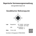
 Geodätischer Referenzpunkt in Friedrichshafen
 -
 Bad Säckingen — „Grenzpunkt“ (Zementblock, überwiegend in das Erdreich eingelassen)
 -
 Ansbach
 -
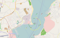 OpenSeaMap Kiel Fjord
 -
 Urpositionsplan Kgr. Bayern, Detail Giesinger Oberfeld — 1856
 -
 Altersheim St. Martin (München) — Luftbild und Parzellarkarte
 -
 Mautstraße Jachenau — Karte (OSM) 2019
 -
 Mautstraße Rottach-Egern bis Valepp — Karte OSM
 -
 Mautstraße Wallgau ↔ Vorderriß — Verlauf OSM
 -
 1936 Summer Olympics Reichssportfeld map
 -
 BY – Oberbayern — Landkreis Altötting — Burghausen — Burg
 -
 BY – Oberbayern — Landkreis Rosenheim — Fraueninsel · OSM-Karte
 -
 BY – Schwaben — Landkreis ... — Schwansee (OSM-Karte)
 -
 Delkeskamp, Friedrich W., Panorama des Rheins - Sinzig
 -
 Gebiet (Landhege) mit Dörfern der Freien Reichsstadt Rothenburg o.d.T. 1274-1802
 -
 Rügenkarte-Lubinus
 -
 OSM-Karte mit dem Leuchtturm in Lübeck-Travemünde 2021
 -
 AUT — Tirol — Bezirk Schwaz — Stadt Schwaz — Burggasse 55 (Burg Freundsberg — Stadtansicht 1556)
 -
 Stadtplan Ingolstadt im Jahre 1816
 -
 ...
... -
 ...
... -
 GER — BY — OBB — Lkr. BGL — Bad Reichenhall — Königlicher Kurgarten (Orientierungsplan)
 -
 Würzburg — Rathaus Heidingsfeld — Luftbild mit überlagerter Parzellarkarte
 -
 Referenzplatte GRP - Würzburg
_%E2%80%94_Mattes_2022-10-23.jpg)

_Mattes_Huawei_P30_Pro_2021.jpg)
_2021.jpg)
.JPG)
.JPG)


_%E2%80%94_Luftbild_und_Parzellarkarte.jpg)
_2019.png)


_Mattes_2023-04-19.jpg)
_OSM-Karte_2023_%E2%80%94_uploaded_by_Mattes.jpg)


_mit_D%C3%B6rfern_der_Freien_Reichsstadt_Rothenburg_o.d.T._1274-1802.JPG)


.jpg)
_Mattes_2022-02-26.jpg)
_%E2%80%94_Mattes_2022-02-25_Batch_(22).jpg)
_%E2%80%94_Mattes_2022-02-25_Batch_(23).jpg)
_%E2%80%94_Mattes_2022-04-17.jpg)

Österreich[edit]
-

-
 AUT — Bundesland Salzburg — Salzburg (Stadt) — Getreidegasse 9 (Mozartmuseum — Reiseziele des W.A. Mozart)
.JPG)
_%E2%80%94_Getreidegasse_9_(Mozartmuseum_%E2%80%94_Reiseziele_des_W.A._Mozart)_Mattes_2021.jpg)
Sonst.[edit]
-
 Atlas minor praecipua orbis terrarum imperia, Regna et Provincias (title page)
 -
 World Map of Continents and Oceans (1700)
 -
 Karte aus Zweigen - Marshallinseln
 -
 Urbano Monti — World map as of 1587
 -
 Johnson B. — A Map of the Various Paths of Life — 1805
 -
 Lindau (Bodensee) (Geodätischer Referenzpunkt)
 -
 Plan de Téléphérique de l'Aiguille du Midi 2018
 -
 Buache, Philippe — Planisphere Physique ou l'on voit du Pole Septentrional ce que l'on connoit de Terres et de Mers Avec les —Grandges Chaines de Montagnes qui traversant le Globe… 1750
 -
 Das Reich der Liebe Zweyter Landchartensatz-Versuch
 -
 Bünting, Heinrich — Asia Secunda Pars Terrae in Forma Pegasi
 -
 Schedelsche Weltchronik — Secuda etas mundi — Folio 12v
 -
 Schedelsche Weltchronik — Secuda etas mundi — Folio 12v 13r
 -
Antique World Map of Continents and Oceans · 1700
-
 OpenSeaMap Mumbai Harbour 2021
 -
 OpenSeaMap Mumbai Bay 2021
 -
 Charte von Ostindien nach I. Rennel. Gebrüder Lotter — between 1777 and 1810
 -
 Bourgoin, Pierre — Mappe Monde Carte Universelle 1766
 -
 Faden, William — A map of Bengal, Bahar, Oude & Allahabad — Detail cartouche
 -
 Faden, William — Map of Switzerland 1799 — Detail cartouche
 -
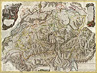 Faden, William — Map of Switzerland 1799
 -
 Hondius, Henricus 2 Title Page Italiae Sclavoniae, Et Graeciae tabula geographice, Per Gerardum Mercatorem...
 -
 Atlas Cosmographicæ (Mercator)
 -
 Mercator Title Page Atlas Sive Cosmographicae Meditationes De Fabrica Mundi et Fabricati Figura ... 1619
 -
 Schouten and Blaeu Untitled Map - Double Hemisphere Map with Portraits of Magellan, Schoten, Drake, Von Noort, Cavendish, and Speilbergen c. 1618
 -
 GMG45 4 B&H 3 1593
 -
 Map of Greece, Archipelago and part of Anadoli; Louis Delarochette 1791 — Detail cartouche
 -
 Gracie Emmett in her great play the Pulse of New York
 -
 Jefferys, Thomas — The Provinces of New York, and New Jersey; with part of Pennsilvania, and the Province of Quebec – Detail Cartouche
 -
 Aero view of Hammonton, New Jersey 1926
 -
 Cook, James — Map of the Province of South Carolina 1773
 -
 Cook, James — A Map of the Province of South Carolina 1773 — Detail cartouche
 -
 Trade card of Thomas Jeffreys 1750
 -
 Jefferys, Thomas — The Western Coast of Africa from Cape Blanco to Cape Virga, Exhibiting Senigambia Proper.
 -
 Jefferys, Thomas — The Western Coast of Africa from Cape Blanco to Cape Virga, Exhibiting Senigambia Proper — Detail cartouche
 -
 Didier and Gilles Robert de Vaugondy — La Chine 1751
 -
 Didier and Gilles Robert de Vaugondy — L'Empire de la Chine, Dresse d'apres les cartes de l'Atlas Chinois; Detail Cartouche
 -
 Vaugondy, Gilles Robert De — Orbis Vetus in utraque continente juxta mentem Sansonianam distinctus, nec non observationibus astonimicis redactus 1752
 -
 Mori, Daniele — Allégorie de la vie humaine visible autrefois en Grèce à l'entrée du temple de Saturne — 1525 - 1550
 -
 Lisle, Guillaume de — Carte du Canada ou de la Nouvelle France et des decouvertes que y ont ete faites... — detail cartouche
 -
 Per I. Bormeester Exc.
 -
 Sanson Map of the World on Hemisphere Projection — Detail bottom center
 -
 Havana, Cuba Map 1898
 -
 Bessarabia ethnographical map 1919
 -
 Maggiolo, Vesconte — BSB Cod.icon. 135 — Afrika Bsb00002700 00003
 -
 Fernão Vaz Dourado — Karte 2 Südamerika nördl. — BSB-Hss Cod.icon. 137 — Abb. 16
 -
 Liber chronicarum Gottvater Bsb00034024 00073
 -
 Liber chronicarum Donnerstein von Ensisheim (upper illustration)
 -
 Planisphaerium coeleste. A.C. Seutter delin. Andr. Silbereisen Sculps (world map 1744)
 -
Atlas minor praecipua orbis terrarum imperia, Regna et Provincias (title page)
-
 Sacri Romani imperii circuli et electoratus Bavariæ tabula chorographica (1663)
 -
 East Numidia
 -
 Whidbey Island
 -
 Intrborderstates
 -
 Map of New York highlighting Nassau County
 -
 Contour map of Dixon Entrance
 -
 WAMap-doton Yakima WA
 -
 Wpdms_nasa_topo Gulf of Maine
 -
 Viñeta del mapa de Waldseemüller
 -
 NWCoast1a
 -
Cape Meares
-

-
 SaipanTinianAquijan
 -
 Christian_Nubia
 -
 Wpdms_shdrlfi020l_upper_klamath_lake
 -
 Mannados
 -
 elixstowe - Suffolk dot
 -
 Brescia_dot
 -
 Beaufort_Sea_and_disputed_waters
 -
 Wpdms nasa topo green river utah
 -
 Nova_Orbis_Tabula_in_Lucem_Edita
 -
 Columbia
 -
 Wpdms nasa topo columbia river gorge
 -
 Hyderabad
 -
 US regions-Southeast
 -
 WAMap-doton-Leavenworth, WA
 -
 ORMap-doton-Mount Vernon
 -
 What happened with my file (DEL + new upload)?
 -
 AKMap-doton-Cordova
 -
 ORMap-doton Odell OR
 -
 ORMap-doton Parkdale OR
 -
 Quebec-septiles
 -
 Abkhazia_detail_map
 -
 Nt-map
 -
 Darjeeling
 -
 Forterie-niagara
 -
 USA_2000_asian_density
 -
 Dharamsala_indien
 -
 Ph_locator_negros_occidental_bago
 -
 ORMap-doton-Clackamas OR
 -
 ORMap-doton-Tillamook OR
 -
 WAMap-doton-Bingen OR
 -
 Mare_Tranquillitatis (eartly moon)
 -
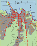 city of Apia, Samoa
 -
 US state abbrev map
 -
 WAMap-doton-Point_Roberts WA
 -
 WAMap-doton-Port_Angeles
 -
 Hood River, OR
 -
 Wpdms_nasa_topo_oregon_trail
 -
 Mount Vernon
 -
 Map-of-washington-state-showing-puget-sound-area
 -
 Wpdms topo_olympic_peninsula (NASA)
 -
 Vancouver island relief
 -
 ORMap doton Pendleton OR
 -
 NDMap-doton-Grand Forks
 -
 Pacnorwest
 -
 Kitsapcounty, Wash.
 -
 Tiksi - Siberia - Laptev Sea
 -
 New Siberian Islands
 -
 Calais_dot
 -
 HongKong Asia-Pacific Latitude
 -
 Nordic_Bronze_Age
 -
 Tapa_in_Estonia
 -
Map-of-washington-state-showing-puget-sound-area
-
 Wpdms nasa topo missoula floods
 -
 Map of Alaska highlighting Prince of Wales Island
 -
 Selangor
 -
 Geologic map of Crater Lake floor
 -
 Würzburg — Rathauskomplex — Luftbild mit überlagerter Parzellarkarte
 -
 Johann Gottfried Herder — Besuchte Orte während der Italienreise 1788 bis 1789
 -
 Stendhal — Besuchte Orte während der Italienreise 1817
 -
 Lewald, Fanny — Besuchte Orte während der Italienreise 1845 bis 1846 (Karte)
 -
 Vancouver
 -
Camp_Fistclench_Layout_plan_USACE_1965
-
Camp_Century_Layout_plan_USACE,_fig._26,_p._34
.jpg)


_%E2%80%93_Lindau_(Bodensee)_%E2%80%93_Insel_%E2%80%93_Haupthafen_(Geod%C3%A4tischer_Referenzpunkt).JPG)


.jpg)


_107.jpg)


.jpg)
.jpg)
.jpg)


.jpg)
.JPG)
.jpg)

... Part 9 (Animals and plants)
User Mateus2019 🌫 Mattes

··· navAID ···
|
… show sub-pages … ⋙====► |
|---|
Main category: User:Mattes/Contributions
|
- ➢ Personal usage
- ➢➢ Studies
|
… show sub-pages … ⋙====► |
|---|
- ➢➢ Projects
|
… show sub-pages … ⋙====► |
|---|
