User:Peripitus/Gallery/Maps and constructs
Jump to navigation
Jump to search

Quality • • Unsorted • • Maps and Constructs • • Adelaide • • South Australia • • Lebanon • • Flora • • Fauna • • Misc
-
 Catchment of the River Torrens
 -
 Extent of the Adelaide lectric Tram network
 -
 Extent of the horse tram network in Adelaide
 -
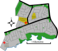
 layout of the suburb of St Kilda, South Australia
 -
 Really bad graph of population decline in Beltana, South Australia
 -
 Streetmap of Para Hills, South Australia including the changes from 2002 when some became part of Gulfview Heights
 -
 North Adelaide and Adelaide showing the Torrens + rail and tram lines
 -
 Rymill Park on the east side of adelaide, part of the adelaide parklands
 -
 Elizabeth Vale, South Australia streetmap.
 -
 Adelaide suburban area
 -
 Port Road in Adelaide
 -
 Anzac highway in Adelaide
 -
 Grand junction Road in Adelaide
 -
 Cobbler Creek recreation park
 -
 Anstey Hill recreation park
 -
 Map of Cleland Conservation park in the foothills of the Mount Lofty Ranges, South Australia


