User talk:Spesh531
|
Our first steps tour and our FAQ will help you a lot after registration. They explain how to customize the interface (for example the language), how to upload files and our basic licensing policy. You don't need technical skills in order to contribute here. Be bold contributing here and assume good faith for the intentions of others. This is a wiki—it is really easy. More information is available at the community portal. You may ask questions at the help desk, village pump or on IRC channel #wikimedia-commons (direct access). You can also contact an administrator on their talk page. If you have a specific copyright question, ask at Commons talk:Licensing. |
| |
| (P.S. Would you like to provide feedback on this message?) | ||
Tip: Categorizing images[edit]

Thanks a lot for contributing to the Wikimedia Commons! Here's a tip to make your uploads more useful: Why not add some categories to describe them? This will help more people to find and use them.
Here's how:
1) If you're using the UploadWizard, you can add categories to each file when you describe it. Just click "more options" for the file and add the categories which make sense:

2) You can also pick the file from your list of uploads, edit the file description page, and manually add the category code at the end of the page.
[[Category:Category name]]
For example, if you are uploading a diagram showing the orbits of comets, you add the following code:
[[Category:Astronomical diagrams]][[Category:Comets]]
This will make the diagram show up in the categories "Astronomical diagrams" and "Comets".
When picking categories, try to choose a specific category ("Astronomical diagrams") over a generic one ("Illustrations").
Thanks again for your uploads! More information about categorization can be found in Commons:Categories, and don't hesitate to leave a note on the help desk.BotMultichillT 06:15, 2 August 2009 (UTC)
- Image:World map changes 08-1-8.png is uncategorized since 1 August 2009.
- Image:World map changes 08-17-2.png is uncategorized since 1 August 2009.
- Image:Vietnam province merge.png was uncategorized on 4 September 2009.
- Image:Russia krai new.png was uncategorized on 4 September 2009.
- Image:Myanmar 2005.png was uncategorized on 5 September 2009.
- Image:World map changes 02-6-20.png was uncategorized on 5 September 2009.
- Image:India Calcutta-Kolkata 2001.png was uncategorized on 5 September 2009.
- Image:Palau Capital Change.png was uncategorized on 5 September 2009.
- Image:Michel-Ange Houasse 001.png was uncategorized on 23 November 2009 CategorizationBot (talk) 11:17, 24 November 2009 (UTC)
- Image:Charles III of Spain.png was uncategorized on 23 November 2009 CategorizationBot (talk) 11:17, 24 November 2009 (UTC)
- Image:Votes for Wiktionary Round 1.png was uncategorized on 29 December 2009 CategorizationBot (talk) 10:54, 30 December 2009 (UTC)
- Image:60% Chart.png was uncategorized on 2 January 2010 CategorizationBot (talk) 10:53, 3 January 2010 (UTC)
- Image:Logo 15 in wiktionary vote round 1.png was uncategorized on 10 January 2010 CategorizationBot (talk) 10:53, 11 January 2010 (UTC)
- Image:Test File.svg was uncategorized on 14 August 2011 CategorizationBot (talk) 12:07, 15 August 2011 (UTC)
- Image:Coat of Arms of the Prince-Bishopric of Montenegro.svg was uncategorized on 30 October 2011 CategorizationBot (talk) 12:17, 31 October 2011 (UTC)
- Image:Senegambia (orthographic projection).svg was uncategorized on 22 November 2011 CategorizationBot (talk) 15:07, 23 November 2011 (UTC)
File source is not properly indicated: File:Bassaki Penninsula Change.png[edit]
| This media was probably deleted. |
A file that you have uploaded to Wikimedia Commons, File:Bassaki Penninsula Change.png, was missing information about where it comes from or who created it, which is needed to verify its copyright status. The file probably has been deleted. If you've got all required information, request undeletion providing this information and the link to the concerned file (
[[:File:Bassaki Penninsula Change.png]]).
If you created the content yourself, enter If someone else created the content, or if it is based on someone else's work, the source should be the address to the web page where you found it, the name and ISBN of the book you scanned it from, or similar. You should also name the author, provide verifiable information to show that the content is in the public domain or has been published under a free license by its author, and add an appropriate template identifying the public domain or licensing status, if you have not already done so. Warning: Wikimedia Commons takes copyright violations very seriously and persistent violators will be blocked from editing. Please add the required information for this and other files you have uploaded before adding more files. If you need assistance, please ask at the help desk. Thank you! |
-- ■ MMXXtalk 03:40, 6 September 2009 (UTC)
 |
File:Bassaki Penninsula Change.png has been marked as a possible copyright violation. Wikimedia Commons only accepts free content—that is, images and other media files that can be used by anyone, for any purpose. Traditional copyright law does not grant these freedoms, and unless noted otherwise, everything you find on the web is copyrighted and not permitted here. For details on what is acceptable, please read Commons:Licensing. You may also find Commons:Copyright rules useful, or you can ask questions about Commons policies at the Commons:Help desk. If you are the copyright holder and the creator of the file, please read Commons:But it's my own work! for tips on how to provide evidence of that.
The file you added has been deleted. If you have written permission from the copyright holder, please have them send us a free license release via COM:VRT. If you believe that the deletion was not in accordance with policy, you may request undeletion. (It is not necessary to request undeletion if using VRT; the file will be automatically restored at the conclusion of the process.) Warning: Wikimedia Commons takes copyright violations very seriously and persistent violators will be blocked from editing.
|
Same goes for File:World map changes 06-14-8.png. Also note: name is Bakassi not Bassaki, change happened in 2008 not 2006. If you have based a map on a permitted source such as File:World map changes 08-17-2.png, kindly have the decency to declare the base map instead of cheekily claiming that it is "all my own work". — RHaworth (Talk | contribs) 18:15, 8 September 2009 (UTC)
|
File:IPod_5G.jpg has been marked as a possible copyright violation. Wikimedia Commons only accepts free content—that is, images and other media files that can be used by anyone, for any purpose. Traditional copyright law does not grant these freedoms, and unless noted otherwise, everything you find on the web is copyrighted and not permitted here. For details on what is acceptable, please read Commons:Licensing. You may also find Commons:Copyright rules useful, or you can ask questions about Commons policies at the Commons:Help desk. If you are the copyright holder and the creator of the file, please read Commons:But it's my own work! for tips on how to provide evidence of that.
The file you added has been deleted. If you have written permission from the copyright holder, please have them send us a free license release via COM:VRT. If you believe that the deletion was not in accordance with policy, you may request undeletion. (It is not necessary to request undeletion if using VRT; the file will be automatically restored at the conclusion of the process.) Warning: Wikimedia Commons takes copyright violations very seriously and persistent violators will be blocked from editing.
|
Denniss (talk) 22:59, 26 September 2009 (UTC)
ROC's Offical captital[edit]
Please provide citiation from ROC current laws , otherwise it will reverses to old version. Ianbu (talk) 13:24, 23 October 2010 (UTC)

|
File:BlankMap-World.png has been listed at Commons:Deletion requests so that the community can discuss whether it should be kept or not. We would appreciate it if you could go to voice your opinion about this at its entry.
If you created this file, please note that the fact that it has been proposed for deletion does not necessarily mean that we do not value your kind contribution. It simply means that one person believes that there is some specific problem with it, such as a copyright issue. Please see Commons:But it's my own work! for a guide on how to address these issues. |
SBC-YPR (talk) 07:45, 13 February 2011 (UTC)
File source is not properly indicated: File:BlankMap-World.png[edit]
| This media may be deleted. |
A file that you have uploaded to Wikimedia Commons, File:BlankMap-World.png, is missing information about where it comes from or who created it, which is needed to verify its copyright status. Please edit the file description and add the missing information, or the file may be deleted.
If you created the content yourself, enter If someone else created the content, or if it is based on someone else's work, the source should be the address to the web page where you found it, the name and ISBN of the book you scanned it from, or similar. You should also name the author, provide verifiable information to show that the content is in the public domain or has been published under a free license by its author, and add an appropriate template identifying the public domain or licensing status, if you have not already done so. Warning: Wikimedia Commons takes copyright violations very seriously and persistent violators will be blocked from editing. Please add the required information for this and other files you have uploaded before adding more files. If you need assistance, please ask at the help desk. Thank you! |
...Captain......Tälk tö me.. 08:33, 13 February 2011 (UTC)
Image:BlankMap-World.png and Southern Sudan[edit]
You did a great job adding w:Southern Sudan to Image:BlankMap-World.png! I have been trying to figure out how to draw the new country since the referendum ended. Your work will make it much easier to update various maps based on this one after independence in July. Good work~ Hoshie (talk) 11:08, 13 February 2011 (UTC)
Essential information missing at File:BlankMap-World.png[edit]
Copyright status: File:BlankMap-World.png[edit]
| This media may be deleted. |
Thanks for uploading File:BlankMap-World.png. I notice that the file page either doesn't contain enough information about the license or it contains contradictory information about the license, so the copyright status is unclear.
If you created this file yourself, then you must provide a valid copyright tag. For example, you can tag it with {{self|GFDL|cc-by-sa-all}} to release it under the multi-license GFDL plus Creative Commons Attribution-ShareAlike All-version license or you can tag it with {{PD-self}} to release it into the public domain. (See Commons:Copyright tags for the full list of license tags that you can use.) If you did not create the file yourself or if it is a derivative of another work that is possibly subject to copyright protection, then you must specify where you found it (e.g. usually a link to the web page where you got it), you must provide proof that it has a license that is acceptable for Commons (e.g. usually a link to the terms of use for content from that page), and you must add an appropriate license tag. If you did not create the file yourself and the specific source and license information is not available on the web, you must obtain permission through the VRT system and follow the procedure described there. Note that any unsourced or improperly licensed files will be deleted one week after they have been marked as lacking proper information, as described in criteria for deletion. If you have uploaded other files, please confirm that you have provided the proper information for those files, too. If you have any questions about licenses please ask at Commons:Village pump/Copyright or see our help pages. Thank you. |
File source is not properly indicated: File:BlankMap-World.png[edit]
| This media may be deleted. |
A file that you have uploaded to Wikimedia Commons, File:BlankMap-World.png, is missing information about where it comes from or who created it, which is needed to verify its copyright status. Please edit the file description and add the missing information, or the file may be deleted.
If you created the content yourself, enter If someone else created the content, or if it is based on someone else's work, the source should be the address to the web page where you found it, the name and ISBN of the book you scanned it from, or similar. You should also name the author, provide verifiable information to show that the content is in the public domain or has been published under a free license by its author, and add an appropriate template identifying the public domain or licensing status, if you have not already done so. Warning: Wikimedia Commons takes copyright violations very seriously and persistent violators will be blocked from editing. Please add the required information for this and other files you have uploaded before adding more files. If you need assistance, please ask at the help desk. Thank you! |
--SBC-YPR (talk) 15:53, 25 March 2011 (UTC)
Sudan[edit]
Hi,
I reverted your change to the Sudan map, as the partition will only occur on 9 July 2011. Still 2 weeks to go!
Cheers, Popo le Chien ouah 12:32, 29 June 2011 (UTC)
There is a same Cache-problem on File:World cup appearances.png --- Dufo (talk) 15:31, 9 July 2011 (UTC)
South Sudan location map.svg[edit]
Hello! Please don't change location maps without adjusting all templates in all projects in which they are used. With espanding the South Sudan map more to the west all towns, lakes etc. were shown at a wrong spot. NNW (talk) 07:55, 18 August 2011 (UTC)
- Nevermind my previous comment, after doing a bit more hunting, once I knew what to search on, I found the region is indeed disputed or at least could be [1], [2]. Looks like it should be South Sudan, but is de facto still North, and of course no one knows if the South will pursue the claim. A change to the maps (and templates) probably is justified. Kmusser (talk) 20:18, 18 August 2011 (UTC)
Libyan uprising-es[edit]
Ghadames is in Rebel hands. The last report about the area was this: [3]and it says that the Rebel-held city was being shelled by Loyalists. About Al Yawf/Kufra, see [4] About Mezda, see 16:56 15 August entry[5]
And, when you update the Spanish version, could you update it changing the colours of that version? Because the English and the Spanish versions are different: the size of the word Tripoli, the word Mezda in the Spanish is a bit below so that it is not confused with Zintan, etc. --Ave César Filito (talk) 15:02, 21 August 2011 (UTC)
Russian-language Libyan Uprising map[edit]
With this version you seem to have changed some of the names from Russian to Serbian (e.g. аль–Байда —> аль–Баjда). ~~ Lothar von Richthofen (talk) 04:12, 23 August 2011 (UTC)
Location greek ancient.png map[edit]
The Location greek ancient.png map is about historical Greek settlements. If a comparison of the historical Greek settlements with current countries they were situated in has to be made, they have to be shown with international de jure borders, and not disputed de facto borders and even more seriously irredentist border claims between counbtries. Nor is this about the present but about historical Greek settlements. There is no place for current politics for a historical map by showing (as well as blurred and overlapping in such a small map) border claims.
Please take this into account and re-edit this map again with internationally recognized borders. Disputed border claims appropriately have their own sections, and if there is none, create separate world and/or regional maps about irredentist border claims between countries. Keep both of these separate and again take this into account as previous users have done on this map. Maphobbyist (talk) 13:34, 3 September 2011 (UTC)
- Yes I will use the en:File:World map model.png map showing the de jure and de facto borders in the future. Your latest edition in the Location greek ancient.png map using this map as a basis is absolutley fine. I revert myself and I agree that de facto borders should also be shown, such as with Kosovo or Northern Cyprus, as long as it is not extended to irredentist border claims of countries, especially when they do not reflect the actual situation of borders.
- The problem is when overlapping irredentist border claims of countries i.e. Greater Somalia, Greater Albania etc. are also shown on maps, which do not reflect the actual situation of borders, it complicates the matter, particularly because when it is not about such a topic. That is why it is best to use the map you have recommended. Thank you for this. Maphobbyist (talk) 21:00, 5 September 2011 (UTC)
|
|
File:Flag_of_Libya_(2011).svg has been listed at Commons:Deletion requests so that the community can discuss whether it should be kept or not. We would appreciate it if you could go to voice your opinion about this at its entry.
If you created this file, please note that the fact that it has been proposed for deletion does not necessarily mean that we do not value your kind contribution. It simply means that one person believes that there is some specific problem with it, such as a copyright issue. Please see Commons:But it's my own work! for a guide on how to address these issues. |
Fry1989 eh? 00:25, 19 September 2011 (UTC)
Unfortunately the crescent shape in your uploaded version of the image doesn't look like it's an intersection of two circular or slightly-elliptical arcs. If you e-mail me, I can send you a GIF file to show what I mean. (If you encode a curve with "A" or "a" path elements, then you can ensure that all curves are circular or elliptical arcs by definition.) Also, the size of the file was bloated by 700%-800%, which is never a good sign... AnonMoos (talk) 21:14, 20 September 2011 (UTC)
- P.S. To put it another way, the 395-byte version of the file contained two arc/curve commands, while the version you uploaded contained ten! AnonMoos (talk) 21:28, 20 September 2011 (UTC)
P.S. Just noticed http://en.wikipedia.org/wiki/File:Libyan_Flag_Blueprint.png , but I don't think the file you uploaded satisfies that description (under the assumption of circular arcs)... AnonMoos (talk) 22:07, 20 September 2011 (UTC)
Now uploaded a version of File:Flag of Libya (2011).svg which mainly satisfies http://en.wikipedia.org/wiki/File:Libyan_Flag_Blueprint.png (except that I kind of had to guess at the radius of the crescent's inner circle...). -- AnonMoos (talk) 23:03, 20 September 2011 (UTC)
You open the file in a text editor and eliminate the Inkscape cruft and optimize paths by knowing what SVG code does. See User_talk:R-41#Flag_of_Iraq_1959-1963... AnonMoos (talk) 23:13, 20 September 2011 (UTC)
Spesh531, please don't revert or reupload that flag again. Even if you are right, it's not polite to do an "edition war". Use the talk page to discuss the controversial issues and then reach a consensus about them. Giro720 (talk) 23:59, 20 September 2011 (UTC)
Libyan Flag Changes[edit]
I've opened a new discussion on the Libyan flag talk page, please have a look. Jaw101ie (talk) 10:49, 25 September 2011 (UTC)
|
|
File:Flag_of_Libya_(2011).svg has been listed at Commons:Deletion requests so that the community can discuss whether it should be kept or not. We would appreciate it if you could go to voice your opinion about this at its entry.
If you created this file, please note that the fact that it has been proposed for deletion does not necessarily mean that we do not value your kind contribution. It simply means that one person believes that there is some specific problem with it, such as a copyright issue. Please see Commons:But it's my own work! for a guide on how to address these issues. |
Fry1989 eh? 19:55, 27 September 2011 (UTC)
Pay attention to licensing
|
Wikimedia Commons only accepts free content: images and other media files that can be used by anyone, for any purpose.
File:2011 Libyan Civil War.png seems to be free (or it would be proposed for deletion), but it was identified as having a wrong license. Usually, it is because a public domain image is tagged with a free license, or because the stated source or other information is not sufficient to prove the selected tag is correct. Please verify that you applied the correct license tag for this file. If you believe this file has the correct license, please explain why on the file discussion page.
|
The reason given by the user who added this tag is: Please see the file's page for more info.
→AzaToth 15:32, 9 October 2011 (UTC)
Pay attention to licensing
|
Wikimedia Commons only accepts free content: images and other media files that can be used by anyone, for any purpose.
File:2011 Libyan Civil War.png seems to be free (or it would be proposed for deletion), but it was identified as having a wrong license. Usually, it is because a public domain image is tagged with a free license, or because the stated source or other information is not sufficient to prove the selected tag is correct. Please verify that you applied the correct license tag for this file. If you believe this file has the correct license, please explain why on the file discussion page.
|
The reason given by the user who added this tag is: Please see the file's page for more info.
→AzaToth 15:42, 9 October 2011 (UTC)
|
File:Rushmore Avenue School.png has been marked as a possible copyright violation. Wikimedia Commons only accepts free content—that is, images and other media files that can be used by anyone, for any purpose. Traditional copyright law does not grant these freedoms, and unless noted otherwise, everything you find on the web is copyrighted and not permitted here. For details on what is acceptable, please read Commons:Licensing. You may also find Commons:Copyright rules useful, or you can ask questions about Commons policies at the Commons:Help desk. If you are the copyright holder and the creator of the file, please read Commons:But it's my own work! for tips on how to provide evidence of that.
The file you added has been deleted. If you have written permission from the copyright holder, please have them send us a free license release via COM:VRT. If you believe that the deletion was not in accordance with policy, you may request undeletion. (It is not necessary to request undeletion if using VRT; the file will be automatically restored at the conclusion of the process.) Warning: Wikimedia Commons takes copyright violations very seriously and persistent violators will be blocked from editing.
|
→AzaToth 23:33, 13 October 2011 (UTC)
|
File:Cherry Lane School.png has been marked as a possible copyright violation. Wikimedia Commons only accepts free content—that is, images and other media files that can be used by anyone, for any purpose. Traditional copyright law does not grant these freedoms, and unless noted otherwise, everything you find on the web is copyrighted and not permitted here. For details on what is acceptable, please read Commons:Licensing. You may also find Commons:Copyright rules useful, or you can ask questions about Commons policies at the Commons:Help desk. If you are the copyright holder and the creator of the file, please read Commons:But it's my own work! for tips on how to provide evidence of that.
The file you added has been deleted. If you have written permission from the copyright holder, please have them send us a free license release via COM:VRT. If you believe that the deletion was not in accordance with policy, you may request undeletion. (It is not necessary to request undeletion if using VRT; the file will be automatically restored at the conclusion of the process.) Warning: Wikimedia Commons takes copyright violations very seriously and persistent violators will be blocked from editing.
|
→AzaToth 23:33, 13 October 2011 (UTC)
|
|
File:Flag_of_Libya_(1951).svg has been listed at Commons:Deletion requests so that the community can discuss whether it should be kept or not. We would appreciate it if you could go to voice your opinion about this at its entry.
If you created this file, please note that the fact that it has been proposed for deletion does not necessarily mean that we do not value your kind contribution. It simply means that one person believes that there is some specific problem with it, such as a copyright issue. Please see Commons:But it's my own work! for a guide on how to address these issues. |
Fry1989 eh? 19:03, 27 October 2011 (UTC)
This message was added automatically by Nikbot, if you need some help about it please read the text above again and follow the links in it, if you still need help ask at the ![]() → Commons:Help desk in any language you like to use. --Nikbot 05:56, 26 November 2011 (UTC)
→ Commons:Help desk in any language you like to use. --Nikbot 05:56, 26 November 2011 (UTC)
|
|
File:Syrian_Civil_War.svg has been listed at Commons:Deletion requests so that the community can discuss whether it should be kept or not. We would appreciate it if you could go to voice your opinion about this at its entry.
If you created this file, please note that the fact that it has been proposed for deletion does not necessarily mean that we do not value your kind contribution. It simply means that one person believes that there is some specific problem with it, such as a copyright issue. Please see Commons:But it's my own work! for a guide on how to address these issues. |
FunkMonk (talk) 16:36, 3 December 2011 (UTC)
Hey Spesh531,
Not sure if this is the correct way to contact you but whatever. The SAA have made a few advances that need to be added to your map. Kessab and surrounding countryside has been taken by the SAA, here's a link http://www.syrianperspective.com/wp-content/uploads/2014/06/Lattakia-map.png(Pro-government website for illustration of map only, you'll find the confirmation elsewhere on pro-opposition sites too). In Northern Aleppo around the prison area there have also been advances to try and encircle the opposition fighters: http://www.syrianperspective.com/wp-content/uploads/2014/06/New-map.jpg (as above, for illustration only).
Thanks
This message was added automatically by Nikbot, if you need some help about it please read the text above again and follow the links in it, if you still need help ask at the ![]() → Commons:Help desk in any language you like to use. --Nikbot 06:20, 28 January 2012 (UTC)
→ Commons:Help desk in any language you like to use. --Nikbot 06:20, 28 January 2012 (UTC)
Somalia[edit]
Baidoa was taken, could you update the map? Thanks. —Nightstallion (?) 14:41, 22 February 2012 (UTC)
- Galgalato near Mogadishu has been taken, though that might be too small a change to show up on the map. —Nightstallion (?) 12:27, 17 March 2012 (UTC)
- El Buur (Ceelbuur on the map) was taken. —Nightstallion (?) 16:45, 27 March 2012 (UTC)
- Now Afgooye. —Nightstallion (?) 16:26, 25 May 2012 (UTC)
Somalia map states regions districts.png[edit]
Hello. I want to say you that Somalia map SVG-file is maden (work not enough). Let's edit this vector version. --Nicolay Sidorov (talk) 11:24, 12 March 2012 (UTC)
- I do not have the time to fix the map (I am trying to fix a million different things on Wikipedia and images on commons), this is really good, eventually, the .svg should be used, but I have other things I need to do. I will probably help work on it somehow anyway, but I will keep updating the .png map until there can be an agreement about using that. Great job doing the map. —Spesh531, My talk, and External links 19:55, 12 March 2012 (UTC)
File:MNLA flag.svg moving[edit]
There are just a lot of unknowns right now for the move so that is why I am asking just to wait. There has been times where Wikipedia was wrong on these symbols and any move we do affect a lot of projects. If whoever controls this new territory says "Hey, this is the flag!" and there is a source, I will gladly have it moved. I am trying to be cautious about this, so I hope you understand my reasoning in postponing the move for right now. User:Zscout370 (Return fire) 04:32, 8 April 2012 (UTC)
- Okay, I have been trying to find any sort of info on Azawad for anything, right now, it seems like a lawless country that respects its bordering countries borders. —Spesh531, My talk, and External links 05:11, 8 April 2012 (UTC)
- I am trying to also find something (but also a spec sheet, but that is immaterial to this move) that is official but the only thing I know for sure is that this flag is used on the emblem of the MNLA and has been raised in captured territory. There is a political declaration, but not much (and most of everything I found is in French). User:Zscout370 (Return fire) 05:14, 8 April 2012 (UTC)
Somalia sources[edit]
How are you determining information for File:Somalia map states regions districts.png? It's very different from the map produced by the BBC. Chipmunkdavis (talk) 17:57, 26 May 2012 (UTC)
- I have been getting sources from the info on en:2012 timeline of the war in Somalia, the sources on the page of course, and the BBC map seems off. The fact that Afgoyle was captured by TFG, it does not even show the areas on their map. The fact that Somalia is mainly desert, BBC is basing some of the territory from where the roads are, the fact their is no control from either in the remote desert areas makes it hard to show what's actually controlled. —Spesh531, My talk, and External links 03:29, 27 May 2012 (UTC)
Orthographic colours[edit]
With regards to your recent changes to some orthographic maps, the guidelines on the page and those that have existed in reality are quite different. The standard is currently the dark grey countries with white borders. That said, the dark greys aren't perfect either. What do you think about a combination of sorts, with a slightly darker countries, to help distinguish them from water when in thumbnails, but done with black borders? (I've had a similar discussion on my/theotheruser's talkpage(s) before, if you're interested in a read over. Didn't come to much in the end.) As an aside, how are you making the changes? If it's simple enough, I could be of some help, unless you feel like changing every orthographic map yourself :) Chipmunkdavis (talk) 12:15, 19 July 2012 (UTC)
- I have been using the colors from here: Wikipedia:WikiProject_Maps/Conventions/Orthographic_maps. I am not sure otherwise (I obviously have no control over the conventions). I have been using inkscape, although I have stopped. I believe inkscape makes the file bigger, and I do not know of another free program that is better. I have been making the maps by using File:Africa (orthographic projection).svg as a basis for the African maps. I move the shade in the front, remove the green continent, and under it is the gray like surrounding countries. I then outline the country for the file, and put the shade back. —Spesh531, My talk, and External links 14:04, 19 July 2012 (UTC)
- Yes, I saw in your thorough upload summary. You've got as much control over the conventions as any editor, which is the ability to start discussion. Quite obviously the current conventions haven't been followed at all. I would say the convention should follow what is done, rather than the other way around. I'm unaware that inkscape increases file size, it's my usual tool as well. Chipmunkdavis (talk) 06:31, 20 July 2012 (UTC)
Colors on File:Syrian Civil War.svg[edit]
In this image, some cities are colored green, some are blue and some are brown, but there's no explanation as to what differences in colors mean. Could you add such an explanation on the description page of the image? Mikael Häggström (talk) 03:49, 30 July 2012 (UTC)
- Thank you
 . Mikael Häggström (talk) 13:27, 30 July 2012 (UTC)
|
|
File:World Muslim Population Pew Forum.png has been listed at Commons:Deletion requests so that the community can discuss whether it should be kept or not. We would appreciate it if you could go to voice your opinion about this at its entry.
If you created this file, please note that the fact that it has been proposed for deletion does not necessarily mean that we do not value your kind contribution. It simply means that one person believes that there is some specific problem with it, such as a copyright issue. Please see Commons:But it's my own work! for a guide on how to address these issues. |
Caddafi (talk) 06:46, 9 August 2012 (UTC)
French territories[edit]
Hey, could you label Metropolitan France in File:Outre-mer en.png, and remove the shading for Marie Byrd Land? I understand the intention, but the map is meant to focus on just French territories, and not discuss claimed or unclaimed territories as a whole. A reader who doesn't understand will probably wonder why it's shaded black. On a more minor note, I feel that you made the land a bit too light, with not much contrast with the white background, but it isn't completely inconveniencing. Thanks, I'd try to edit it myself, but I have no idea how you recoloured all the land, or the font and font size used. Chipmunkdavis (talk) 14:07, 11 August 2012 (UTC)
Please correct map[edit]
This map File:Syrian Civil War.svg, previously had the same color for all of Syria, but on 4 august you removed the color from the Golan region of Syria, please re ad the color so that all of Syria has the same color. --Supreme Deliciousness (talk) 21:55, 26 August 2012 (UTC)
- That territory is disputed, I may make the color that Israel controls that color that the buffer zone is, and include in the image description, noting the dispute. I also plan on adding Hatay Province as a disputed area, controlled by Turkey as the same color of the Golan Heights. In a way, its showing a neutral POV. —Spesh531, My talk, and External links 02:46, 27 August 2012 (UTC)
- The area is internationally recognized as part of Syria, just because Israel occupies it does not change that fact. All of Israel is a disputed land with Palestinians and Arabs. Yet maps of Israel doesn't show Israel as a dispute territory. Please change back the color of the Golan region of Syria, you can also ad stripes if you want to show that its occupied, but re ad the same color for this part of Syria. --Supreme Deliciousness (talk) 12:23, 27 August 2012 (UTC)
- Okay, I shall do the stripes. What about the Hatay dispute? —Spesh531, My talk, and External links 03:39, 28 August 2012 (UTC)
- Only Syria says its part of Syria. Although my personal pov is that its part of Syria. According to Wikipedia policy it should stay as it is. --Supreme Deliciousness (talk) 00:08, 29 August 2012 (UTC)
- Surely the fact it is occupied by Israel makes its inclusion in a map of the civil war confusing? It's not controlled by the government or the rebels. The current dotted line is a good solution. Chipmunkdavis (talk) 19:01, 28 August 2012 (UTC)
- Its a map of Syria, it is therefore important that the boundaries of the country is accurately described. The current map is inaccurate and not any good solution at all. Syria must have the same color for all of its land. --Supreme Deliciousness (talk) 00:08, 29 August 2012 (UTC)
- The boundaries of reality are quite accurately described. Including the Israeli-controlled territory in exactly the same colour is uninformative at most times, but for a map of the civil war it's completely misleading. It's a map of two armies fighting for control over an area. They are not fighting in territories controlled by Israel. The common argument of 'we must show this because this is the internationally recognised situation' is even weaker here than normal, because the international representative of all of Syria is just one of the two sides. Chipmunkdavis (talk) 20:09, 30 August 2012 (UTC)
- Not in the present map as it doesn't show the same color for all of Syria. It doesn't matter if its a map of a civil war or anything else, the color is there to represent the boundaries of Syria.--Supreme Deliciousness (talk) 00:21, 4 September 2012 (UTC)
- It shows the boundaries of everything under Syrian control. The legal issue is unclear certainly, but there's no reason to colour in things a particular way just because the UN says so. It's like automatically colouring in Taiwan when discussing Chinese politics. You can, but it's quite misleading. Chipmunkdavis (talk) 16:11, 4 September 2012 (UTC)
- A map of Syria is supposed to show the correct boundaries of Syria, not showing its areas as not part of the country. The Afghan government doesn't control much of its territory, but Afghanistan should still have the same color for the entire nation. --Supreme Deliciousness (talk) 22:30, 4 September 2012 (UTC)
- "Correct" is a matter of opinion. No part of Afghanistan is under the control of a group which claims to be another country. Chipmunkdavis (talk) 23:01, 4 September 2012 (UTC)
- A map of Syria is supposed to show the correct boundaries of Syria, not showing its areas as not part of the country. The Afghan government doesn't control much of its territory, but Afghanistan should still have the same color for the entire nation. --Supreme Deliciousness (talk) 22:30, 4 September 2012 (UTC)
- It shows the boundaries of everything under Syrian control. The legal issue is unclear certainly, but there's no reason to colour in things a particular way just because the UN says so. It's like automatically colouring in Taiwan when discussing Chinese politics. You can, but it's quite misleading. Chipmunkdavis (talk) 16:11, 4 September 2012 (UTC)
- Not in the present map as it doesn't show the same color for all of Syria. It doesn't matter if its a map of a civil war or anything else, the color is there to represent the boundaries of Syria.--Supreme Deliciousness (talk) 00:21, 4 September 2012 (UTC)
- The boundaries of reality are quite accurately described. Including the Israeli-controlled territory in exactly the same colour is uninformative at most times, but for a map of the civil war it's completely misleading. It's a map of two armies fighting for control over an area. They are not fighting in territories controlled by Israel. The common argument of 'we must show this because this is the internationally recognised situation' is even weaker here than normal, because the international representative of all of Syria is just one of the two sides. Chipmunkdavis (talk) 20:09, 30 August 2012 (UTC)
- Its a map of Syria, it is therefore important that the boundaries of the country is accurately described. The current map is inaccurate and not any good solution at all. Syria must have the same color for all of its land. --Supreme Deliciousness (talk) 00:08, 29 August 2012 (UTC)
- Okay, I shall do the stripes. What about the Hatay dispute? —Spesh531, My talk, and External links 03:39, 28 August 2012 (UTC)
- The area is internationally recognized as part of Syria, just because Israel occupies it does not change that fact. All of Israel is a disputed land with Palestinians and Arabs. Yet maps of Israel doesn't show Israel as a dispute territory. Please change back the color of the Golan region of Syria, you can also ad stripes if you want to show that its occupied, but re ad the same color for this part of Syria. --Supreme Deliciousness (talk) 12:23, 27 August 2012 (UTC)
Please note that Supreme Deliciousness attempted to modify the Syrian civil war map, aiming to show as if Israel is one of the warring parties in Syrian civil war, in complete violation of editor consensus at [6]. Further, Supreme has recently been blocked for multiple politically motivated edits. Unless his attempts stop, i would either recommend the map for protection.Greyshark09 (talk) 17:20, 30 April 2014 (UTC)
Reverted File:Africa (orthographic projection).svg to last available version[edit]
Hi there,
I noticed that this file seems to have mysteriously gone missing. I reverted to the previous version, but you may want to re-upload it.--Eloquence (talk) 07:55, 12 October 2012 (UTC)
South Sudan in UN map[edit]
Add missing South Sudan in this map (and in others, I guess):
File:United Nations Members.PNG
You could update it? MauriManya (talk) 02:31, 3 April 2013 (UTC)
|
|
File:Flag of Syria (2011 combined).svg has been listed at Commons:Deletion requests so that the community can discuss whether it should be kept or not. We would appreciate it if you could go to voice your opinion about this at its entry.
If you created this file, please note that the fact that it has been proposed for deletion does not necessarily mean that we do not value your kind contribution. It simply means that one person believes that there is some specific problem with it, such as a copyright issue. Please see Commons:But it's my own work! for a guide on how to address these issues. |
GhiathArodaki (talk) 15:17, 15 March 2013 (UTC)
|
File:WMG Deletion of Videos.png has been marked as a possible copyright violation. Wikimedia Commons only accepts free content—that is, images and other media files that can be used by anyone, for any purpose. Traditional copyright law does not grant these freedoms, and unless noted otherwise, everything you find on the web is copyrighted and not permitted here. For details on what is acceptable, please read Commons:Licensing. You may also find Commons:Copyright rules useful, or you can ask questions about Commons policies at the Commons:Help desk. If you are the copyright holder and the creator of the file, please read Commons:But it's my own work! for tips on how to provide evidence of that.
The file you added has been deleted. If you have written permission from the copyright holder, please have them send us a free license release via COM:VRT. If you believe that the deletion was not in accordance with policy, you may request undeletion. (It is not necessary to request undeletion if using VRT; the file will be automatically restored at the conclusion of the process.) Warning: Wikimedia Commons takes copyright violations very seriously and persistent violators will be blocked from editing.
|
Rrburke (talk) 14:20, 21 March 2013 (UTC)
|
|
File:Emblem of Somaliland.svg has been listed at Commons:Deletion requests so that the community can discuss whether it should be kept or not. We would appreciate it if you could go to voice your opinion about this at its entry.
If you created this file, please note that the fact that it has been proposed for deletion does not necessarily mean that we do not value your kind contribution. It simply means that one person believes that there is some specific problem with it, such as a copyright issue. Please see Commons:But it's my own work! for a guide on how to address these issues. |
Antemister (talk) 11:03, 30 May 2013 (UTC)
File tagging File:Hostages CP High School.JPG[edit]
This media was probably deleted.
|
Thanks for uploading File:Hostages CP High School.JPG. This media is missing permission information. A source is given, but there is no proof that the author or copyright holder agreed to license the file under the given license. Please provide a link to an appropriate webpage with license information, or ask the author or copyright holder to send an email with copy of a written permission to VRT (permissions-commons@wikimedia.org). You may still be required to go through this procedure even if you are the author yourself; please see Commons:But it's my own work! for more details. After you emailed permission, you may replace the {{No permission since}} tag with {{subst:PP}} on file description page. Alternatively, you may click on "Challenge speedy deletion" below the tag if you wish to provide an argument why evidence of permission is not necessary in this case.
Please see this page for more information on how to confirm permission, or if you would like to understand why we ask for permission when uploading work that is not your own, or work which has been previously published (regardless of whether it is your own). The file probably has been deleted. If you sent a permission, try to send it again after 14 days. Do not re-upload. When the VRT-member processes your mail, the file can be undeleted. Additionally you can request undeletion here, providing a link to the File-page on Commons where it was uploaded ([[:File:Hostages CP High School.JPG]]) and the above demanded information in your request. |
—Teles «Talk to me ˱C L @ S˲» 06:25, 13 October 2013 (UTC)
How do you update syrian civl war map[edit]
How do you update the map. Alhanuty (talk) 05:10, 27 October 2013 (UTC)
|
|
File:Flag of New Caledonia.svg has been listed at Commons:Deletion requests so that the community can discuss whether it should be kept or not. We would appreciate it if you could go to voice your opinion about this at its entry.
If you created this file, please note that the fact that it has been proposed for deletion does not necessarily mean that we do not value your kind contribution. It simply means that one person believes that there is some specific problem with it, such as a copyright issue. Please see Commons:But it's my own work! for a guide on how to address these issues. |
Titi.mto (talk) 23:35, 12 March 2014 (UTC)
Why did you add Crimea to RF? It is not a part of Russian Federation. Masti (talk) 15:51, 18 March 2014 (UTC)
- The source here: [7]—SPESH531Other 15:58, 18 March 2014 (UTC)
Blank world map edits[edit]
Yes, it looks like your edits were caught up in the latest revision; they were made with Inkscape (which adds extra code in there that messes up the SVG) instead of editing the SVG directly by a text editor. I will try to edit them myself, but I don't have much free time to do so, I'm assuming that the area of the Aral Sea is changed, but what was changed with the Netherlands and Australia?--Canuckguy (talk) 14:44, 16 April 2014 (UTC)
|
File:Syrian disputes with Leabnon.png has been marked as a possible copyright violation. Wikimedia Commons only accepts free content—that is, images and other media files that can be used by anyone, for any purpose. Traditional copyright law does not grant these freedoms, and unless noted otherwise, everything you find on the web is copyrighted and not permitted here. For details on what is acceptable, please read Commons:Licensing. You may also find Commons:Copyright rules useful, or you can ask questions about Commons policies at the Commons:Help desk. If you are the copyright holder and the creator of the file, please read Commons:But it's my own work! for tips on how to provide evidence of that.
The file you added has been deleted. If you have written permission from the copyright holder, please have them send us a free license release via COM:VRT. If you believe that the deletion was not in accordance with policy, you may request undeletion. (It is not necessary to request undeletion if using VRT; the file will be automatically restored at the conclusion of the process.) Warning: Wikimedia Commons takes copyright violations very seriously and persistent violators will be blocked from editing.
|
|
|
File:Led Zeppelin I (Companion).png has been listed at Commons:Deletion requests so that the community can discuss whether it should be kept or not. We would appreciate it if you could go to voice your opinion about this at its entry.
If you created this file, please note that the fact that it has been proposed for deletion does not necessarily mean that we do not value your kind contribution. It simply means that one person believes that there is some specific problem with it, such as a copyright issue. Please see Commons:But it's my own work! for a guide on how to address these issues. |
|
|
File:Led Zeppelin II (Companion).png has been listed at Commons:Deletion requests so that the community can discuss whether it should be kept or not. We would appreciate it if you could go to voice your opinion about this at its entry.
If you created this file, please note that the fact that it has been proposed for deletion does not necessarily mean that we do not value your kind contribution. It simply means that one person believes that there is some specific problem with it, such as a copyright issue. Please see Commons:But it's my own work! for a guide on how to address these issues. |
|
|
File:Led Zeppelin III (Companion).png has been listed at Commons:Deletion requests so that the community can discuss whether it should be kept or not. We would appreciate it if you could go to voice your opinion about this at its entry.
If you created this file, please note that the fact that it has been proposed for deletion does not necessarily mean that we do not value your kind contribution. It simply means that one person believes that there is some specific problem with it, such as a copyright issue. Please see Commons:But it's my own work! for a guide on how to address these issues. |
Notification on map of the Confederate States of America[edit]
See w:en:Talk:Confederate States of America#Inclusion of Indian Territory on map - Thanks. Dustin (talk) 15:03, 8 June 2014 (UTC)
Hello! You added some reservoirs in Kurdistan. Unfortunately it is bad cartographic style to show reservoirs but not the rivers which run through them. Please do not add those lakes in maps. Thanks! NNW 08:04, 13 June 2014 (UTC)
- Thank you for letting me know. Since I just changed about 40 maps (big hole I dug into here) I wouldn't mind adding the rivers, even though it is just easier to remove the reservoirs. When I have the time I'll get to changing the files. —SPESH531Other 12:33, 13 June 2014 (UTC)
- Please have in mind that first of all these maps have to show the administrative division of the Iraq. It would be better to show more rivers in the relief version. I know that I changed my way of location map making (more rivers than in the beginning) but I am not sure if it is a good idea to "fill" older maps with more rivers. NNW 13:00, 13 June 2014 (UTC)
Halabja maps[edit]
What's up Spesh531?
Is there any proof of evidence that Halabja became a regular province? From this article I learn that both government of Iraq and Kurdistan favor this idea, but that this step, according to the Iraqi constitution, also needs the approval of the Iraqi Parliament. If so, has the Parliament voted on this issue, yet? If there was no vote, how are chances that a decision will be issued shortly regarding the current political situation in Iraq?--TUBS![]() 07:01, 17 June 2014 (UTC)
07:01, 17 June 2014 (UTC)
- There has been agreement to establish the governorate but it is yet to be implemented. In fact the last parliamentary elections mentioned only three Kurdish governorates. Not to mention that no official administrative maps have been published showing the borders of this new governorate. I'm reverting.--Kathovo (talk) 14:28, 17 June 2014 (UTC)
- Let's wait for Spesh531's statement --TUBS
 17:51, 17 June 2014 (UTC)
- These mention "Halabja Province/Governorate": A new phenomenon with old roots has cast a shameful silence over parts of Iraqi Kurdistan, particularly in the southeastern province of Halabja and its eponymous capital, where many of the young Kurds fighting are from. The geographic spread of projects, meanwhile, highlights the dominance of the Erbil governorate, which is the region’s commercial and administrative capital. While the Dohuk and Suleimaniyah governorates had 165 and 185 projects respectively over the period, Erbil was far ahead with 312 projects. Halabja, the newest governorate, was only carved out of Suleimaniyah in March 2014, so is not included in the figures. and Kurdistan Region President Massoud Barzani has signed a letter appointing Halabja the newest province in the Kurdistan Region on the 26th anniversary of Halabja chemical attack.—SPESH531Other 18:19, 17 June 2014 (UTC)
- I've read all the articles and to me it seems that Halabja is a province from Kurdish perspective only. At least there's no sign whatsoever, that the government and parliament in Baghdad have taken legal steps that are neccessary to establish a new province constitutionally. Thus I still approach the new maps with scepticism. Please bring up new facts, otherwise I'll revert your changes. --TUBS 18:37, 17 June 2014 (UTC)
- Don't worry about, I'll revert it. If the case you made is true, then only time will tell whether I was right. I think Kathovo got most of them....—SPESH531Other 18:46, 17 June 2014 (UTC)
- OK. Plz don't bother. I know how much work both drawing and uploadings maps is. I certainly do appreciate every attempt to make my locator maps better and I'll encourage anyone to be bold and simply replace my maps with better ones. However in this case, sadly, all your time spent wasn't invested well. But maybe time will tell and tables be turned, so that your maps will be applied later. Your maps will be kept in the file history for sure --TUBS 20:21, 17 June 2014 (UTC)
- Ok thanks!—SPESH531Other 20:22, 17 June 2014 (UTC)
- Thank you for not taking the reverts seriously. Anyway once the tug of war ends we will probably need a new set of maps for Iraq.--Kathovo (talk) 18:49, 18 June 2014 (UTC)
- OK. Plz don't bother. I know how much work both drawing and uploadings maps is. I certainly do appreciate every attempt to make my locator maps better and I'll encourage anyone to be bold and simply replace my maps with better ones. However in this case, sadly, all your time spent wasn't invested well. But maybe time will tell and tables be turned, so that your maps will be applied later. Your maps will be kept in the file history for sure --TUBS
- Don't worry about, I'll revert it. If the case you made is true, then only time will tell whether I was right. I think Kathovo got most of them....—SPESH531Other 18:46, 17 June 2014 (UTC)
- I've read all the articles and to me it seems that Halabja is a province from Kurdish perspective only. At least there's no sign whatsoever, that the government and parliament in Baghdad have taken legal steps that are neccessary to establish a new province constitutionally. Thus I still approach the new maps with scepticism. Please bring up new facts, otherwise I'll revert your changes. --TUBS
- These mention "Halabja Province/Governorate": A new phenomenon with old roots has cast a shameful silence over parts of Iraqi Kurdistan, particularly in the southeastern province of Halabja and its eponymous capital, where many of the young Kurds fighting are from. The geographic spread of projects, meanwhile, highlights the dominance of the Erbil governorate, which is the region’s commercial and administrative capital. While the Dohuk and Suleimaniyah governorates had 165 and 185 projects respectively over the period, Erbil was far ahead with 312 projects. Halabja, the newest governorate, was only carved out of Suleimaniyah in March 2014, so is not included in the figures. and Kurdistan Region President Massoud Barzani has signed a letter appointing Halabja the newest province in the Kurdistan Region on the 26th anniversary of Halabja chemical attack.—SPESH531Other 18:19, 17 June 2014 (UTC)
- Let's wait for Spesh531's statement --TUBS
- Oh I saw right now this discussion. I will revert my changes. But is it necessary that the iraqi parlament agress to this? Isnt it maybe not enough, that it is created by decree? --DerHandelsreisende (talk) 07:26, 18 February 2015 (UTC)
- In the iraqi constitution ([8]) the Regions are independent in executive, legislative and judicative from the central government (Article 121). So when the president of the kurdish region signed the law/decree to create a new governement, it should be IMHO valid. --DerHandelsreisende (talk) 07:42, 18 February 2015 (UTC)
- I'm certainly no expert in constitutional law. However, according to this article it needs approval by the the Iraqi parliament. I don't know whether any steps have been taken towards this decision, but I'm not monitoring Iraqi law making on a regular. Please keep the current maps, as long there's a new official provincial map.--TUBS 09:20, 18 February 2015 (UTC)
- According to this article [9]: "The Iraqi parliament seemed reluctant, but then House Speaker Osama Nujaifi instructed that it was within the power of the KRG to name the city a province." --DerHandelsreisende (talk) 10:35, 18 February 2015 (UTC)
- @TUBS: --DerHandelsreisende (talk) 10:37, 18 February 2015 (UTC)
- Well, I can't tell whether the House Speaker was right. I even can't tell how his opinion on this issue effects constitutional process and may bypass the parliament's reluctance. From a West-European perspective it seems odd that the speaker (or the government respectively) can "overturn" the parliament, but it may be different in Iraq's political system. I think we shouldn't make a judgement on the legal status of (provisional) Halabja Province as long there is a reasonable doubt. Just wait for an official government document (in best case a map) issued by the central government that shows the new province. By the way: File:Iraq location map.svg should be reworked than first. Locator maps will follow. This makes sense in terms of easier map maintenance. --TUBS 11:06, 18 February 2015 (UTC)
- @TUBS: House Speaker is maybe the wrong translation. According to deWP and arWP the role is the president of the house of representative. This makes sense, because he has to refuse the application of the autonome region of kurdistan, if the iraqi parliament is not in charge for this decision. I am not kurd or iraqi. I have just an Opponent in deWP, which makes it necessary to make every kurdish related topic 100% bulletproof. So I agree with you, that we should wait for official maps of Iraq. --DerHandelsreisende (talk) 11:31, 18 February 2015 (UTC)
- Well, I can't tell whether the House Speaker was right. I even can't tell how his opinion on this issue effects constitutional process and may bypass the parliament's reluctance. From a West-European perspective it seems odd that the speaker (or the government respectively) can "overturn" the parliament, but it may be different in Iraq's political system. I think we shouldn't make a judgement on the legal status of (provisional) Halabja Province as long there is a reasonable doubt. Just wait for an official government document (in best case a map) issued by the central government that shows the new province. By the way: File:Iraq location map.svg should be reworked than first. Locator maps will follow. This makes sense in terms of easier map maintenance. --TUBS
- I'm certainly no expert in constitutional law. However, according to this article it needs approval by the the Iraqi parliament. I don't know whether any steps have been taken towards this decision, but I'm not monitoring Iraqi law making on a regular. Please keep the current maps, as long there's a new official provincial map.--TUBS
- In the iraqi constitution ([8]) the Regions are independent in executive, legislative and judicative from the central government (Article 121). So when the president of the kurdish region signed the law/decree to create a new governement, it should be IMHO valid. --DerHandelsreisende (talk) 07:42, 18 February 2015 (UTC)
- Oh I saw right now this discussion. I will revert my changes. But is it necessary that the iraqi parlament agress to this? Isnt it maybe not enough, that it is created by decree? --DerHandelsreisende (talk) 07:26, 18 February 2015 (UTC)
New map of war in Ukraine?[edit]
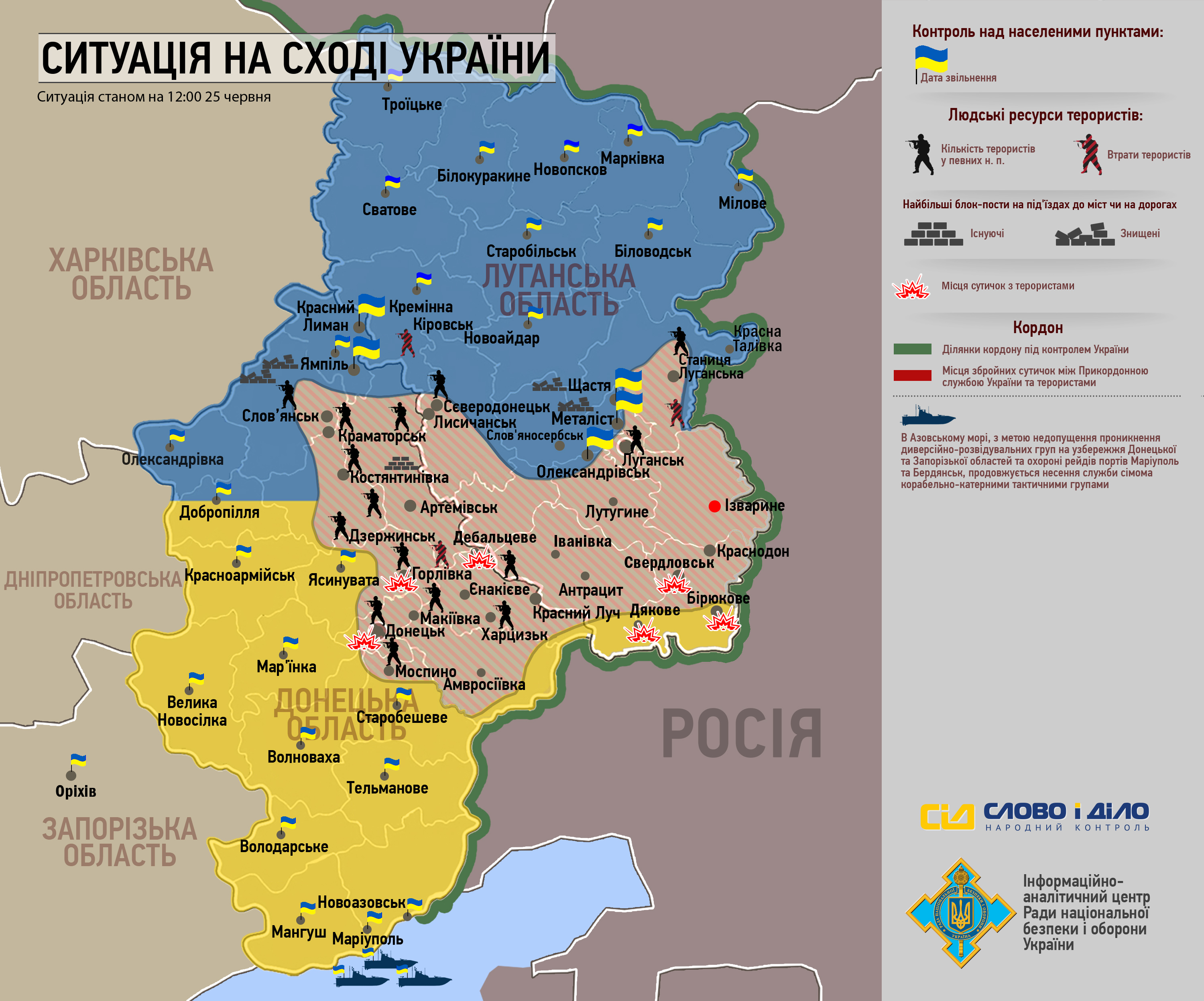
Hi, you made very good work in this map of Syria: https://commons.wikimedia.org/wiki/File:Syrian_civil_war.png Perhaps you can make similar map for conflict in Ukraine? I am aware that you already made this one: http://commons.wikimedia.org/wiki/File:Federal_State_of_New_Russia.svg However, I think that there should be also an different version of that map, the one which would show control of main towns and settlements like the map of Syria. Territories controlled by forces of New Russia and forces of Ukraine should be also depicted with different colors, like in the map of Syria. PANONIAN (talk) 14:48, 17 June 2014 (UTC)
- I'll tell you my secret! I basically screenshot w:Template:Syrian Civil War detailed map and put into paint.NET and edited it from there. It's somewhat easy, but it's lengthy. If someone were to make a template like that (same with Iraq) for East Ukraine, I'll do it, otherwise it will come out terribly (I've tried before, just look at File:Territorial control of the ISIS.svg before June, and you'll see how sloppy it is in Iraq. I need map labeled, and that can enable me to make a map for Ukraine. File:Federal_State_of_New_Russia.svg was only possible because I combined the files of Donetsk and Luhansk. But yeah, if a template were to be made, that would enable me to make the map. Thanks for asking, and I'll see what I can do.—SPESH531Other 16:54, 17 June 2014 (UTC)
- OK, but who can make a template for New Russia? Do you know some user who knows how to make this template? As I see, w:Template:Iraq_war_detailed_map was made by w:User:Malik Danno. Maybe we should ask him to make one for New Russia? PANONIAN (talk) 18:26, 17 June 2014 (UTC)
- That's twice you edit conflicted me! And BTW, I shortened the links. Anyway, I know w:User:Lothar von Richthofen made the w:Template:Syrian Civil War detailed map. I guess ask either one.—SPESH531Other 18:33, 17 June 2014 (UTC)
- OK, but who can make a template for New Russia? Do you know some user who knows how to make this template? As I see, w:Template:Iraq_war_detailed_map was made by w:User:Malik Danno. Maybe we should ask him to make one for New Russia? PANONIAN (talk) 18:26, 17 June 2014 (UTC)
syria_location_map2[edit]
i advise you that you add the rivers and the lakes that were added to the syria_location_map3 to the syria_location_map 2 also,thank you Alhanuty (talk) 01:27, 23 June 2014 (UTC)
File:2014_world_cup.png[edit]
Thank you for updating the map but Uruguay got the wrong color in in the latest update.--ArildV (talk) 23:03, 26 June 2014 (UTC)
Some useful sources for maps update[edit]
Hi, I recently found on the net few maps which showing frontline in Iraq and Ukraine.
Here are maps of Iraq:
- http://www.stratfor.com/sites/default/files/main/images/iraq_syria-isis-activity-06-18-2014.jpg
- http://cdn.static-economist.com/sites/default/files/imagecache/original-size/images/print-edition/20140614_MAM914.png
- http://cdn.static-economist.com/sites/default/files/imagecache/original-size/images/print-edition/20140628_MAM927.png
And these are for Ukraine:
- http://coffeespoons.me/wp-content/uploads/2014/06/map.jpg
- http://www.rnbo.gov.ua/files/2014/map2506.jpg
If you wish, you can use these sources to update borders in your mAPS:
- https://commons.wikimedia.org/wiki/File:Syria_and_Iraq_2014-onward_War_map.png
- https://commons.wikimedia.org/wiki/File:Federal_State_of_New_Russia.svg
PANONIAN (talk) 13:00, 28 June 2014 (UTC)
File:Territorial control of the ISIS.svg[edit]
ISIS now claims control over all the world, so I don't think it's relevant to show which areas do they claim, in orange. (Sorry, I don't know how to edit svg files)Mondolkiri1 (talk) 15:06, 3 July 2014 (UTC)
Somali Civil War Map[edit]
I noticed you've been making updates to the Somali Civil War map. There was a major territorial change last month that is not reflected on the current map. Most of the areas held by Khaatumo State have since been overrun and are held by Somaliland forces. The northern areas around Taleh (or Talex) are particularly in firm Somaliland control. See here [[10]]. As for the area around Widh-Widh, i have unfortunately been unable to find any source stating who controls it.XavierGreen (talk) 18:27, 5 July 2014 (UTC)
Hi Spesh531. Please don't ever again upload a new version before a game is over. --Leyo 22:41, 8 July 2014 (UTC)
Iraq and Syria maps[edit]
Thanks for the barnstar and thanks for starting all these maps, I find them very clear, useful and interesting! ![]() --Joan301009 (talk) 20:15, 9 July 2014 (UTC)
--Joan301009 (talk) 20:15, 9 July 2014 (UTC)

The Graphic Designer's Barnstar I have just seen that you have created this. And you have worked a lot with all these maps. So, I think that if I have a Barnstar, you should have it too. Thanks for all this work! --Joan301009 (talk) 18:22, 7 September 2014 (UTC)

.svg)
.svg)
.svg)
.svg)
.svg)
.png)
.png)
.png)
.svg)
.svg)
![[4]](https://commons.wikimedia.org/wiki/File_talk:Libyan_Uprising-es.svg#Al_Yauf_no_es_Kufra)
.svg&action=edit&redlink=1)
.svg)
.svg)
.svg)
.svg)
.svg)
.svg)
.svg)
.svg)
.svg)
.svg)
.svg)
.svg)
.svg)
.svg)
.svg)
.svg)
.svg)
.png&action=edit&redlink=1)
.png)
.png)
.png&action=edit&redlink=1)
.png)
.png)
.png&action=edit&redlink=1)
.png)
.png)
Borders of Kurdistan[edit]
Hi, what you think about my comment here: https://commons.wikimedia.org/wiki/File_talk:Iraqi_Kurdistan_in_Iraq_(de-facto_and_disputed_hatched).svg
.svg)
I just recently found these maps with borders of Kurdistan from official Kurdish source. So, perhaps you can change borders in your map accordingly? Which source you used for official borders of Kurdistan in your map? PANONIAN (talk) 09:49, 10 August 2014 (UTC)
I beg you, please update Globalization Index[edit]
Please do update Globalization Index to its 2014 version (http://globalization.kof.ethz.ch/)--86.3.42.147 00:52, 11 September 2014 (UTC)
- Look, at this point, I'll wait for 2015.—SPESH531Other 21:29, 11 October 2014 (UTC)
Battle of Hasakah[edit]
You can update this map Battle of Hasakah because Syrian army recaptured Ghuweiran neighborhood in city Hasakah.SOHRDocumens.Sy--Hanibal911 (talk) 10:43, 17 September 2014 (UTC)
I noticed you are focusing on keeping this map up to date. I was wondering if you could come up with an animated version much like File:Korean war 1950-1953.gif. Please also include the "ambition/claim" of ISIS to show its consistency or change. It may be also worthwhile to denote major events such as the capture of Tikrit, Mosul, Mosul dam etc with some sort of symbolism. -- とある白い猫 ちぃ? 06:57, 23 September 2014 (UTC)
The Golan[edit]
Coming back to the issue of Golan Heights, i would like to point out that there doesn't seem to be a new consensus for some new opinion on the Golan Heights coloring, other than making the Golan striped-colored, as agreed regarding Syrian maps in 2013, and accordingly Israeli maps in 2014. While in main ISIS control map the Golan is shown accordingly striped, there is no consistency on Syrian Civil War map (Israeli-controlled Golan shown as white since August 24), and on Syrian Civil War + Iraqi Insurgency map (Israeli-controlled Golan shown as white since you changed striped to white on September 23). Can we be consistent on the striped coloring of Israeli-controlled Golan, at least until another consensus is reached on Syrian and Israeli maps or alternatively on the Syrian Civil War article? Thanks and regards.Greyshark09 (talk) 22:08, 27 September 2014 (UTC)
Bad change[edit]
The agreement here: https://en.wikipedia.org/wiki/Talk:Syrian_Kurdistan#Military_map_issues was that the Golan was to be white, and the text in articles says that Israel is occupying the white part, why did you ad another color to it? --Supreme Deliciousness (talk) 01:42, 7 October 2014 (UTC)
- There wasn't exactly an agreement, three users (one including you) said they supported the white Golan Heights. Just three people is not a deciding factor.—SPESH531Other 02:53, 7 October 2014 (UTC)
- No it was 4 people, and no valid arguments against. 4-0 is clear consensus.--Supreme Deliciousness (talk) 23:54, 7 October 2014 (UTC)
- Four people is a small agreement, not a consensus.—SPESH531Other 21:28, 11 October 2014 (UTC)
- Where was the agreement that said it should be brown? And in the same color as Aleppo ? --Supreme Deliciousness (talk) 23:55, 30 October 2014 (UTC)
- Four people is a small agreement, not a consensus.—SPESH531Other 21:28, 11 October 2014 (UTC)
- No it was 4 people, and no valid arguments against. 4-0 is clear consensus.--Supreme Deliciousness (talk) 23:54, 7 October 2014 (UTC)
Syria-Iraq[edit]
Hi, could you make a topographic version of that location map? Would be great.--عبد المؤمن (talk) 02:03, 14 October 2014 (UTC)
Syrian civil war[edit]
You can correct this map Syrian civil war Because ISIS not control the area to south of the city Palmyra. This confirmed pro opposition map.here--Hanibal911 (talk) 09:05, 20 October 2014 (UTC)
- This map shows that it does (I have already made the changes back however).—SPESH531Other 23:25, 20 October 2014 (UTC)
Hi. I wonder what are your sources for these territory claims. I didn't hear any report that said IS advanced in north and south of Palmyra and - by your Map - cut the Assad's Forces territory and supply roots. You have to notice that this part of Syria is a desert. Instead the reports says that a month ago Assad's forces have recaptured Tabqa. (Ref: Timeline of the Syrian Civil War (August 2014–present)). Also there's no report on vast changes on south front in Daraa that in your Map showed. P. Pajouhesh (talk) 14:14, 20 October 2014 (UTC)
- I simply screenshot the templates from wikipedia, and make fronts based on that information.—SPESH531Other 23:25, 20 October 2014 (UTC)
- Also, a (from what I can tell, neutral) source for the splitting of Assad's supply roots can be seen in, this map.—SPESH531Other 23:30, 20 October 2014 (UTC)
- I think your source supports my claim about north and south of Palmyra. The Map says that only on south of Tabqa There are "ISIS Opereational Presence". not "Control Areas" in centeral Syrias desert and towns. These are very different. Also In south of Palmyra it is clearly denies any territory under IS rule.P. Pajouhesh (talk) 09:35, 21 October 2014 (UTC)
Hannibal,the map clearly shows that Al-Halbah is under IS control,so south palmyra is to stay under IS control.Alhanuty (talk) 03:33, 21 October 2014 (UTC)
- Rebels advance towards of Nassib border crossing so that the cities Umm al Mayaden and Nassib maybe captured by rebels or contested but they cant be marked under army control. SOHR reported that Islamic battalions’ fighters took control over al Jeser checkpoint near the town of Umm al Mayaden. And helicopters dropped barrel bombs onto the towns of al Teba, Nassib and Umm al Mayaden in the eastern countryside. Also regime forces shelled areas in the town of Nasib with no information about casualties.SOHR Hanibal911 (talk) 10:42, 21 October 2014 (UTC)
EF English Proficiency Index - update[edit]
Please, could you update it: http://www.ef.co.uk/epi/ ? --86.3.200.81 19:05, 14 November 2014 (UTC)
Israel as an irrelevant topic to ISIL map[edit]
Hi Spesh, Is it possible to produce a version of File:Syria and Iraq 2014-onward War map.png that presents the Golan Heights in a less prominent colour. It used to be white. I think that it is possible that the same type of influences are working on the map to highlight an involvement of Israel that is not a reality in regard to the Syrian conflict. i really appreciate your edit in June when you made that region just as grey. The country is not on the list of countries that are in military conflict with ISIL and they are not on the list of nations and umbrella groups that have designated them as terrorist. Israel is a non-participant in the ISIL conflict and, as far as I can see, its inclusion is unwarranted. If you can do anything about this that would be great. No Reliable source that I have seen presents any part of Israel on its maps. If you can reverse the colour change back to grey or white that would be appreciated. Template:TY Gregkaye (talk) 13:25, 17 December 2014 (UTC)
- When I had it gray, their were two other pictures that we're created to try and represent Israel in some fashion. One had it blue, the other was white. I changed gray to striped gray and olive[ish] to be a temporary solution. I'm in favor of the gray Golan Heights, but people start replacing the standard image with a [Filename]2 or 3. Nobody seems to be able to make an agreement overall. The only agreements I have seen are between 3 or 4 users with the same thinking, on both sides of the issue. Until a consensus is agreed on, I'll simply leave it striped, because I don't want to cause another dispute.—SPESH531Other 16:02, 17 December 2014 (UTC)
- Nice work with the red map with the removal of the pink. I think that this makes a lot more sense. :) GregKaye (talk) 21:14, 2 January 2015 (UTC)
- Quick question, what does the white represent? thanks. GregKaye (talk) 01:01, 6 January 2015 (UTC)
- Claims that ISIL has (no control)—SPESH531Other 02:35, 6 January 2015 (UTC)
- It seems the striped version works as a reasonable compromise between pro-Arab and pro-Israeli editors. I was the one to propose it to bridge the parties and it seems to be fairly acceptable for now. Certainly at some point all maps of the region would change.Greyshark09 (talk) 18:22, 17 May 2016 (UTC)
- Quick question, what does the white represent? thanks. GregKaye (talk) 01:01, 6 January 2015 (UTC)
- Nice work with the red map with the removal of the pink. I think that this makes a lot more sense. :) GregKaye (talk) 21:14, 2 January 2015 (UTC)
Islamic State of Iraq and the Levant[edit]
Please update File:Territorial control of the ISIS.svg and File:Iraqi Kurdistan in Iraq (de-facto and disputed hatched).svg. --Leftcry (talk) 05:50, 31 December 2014 (UTC)
.svg)
Countries belonging to UNASUR / UNASUL[edit]
Could I ask you, please, if you could fill the countries in UNASUR / UNASUL (South America) with a light green colour indicating the countries belonging to this bloc? (Like in the case cases of ASEAN, EU and African Union). I've been asked to do so, but these files have not been very easy for me, namely the one concerning to Brazil. Thanks for your attention.Mondolkiri1 (Mondolkiri1) 04:20, 4 January 2015 (UTC)
- Yes, I will attempt to make the changes.—SPESH531Other 20:16, 4 January 2015 (UTC)
- @Mondolkiri1: I actually have a better idea. The maps used for the AU and EU are not orthographic (EU I actually cannot tell that well), so instead of updating the orthographic maps, I will use File:South America laea location map.svg as the basis map, with the name of the file as "File:UNSAUR-Country Name.svg" using the same color scheme as File:EU-Italy.svg (just an example of an EU member). There will also be an insert map. Since Antarctica is in the file (outside the image boundaries) I can expand the Chile and Argentina maps to show claims in Antarctica, if need be, but I want your opinion.—SPESH531Other 21:18, 4 January 2015 (UTC)
- Yes, I think your idea is a good one. I'd like only to remind you that this bloc is UNASUR in Spanish, and UNASUL in Portuguese (So, in the case of Brazil that's the most adequate subtitle to be used, I guess. Concerning to the claims of Argentina and Chile in Antarctica, I think they should be displayed in a 3rd colour. Thanks a lot for your attention.Mondolkiri1talk 21:37, 4 January 2015 (UTC)
- Well, if you wish I change the maps in the other wikipedias, namely the ones in Latin languages, since until now I've been blocked from the English Wikipedia on the grounds of "excessive argumentation on some talk pages or page". Concerning to English WP, I'd appreciate your cooperation, though, since I'm not able, right now, to edit the English WP articles. Thanks for your attention. Mondolkiri1talk 23:24, 5 January 2015 (UTC)
- Hi Spesh! Keep up us updated on your maps for South America! Thanks!-Viladive (talk) 17:08, 6 January 2015 (UTC)
- @Mondolkiri1 and Viladive: Here are the two images that I have uploaded as examples. The layout of the Brazilian map will be the same except for Chile and Argentina, which has the format of the Argentine map.—SPESH531Other 04:51, 7 January 2015 (UTC)
- This is flawless! Thanks for your work on the maps! People like you are the ones that make wikipedia what it truly should be: a great source of valuable information. Thank you for your extraordinary commitment on wikipedia commons and accurate cartography. We'll be awaiting your uploads. Cheers!-Viladive (talk) 17:44, 7 January 2015 (UTC)
- The user Chronus isn't satisfied yet, because Brazil is a very big country, and the other countries with similar dimensions are displayed in orthographic projections. Is there a way to transform this Brazilian map into an orthographic projection? Thanks for your attention again, and sorry for bothering you so much about this issue.Mondolkiri1talk 18:58, 7 January 2015 (UTC)
- I am basing the UNASUL/UNASUR/USAN/UZAN maps on nations like Algeria, Italy, Germany, Sudan, etc. on English Wikipedia, which does not show orthopedic projections, it shows mainly the continent. Maybe I can make two different images, but the style that I have created follows member states of EU and AU on English Wikipedia.—SPESH531Other 21:00, 7 January 2015 (UTC)
- Well, both Brazil and Argentina are larger than any of those countries. And if Argentina is displayed in a way, so should be Chile, I guess. Well, those maps can be applied in the English WP (which I can't edit now, since I'm now blocked for excessive argumentation). In the Portuguese and Spanish WP they might eventually cause more controversy, though. I'll also invite Viladive to comment on this. Mondolkiri1 talk 21:08, 8 January 2015 (UTC)
- Hi Spesh, regarding the question you asked on my talk page, yes the Argentina map is Ok. The Brazil map is ok aswell. I will start using your versions on the english wikipedia (at least) very soon.-Viladive (talk) 15:46, 17 January 2015 (UTC)
- I am basing the UNASUL/UNASUR/USAN/UZAN maps on nations like Algeria, Italy, Germany, Sudan, etc. on English Wikipedia, which does not show orthopedic projections, it shows mainly the continent. Maybe I can make two different images, but the style that I have created follows member states of EU and AU on English Wikipedia.—SPESH531Other 21:00, 7 January 2015 (UTC)
- The user Chronus isn't satisfied yet, because Brazil is a very big country, and the other countries with similar dimensions are displayed in orthographic projections. Is there a way to transform this Brazilian map into an orthographic projection? Thanks for your attention again, and sorry for bothering you so much about this issue.Mondolkiri1talk 18:58, 7 January 2015 (UTC)
- This is flawless! Thanks for your work on the maps! People like you are the ones that make wikipedia what it truly should be: a great source of valuable information. Thank you for your extraordinary commitment on wikipedia commons and accurate cartography. We'll be awaiting your uploads. Cheers!-Viladive (talk) 17:44, 7 January 2015 (UTC)
- @Mondolkiri1 and Viladive: Here are the two images that I have uploaded as examples. The layout of the Brazilian map will be the same except for Chile and Argentina, which has the format of the Argentine map.—SPESH531Other 04:51, 7 January 2015 (UTC)
- Yes, I think your idea is a good one. I'd like only to remind you that this bloc is UNASUR in Spanish, and UNASUL in Portuguese (So, in the case of Brazil that's the most adequate subtitle to be used, I guess. Concerning to the claims of Argentina and Chile in Antarctica, I think they should be displayed in a 3rd colour. Thanks a lot for your attention.Mondolkiri1talk 21:37, 4 January 2015 (UTC)
Concluded
Thank you Spesh for your help. I have updated all South American countries with your maps on the english wikipedia. @Mondolkiri1: you can update the Spanish and Portuguese wikipedia versions with Spesh's maps if you wish-Viladive (talk) 23:05, 22 January 2015 (UTC)
- The made maps of the unasur are not good. Where is the consensus of the community?--Roboting (talk) 20:40, 25 January 2015 (UTC)
- Hello! What about the consensus of the community? Supposedly, there should be one before changing all the maps of South American countries, not only in English but also in Spanish and Portuguese versions of Wikipedia. Thanks for reading this message. Best wishes!--Alpinu (talk) 21:22, 25 January 2015 (UTC)
- @Viladive, Roboting, and Alpinu: Please take this elsewhere, I have only created the image. I do not want to be part of this discussion. (That is unless I decide otherwise}—SPESH531Other 05:01, 26 January 2015 (UTC)
- I ask you to let the articles of the countries of wikipedia as they were. It is an arbitrary edition they have done.--Roboting (talk) 05:18, 26 January 2015 (UTC)
- Talk to Viladive about it, I was asked to make maps for UNASUR-Country, I thought "sure, why not" and created them. I was not the one that had implemented the maps.—SPESH531Other 05:22, 26 January 2015 (UTC)
- Hello! What about the consensus of the community? Supposedly, there should be one before changing all the maps of South American countries, not only in English but also in Spanish and Portuguese versions of Wikipedia. Thanks for reading this message. Best wishes!--Alpinu (talk) 21:22, 25 January 2015 (UTC)
question: an extension of the blank world map[edit]
He Spesh, if I look at your edits, you have been involved in technical issues regarding the blank svg worldmaps. I use them regularly, mainly for identifiying parties and signatories to treaties. However, several "federal entities" have different treaty membership for their individual units. This goes for the Canada and UK and it would be great is they could thus be coloured separately using their w:ISO 3166 -2 code. In addition, the US and Australia have much legislation on state-level, and thus (e.g. age for a driver's licence, maximum speeds) world maps are used there which have a second level subdivision (state/province), but those images are basically inkscape versions... I have made a request for extending the blank world map to the first level subdivisions of those 4 countries Graphic Lab/Map workshop#Subnational entities on world map? at the map workshop, but that hasn't gained any traction. Would you know who would be capable and willing to make such a map (you?)? Would be great to have this available! L.tak (talk) 12:45, 14 January 2015 (UTC)
- My work with SVG is strictly through inkscape. I do not know how to edit SVG through code, only through inkscape I can attempt to create an SVG map that has sub-boundaries for those four countries. I can also start adding for other countries. However, the map should be a work-in-progress map, constantly updated do other users can edit, and in the final version, a user can edit the image to take out the inkscape data that effects the image. Like I said, it may take a long time. —SPESH531Other 15:25, 14 January 2015 (UTC)
- Well, the point is not that there are no subnational border maps (see for example File:World98.svg), but the ease of editing them (by stating simply in the top of the svg file ".uk-sc" to colour scotland for example). However, if you could (as a test) add a shape (not just the border) for Scotland in the blank worldmap that is suitable for this type of editing, then I can see if I can adjust the generated File:BlankMap-World6.svg-based file and see if I can code Scotland in... I'd be interested to see if that would work! L.tak (talk) 16:37, 18 January 2015 (UTC)
Blank Map of the World[edit]
Hello, I just have a question about File:BlankMap-World.png, why does Antarctica look the way it does? --Leftcry (talk) 03:46, 9 February 2015 (UTC)
File:Territorial control of the ISIS.svg[edit]
Hi Spesh531,
Thanks again for all the work on the images. I was wondering about the territorial control image and whether a grey presentation might rightly be added to Algeria, Kuwait, Saudi Arabia, and Yemen. I am not sure of any extent to which ISIL have any actual territorial control in these countries or whether people there are doing anything beyond such activities as refusing to pay tax and similar. Is the reason that there were ISIL associated raids or something. If so I don't think that reason may remain to continue differentiation on the territorial control map. What do you think? I know that you had also helpfully joined the argument to remove the Golan Heights from the main map and wondered whether similar removal could be affected here.
I was also wondering about outlines of the separate map sections and of within country divisions and scales. I now presume that the Libyan map section is at the same scale as the Iraq/Syria map section but was uncertain until checking and was wondering about possible ways that scale might be indicated. As a start, could the outline around the top right section be thickened and the outline around the bottom right section be thinned. This thought is on the basis that, if it is just the top right section that is at a different scale then this is the bit that should be set apart. Would a scale of perhaps 100 km be relevant on the two sections as here. I had found the province boundaries confusing and, in connection with the Libyan map, had questioned whether the province boundaries might have been country boundaries. Putting Algeria in grey may alleviate any possible confusion but perhaps a removal or further thinning of province boundaries might help. It think that seeing thick boundaries on the Iraq/Syria map and the thin boundaries on the Libyan map got me thinking that the latter was at a smaller scale.
Can the borders between Iraq, Syria and Saudi Arabia be represented with the normal thickness of line for national boundaries? I don't understand other usage here and think that the simple presentation would make most sense.
Thanks for all.
GregKaye (talk) 11:00, 13 February 2015 (UTC)
Mali[edit]
Hi. Since you are interested in conflict maps, I recently found info about renewed conflict in Mali or its region of Azawad. Check these sources:
- http://www.dailyplebiscite.com/en/2015/02/17/true-world-map-not-look-usually-portrayed/
- https://twitter.com/arabthomness/status/470609506620440576
I think that Wikimedia should have a map of Mali conflict like there are maps of conflicts in Iraq, Syria, Libya, Yemen etc. What you think? Should one be made? Also, can you make such map or you know someone else who might do it? I mean, I also can make maps, but not of that kind. PANONIAN (talk) 20:58, 18 February 2015 (UTC)
"Islamic State" map[edit]
Hello,
Could you please update the map of the controlled and revendicated areas of the so-called "Islamic State" (File:Territorial control of the ISIS.svg)? Especially, it is necessary to add now the Boko-Haram-controlled regions (North-East of Nigeria) since Boko Haram proclaimed its allegiance to the IS (here is a map of Boko-Haram-controlled territories, File:Islamist insurgency in Nigeria.svg, I don't know if it is really updated but it can give you a first guess for the update of the IS map). To be complete, here is the list of the country where the IS (including the groups it recognizes as vassal) act: Iraq, Syria, Lebanon, Libya, Nigeria, Cameroon, Niger, Chad, Egypt, Algeria, Yemen, Saudi Arabia and Philippines.
Thank you in advance.
Best regards,
SenseiAC (talk) 16:11, 11 March 2015 (UTC)
- Hi, personally I would only include those regions that the Islamic State has formally announced Wilayat or Provinces. Which so far consists of Iraq, Syria, Sinai, Libya, Algeria, Yemen, Saudi Arabia and 'Khorasan'. It is likely they will announce a province in Nigeria in the coming weeks. Gazkthul (talk) 21:37, 12 March 2015 (UTC)
- Khorasan, ie eastern Iran? really? If you have a source for the claimed regions, it would be great to color them in a specific color (intermediate color between the "dark red" of the controlled territory and the yellow of the full territories of the countries where a group is recognized as having proclaimed allegiance to the IS). Also, if you have the list of these 'provinces' (and the corresponding references), it'd be great if you could provide me it in order to complete the French article about the IS. At least, for the moment, I see two corrections for the map: (1) you draw an 'point-point' (ie international) border within Libya, while Libya is only one country (even if a civil war is ongoing); and (2) part of the Irak-Saudi Arabia border is not 'point-point' but 'large continue line' (as is the external border of the IS and the international border outside the countries with a group recognized as a part of the IS.
- Hello, Boko Haram's allegiance to the Islamic State has been officially recognized by the IS on Thursday 12 March 2015, so could you update the map? And correct the borders that need to be corrected? Thank you in advance. Best regards. SenseiAC (talk) 15:35, 21 March 2015 (UTC)
- Khorasan, ie eastern Iran? really? If you have a source for the claimed regions, it would be great to color them in a specific color (intermediate color between the "dark red" of the controlled territory and the yellow of the full territories of the countries where a group is recognized as having proclaimed allegiance to the IS). Also, if you have the list of these 'provinces' (and the corresponding references), it'd be great if you could provide me it in order to complete the French article about the IS. At least, for the moment, I see two corrections for the map: (1) you draw an 'point-point' (ie international) border within Libya, while Libya is only one country (even if a civil war is ongoing); and (2) part of the Irak-Saudi Arabia border is not 'point-point' but 'large continue line' (as is the external border of the IS and the international border outside the countries with a group recognized as a part of the IS.
Battle of Hasakah[edit]
You can update map Battle of Hasakah! Here new source:here and village Al-Dhiyabah also under control by Syrian troops.here --Hanibal911 (talk) 17:07, 11 May 2015 (UTC)
|
|
File:2011 Battle of Sirte.svg has been listed at Commons:Deletion requests so that the community can discuss whether it should be kept or not. We would appreciate it if you could go to voice your opinion about this at its entry.
If you created this file, please note that the fact that it has been proposed for deletion does not necessarily mean that we do not value your kind contribution. It simply means that one person believes that there is some specific problem with it, such as a copyright issue. Please see Commons:But it's my own work! for a guide on how to address these issues. |
Archer90 (talk) 12:27, 27 June 2015 (UTC)
|
|
File:Flag of New Caledonia.svg has been listed at Commons:Deletion requests so that the community can discuss whether it should be kept or not. We would appreciate it if you could go to voice your opinion about this at its entry.
If you created this file, please note that the fact that it has been proposed for deletion does not necessarily mean that we do not value your kind contribution. It simply means that one person believes that there is some specific problem with it, such as a copyright issue. Please see Commons:But it's my own work! for a guide on how to address these issues. |
Tharkun (talk) 15:20, 1 August 2015 (UTC)
|
|
File:Recognition of Crimean Referendum.svg has been listed at Commons:Deletion requests so that the community can discuss whether it should be kept or not. We would appreciate it if you could go to voice your opinion about this at its entry.
If you created this file, please note that the fact that it has been proposed for deletion does not necessarily mean that we do not value your kind contribution. It simply means that one person believes that there is some specific problem with it, such as a copyright issue. Please see Commons:But it's my own work! for a guide on how to address these issues. |
JuTa 12:10, 14 November 2015 (UTC)
|
|
File:A map of the Arab World with flags.svg has been listed at Commons:Deletion requests so that the community can discuss whether it should be kept or not. We would appreciate it if you could go to voice your opinion about this at its entry.
If you created this file, please note that the fact that it has been proposed for deletion does not necessarily mean that we do not value your kind contribution. It simply means that one person believes that there is some specific problem with it, such as a copyright issue. Please see Commons:But it's my own work! for a guide on how to address these issues. |
Neymar1384 (talk) 20:16, 20 November 2015 (UTC)
Hello, you can make a Turkey location map for Turkish Insurgency ? Like Syria location map. But this does not seem to map rivers in Turkey. Can you add to this rivers map? for example, the Tigris and Euphrates rivers. And rivers in neighboring countries. For example, Iraq, Syria, Iran, Armenia, Russia, Bulgaria and Greece. The background color of the provinces on the map should be a little darker, a little white color .. .. And the borders of the provinces should be slightly thicker than black. Bruskom talk to me 14:24, 24 December 2015 (UTC)
Animation icons[edit]
Hi, can you spare some of your time to create a green-blue and a green-yellow animation? (like grey-blue ![]() ). The green color is required for the color of Turkey in the Mid-East map to differentiate it from Arab forces (lime); the green color is also required to show Hamas as opposed to the Fatah-led State of Palestine control in the West Bank (lime). Thanks in advance.Greyshark09 (talk) 18:25, 17 May 2016 (UTC)
). The green color is required for the color of Turkey in the Mid-East map to differentiate it from Arab forces (lime); the green color is also required to show Hamas as opposed to the Fatah-led State of Palestine control in the West Bank (lime). Thanks in advance.Greyshark09 (talk) 18:25, 17 May 2016 (UTC)
- Greyshark09 After I had already made the files on computer, I found out that the two files already exist.
 and
and  —SPESH531Other 03:37, 19 May 2016 (UTC)
 - Although I just saw the map now, are the green and lime supposed to be two different factions? That doesn't quite make sense.—SPESH531Other 03:39, 19 May 2016 (UTC)
- Ok, regardless of what is what, I uploaded the blue/green file.
 —SPESH531Other 03:47, 19 May 2016 (UTC)
- First of all - thanks for the darkgreen-blue animation. However, i also asked for darkgreen-yellow animation (not lime-blue or yellow-blue). Thanks if you have the time.Greyshark09 (talk) 18:24, 30 May 2016 (UTC)
- Sorry! I must've gotten mixed up, I believe I did this late at night ad was on little sleep! Anyway here is the yellow-green animation
 —SPESH531Other 17:41, 31 May 2016 (UTC)
- Great! Thanks.Greyshark09 (talk) 21:36, 2 June 2016 (UTC)
- Sorry! I must've gotten mixed up, I believe I did this late at night ad was on little sleep! Anyway here is the yellow-green animation
- First of all - thanks for the darkgreen-blue animation. However, i also asked for darkgreen-yellow animation (not lime-blue or yellow-blue). Thanks if you have the time.Greyshark09 (talk) 18:24, 30 May 2016 (UTC)
- Ok, regardless of what is what, I uploaded the blue/green file.
Hi, Spesh. I noticed you introduced tiny details in this map. This is undoubtfully the most detailed map here. But some details are not there and it's still not showing the details of all maps here in Wikipedia. I can't edit vector graphics so as the picture can look the same way the other editors edit it. Could you help me with adding something, not now, maybe in a long-term period? If you are willing to do so, please check the all the "Demogrpahics of" articles of European countries, I added there respective maps that can provide more details on linguistic composition than currently this map provides. Roma language needs to be added by the way if we take a look at the detailed maps of Slovakia, Bulgaria, Romania and probably Macedonia. Best,--Nonemansland (talk) 00:26, 12 February 2017 (UTC)
Battle of Raqqa2.svg[edit]
Why do you flatten this pictures ? The real height is 705 pixels, no 581. Please restore the correct size. A.BourgeoisP (talk) 19:54, 9 June 2017 (UTC)
- I restored. Please retain this framework in the future. A.BourgeoisP (talk) 20:01, 9 June 2017 (UTC)
- It fits well with the w:Template:Syrian,_Iraqi,_and_Lebanese_insurgencies_detailed_map and w:Template:Syrian_Civil_War_detailed_map when flattened.—SPESH531Other 20:06, 9 June 2017 (UTC)
Hi Spesh. I don’t think that creating File:Battle of Raqqa (2017) for Templates.svg is a good idea. In theory it seems reasonable. However, from my experience, having multiple files for the same battle is problematic because users who edit pictures are very few and they will not usually edit all the files at the same time.
_for_Templates.svg)
For example, you created File:Battle of Raqqa (2017) for Templates.svg, but then user:Thumboy, on 14:27, 25 June 2017 (UTC) added to File:Battle of Raqqa2.svg labels, which is quite useful. However, the problem is that he (or someone else) didn’t add the labels to File:Battle of Raqqa (2017) for Templates.svg. I don’t expect user:Thumboy and user:Yug (and others) to update File:Battle of Raqqa (2017) for Templates.svg when they update File:Battle of Raqqa2.svg. Also, I don’t expect you to keep updating File:Battle of Raqqa (2017) for Templates.svg to keep it synchronized with File:Battle of Raqqa2.svg. The result is that there is a higher probability that the picture in our Syria Civil War map will be outdated.
To further illustrate my point, I will use the example of File:Battle of Raqqa (2017).svg (which I don’t care about). It is yet another file of the battle of raqqa and notice how it was not updated since 14 May 2017! From my experience, we should always have only one file per battle. Therefore I ask you to:
.svg)
- Abandon File:Battle of Raqqa (2017) for Templates.svg
- Adjust File:Battle of Raqqa2.svg again to make it "Flattened" map
Thanks. Tradediatalk 16:29, 27 June 2017 (UTC)
- See also https://en.wikipedia.org/w/index.php?title=Talk:Cities_and_towns_during_the_Syrian_Civil_War&diff=792050963&oldid=791739026 Tradediatalk 01:17, 28 July 2017 (UTC)
World administrative levels[edit]
Hi, I'm looking for source file of one of Your map from there: https://upload.wikimedia.org/wikipedia/commons/e/ee/World_administrative_levels.png. I need this file for example in .mif or .shp type. Could You share it? — Preceding unsigned comment added by Earthdiv (talk • contribs) 09:19, 21 September 2017 (UTC)
|
|
File:Iraq location map2.svg has been listed at Commons:Deletion requests so that the community can discuss whether it should be kept or not. We would appreciate it if you could go to voice your opinion about this at its entry.
If you created this file, please note that the fact that it has been proposed for deletion does not necessarily mean that we do not value your kind contribution. It simply means that one person believes that there is some specific problem with it, such as a copyright issue. Please see Commons:But it's my own work! for a guide on how to address these issues. |
Guanaco (talk) 02:17, 12 November 2017 (UTC)
|
|
File:Flag of the Cayman Islands.svg has been listed at Commons:Deletion requests so that the community can discuss whether it should be kept or not. We would appreciate it if you could go to voice your opinion about this at its entry.
If you created this file, please note that the fact that it has been proposed for deletion does not necessarily mean that we do not value your kind contribution. It simply means that one person believes that there is some specific problem with it, such as a copyright issue. Please see Commons:But it's my own work! for a guide on how to address these issues. |
Majora (talk) 22:17, 13 May 2018 (UTC)
|
|
File:World administrative levels.png has been listed at Commons:Deletion requests so that the community can discuss whether it should be kept or not. We would appreciate it if you could go to voice your opinion about this at its entry.
If you created this file, please note that the fact that it has been proposed for deletion does not necessarily mean that we do not value your kind contribution. It simply means that one person believes that there is some specific problem with it, such as a copyright issue. Please see Commons:But it's my own work! for a guide on how to address these issues. |
2601:183:101:58D0:1511:B779:5B78:8397 20:02, 6 June 2018 (UTC)
Map request[edit]
Hi. Could you make a Turkish version of this map? - Aybeg (talk) 11:51, 23 August 2019 (UTC)
Source of derivative work is not properly indicated: File:World map changes 06-8-6.png[edit]
| This file may be deleted. |
A file that you have uploaded to Wikimedia Commons, File:World map changes 06-8-6.png, is a derivative work, containing an "image within an image". Examples of such works would include a photograph of a sculpture, a scan of a magazine cover, or a map that has been altered from the original. In each of these cases, the rights of the creator of the original must be considered, as well as those of the creator of the derivative work.
While the description page states who made this derivative work, it currently doesn't specify who created the original work, so the overall copyright status is unclear. If you did not create the original work depicted in this image, you will need to specify the owner of the copyright. Please edit the file description and add the missing information, or the file may be deleted. If you created the original content yourself, enter this information as the source. If someone else created the content, the source should be the address to the web page where you found it, the name and ISBN of the book you scanned it from, or similar. You should also name the author, provide verifiable information to show that the content is in the public domain or has been published under a free license by its author, and add an appropriate template identifying the public domain or licensing status, if you have not already done so. Please add the required information for this and other files you have uploaded before adding more files. If you need assistance, please ask at the help desk. Thank you! |
Magog the Ogre (talk) (contribs) 02:15, 27 February 2021 (UTC)
|
|
File:Somaliland COA.gif has been listed at Commons:Deletion requests so that the community can discuss whether it should be kept or not. We would appreciate it if you could go to voice your opinion about this at its entry.
If you created this file, please note that the fact that it has been proposed for deletion does not necessarily mean that we do not value your kind contribution. It simply means that one person believes that there is some specific problem with it, such as a copyright issue. Please see Commons:But it's my own work! for a guide on how to address these issues. |
DownTownRich (talk) 01:58, 2 February 2022 (UTC)
File:CountriesRecognizingSNC.svg[edit]
Between 2013 and 2023, many countries withdrawn from recognition of SNC and normalized with Syria: Egypt, Tunisia, Saudi Arabia, Libya (GNA & LNA), Austria[1] Martimix (talk) 10:16, 26 July 2023 (UTC) Martimix (talk) 21:48, 31 July 2023 (UTC)
- ↑ (5 May 2022). "Jordan makes a U-turn to reintegrate Syria into the regional fold". Error: journal= not stated. TRT World.