Category:Bürgerhaus Römerstr 14 (Bregenz)
Jump to navigation
Jump to search
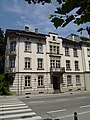
Deutsch: Bürgerhaus Römerstr 14 (Bregenz, Vorarlberg, Austria).
| Object location | | View all coordinates using: OpenStreetMap |
|---|
| This category shows the protected monument with the number 17680 in Austria. (Commons, de, Wikidata) |
building in Bregenz, Austria  | |||||
| Upload media | |||||
| Instance of |
| ||||
|---|---|---|---|---|---|
| Location | Bregenz, Bregenz District, Vorarlberg, Austria | ||||
| Street address |
| ||||
| Heritage designation | |||||
 | |||||
Media in category "Bürgerhaus Römerstr 14 (Bregenz)"
The following 3 files are in this category, out of 3 total.
-
 Bürgerhaus Römerstr 14 Bregenz.JPG 2,304 × 3,072; 1.71 MB
-
 Römerstraße 14, Bregenz 1.JPG 5,704 × 4,278; 12.29 MB
-
 Römerstraße 14, Bregenz 2.JPG 6,046 × 4,031; 13.42 MB

