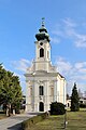
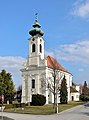
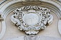
Category:Pfarrkirche hl. Leonhard, Ollersdorf
Jump to navigation
Jump to search
| Object location | | View all coordinates using: OpenStreetMap |
|---|
church building in Lower Austria, Austria .JPG)  | |||||
| Upload media | |||||
| Instance of | |||||
|---|---|---|---|---|---|
| Named after | |||||
| Location | Angern an der March, Gänserndorf District, Lower Austria, Austria | ||||
| Street address |
| ||||
| Architectural style | |||||
| Heritage designation | |||||
 | |||||
Media in category "Pfarrkirche hl. Leonhard, Ollersdorf"
The following 7 files are in this category, out of 7 total.
-
 Kath. Pfarrkirche hl. Leonhard in Ollersdorf.jpg 680 × 1,023; 338 KB
-
 Ollersdorf - Kirche (1).JPG 2,834 × 4,252; 9.97 MB
-
 Ollersdorf - Kirche (2).JPG 2,900 × 3,898; 9.95 MB
-
 Ollersdorf - Kirche (3).JPG 3,898 × 2,684; 8.72 MB
-
 Ollersdorf Pfarrkirche 1.jpg 1,280 × 1,920; 267 KB
-
 Ollersdorf Pfarrkirche 2.jpg 1,920 × 1,280; 350 KB
-
 Ollersdorf Pfarrkirche innen.jpg 1,920 × 1,280; 317 KB

.JPG)
.JPG)

