Brück
Jump to navigation
Jump to search
English: Brück is a town in the district Potsdam-Mittelmark, Brandenburg, Germany, approximately 60 km south-west from Berlin. Today belong to the town „Brück“ 7 further and incorporated villages. Town and villages are situated in the „Baruther Urstromtal“ (glacial valley) nearby the Belziger Landschaftswiesen.
Deutsch: Brück ist eine Stadt im Brandenburger Landkreis Potsdam-Mittelmark. Zu der Stadt zählen heute 7 weitere und eingemeindete Dörfer, die wie Brück selbst im Baruther Urstromtal und zum Teil am Rand der Belziger Landschaftswiesen liegen.
- See also: Belziger Landschaftswiesen
Brück
[edit]Coat of arms and maps
[edit]-
 Coat of arms / Stadtwappen
 -

-
 en: Pharus-map from 1903, Brück to Niemegk
 -
 de: Pharus-Plan von 1903, Brück bis Lehnin


Town Brück
[edit]-
 en: Aerial testing facility - Meßturm II; frame work tower built in 1963
 -
 de: Antennenmessplatz - Meßturm III; Holzturm, errichtet 1963.
 -
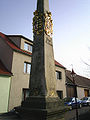
 en: Post-mile-column, built in 1730
 -
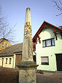 de: Kursächsische Postmeilensäule von 1730
 -
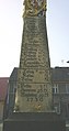
 dto.
dto. -
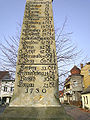
 dto.
dto. -
 dto.
dto.


Incorporated villages
[edit]Baitz
[edit]- See: Baitz (Brück)
Gömnigk
[edit]→ de
Mills, stream Plane and Planetal
[edit]-
 Neue Mühle (german for: New water wheel); Dorfstr. 55, ehemals Flurstück Nr. 20
 -
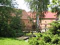
 Stream Plane at new watermill / Plane an der Neuen Wassermühle Gömnigk
 -
 dto.
dto. -
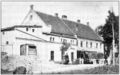 Alte Mühle, vor 1910 (german for: Old water wheel; before 1910), Dorfstraße 1
 -
 Dorfstr. 1 (Alte Mühle Nr.23)
 -
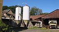 dto., Hof mit Silos
 -
 dto., Detail Hof
 -
 Dorfstr. 61, Wohnhaus von 1899 vor Alter Mühle
 -
 en:Field nearby Gömnigk
 -
 de:Feld bei Gömnigk
 -
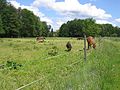
 en: Free range with pig breeding
 -
 de: Freilandhaltung mit ökologischer Schweinezucht


Church and other buildings
[edit]-
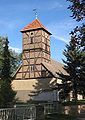
 en:Church, built probably in 14th century
 -
 de:Feldsteinkirche, wahrscheinlich aus dem 14. Jahrhundert
 -
 dto.
dto. -
 dto.
dto. -
 Village street / Dorfstraße
 -
 Dorfstr. 3, Gastwirtschaft Nr. 30a; Gasthaus seit 1877
 -
 Dorfstr. 9, ehemaliges Hüfnergut/Stammgut Nr. 11
 -
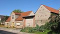 dto., mit Tor und Scheune
 -
 Dorfstr. 10, ehemaliges Kossätengut 10/Schmiede ...
 -
 ...dto. ...
 -
 ...dto. ...
 -
 ... heute Hof/Hofverkauf Ökobauer Schulz (Schweinezucht)
 -
 Dorfstr. 14, ehemaliges Kossätengut Nr. 7, zwischen 1910 und ...
 -
 ... (wahrscheinlich) 1920 Colonialwarenhandlung von Hermann Hahn
 -
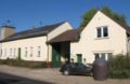
 Alte Schule, Dorfstr. 17, heute Gaststätte, Pension
 -
 Dorfstr. 25,24,23 ..., ehemalige Büdnergüter (Tagelöhnerhäuser) Nr. 32,33,35 ...
 -
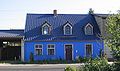 Dorfstr. 38, ehemaliges Büdnergut 41
 -
 Garten, Scheune Dorfstr. 42, ehemaliges Büdnergut Nr. 27
 -
 Scheune Dorfstr. 52, neben der Kirche, ehemaliges Stammgut Nr. 24


Building ground plans and sections
[edit]-
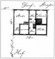
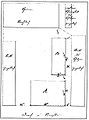
 en: Boundarys 1824 / de: Marken des Dorfes 1824
 -
 Neubau des Wohnhauses 1877, Dorfstr. 4 (ehemaliges Büdnergut Nr. 31)
 -
 Neubau der Scheune (barn) 1899, Dorfstr. 6 (ehemaliges Kossätengut Nr. 15)
 -
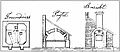
 Neubau Wohnhaus mit Schmiede (smithy) 1857, Dorfstr. 10 (ehemaliges Kossätengut Nr. 10 / 2006 Hof des Ökobauern Schulz)
 -
 Anbau eines massiven Backofens (oven) 1884 am Wohnhausanbau Dorfstr. 14 (ehemaliges Kossätengut Nr. 7)
 -
 Neuer Wohnhausanbau (annex) 1870 Dorfstr. 15 (ehemaliges Kossätengut Nr. 6)
 -
 Neubau des Wohnhauses 1882, Dorfstr. 54 (ehemaliges Stammgut/Hüfnergut Nr. 21)
 -
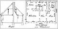
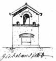 de: Neubau Stall mit Taubenhaus (hier Ausschnitt mit dem aufgesetzten Taubenhaus) 1869, Dorfstr. 57 (ehemaliges Büdnergut Nr. 18)
 -
 dto., en: new sty with dove-house, 1869
 -
 dto., Gesamtplan
 -
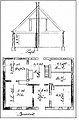
 Neuplanung (overall plan) des abgebrannten Hüfnerguts Nr. 24, 1856, heute Dorfstr. 51
 -
 Ziegeleibau (brickyard) 1855 mit Ziegelbrennofen, Haus- und Stall, Niemegker Str.2, durch den Hüfner Rettig
 -
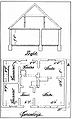
 Grundriss der Schule, 1903


Neuendorf
[edit]→ de
Village / Dorf
[edit]-
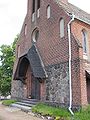
 en: Stonechurch, built probably in 15th century
 -
 de: Feldsteinkirche, wahrscheinlich 15. Jahrhundert
 -
 dto. Timber framing spire from / Fachwerkturm von ~1887
 -
 Barn / Scheune
 -
 Barn / Scheune
 -
 Dorfstraße
 -
 Bergstraße to plateau Zauche / zur Zauche
 -
 dto.
dto. -
 View to Zauche / Blick vom Urstromtal zur Zauche
_church.JPG)
_church.JPG)
_church.JPG)
_barn.JPG)
_barn.JPG)
_Dorfstrasse.JPG)
_Bergstrasse.JPG)
_Bergstrasse.JPG)
_Zauche.JPG)
Baruther Urstromtal (glacial valley) bei Neuendorf
[edit]-
 Way to the / Weg ins Urstromtal
 -
 en: see picture-text / de: Blick von Neuendorf zum Rest des ehemals ausgedehnten Bruchwaldes „Linther Oberbusch“ im Baruther Urstromtal
 -
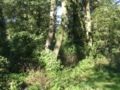 In the / Im Oberbusch
 -
 De-watering-canal / Meliorationsgraben im Urstromtal
 -
 „Neuer Graben“ (Nieplitz-Zufluss)
 -
 dto. nearby Schäpe / „Neuer Graben“ ca. 6 Kilometer östlich bei Schäpe (Beelitz)
 -
 Acre / Acker im Urstromtal, Hintergrund Zauche
 -
 Direction signs / Wegweiser
 -
 Old Street / Alter Fahrweg durch die Talung
 -
 Weir / Wehr
 -
 Bundesautobahn 9 durchs Urstromtal, Hintergrund Zauche
 -
 Old Street / Plattenweg
 -
 Shrub / Busch
1a_Urstromtal.JPG)
_Oberbusch.JPG)
_Oberbusch.JPG)
1b_Urstromtal.JPG)
2_Urstromtal.JPG)

3_Urstromtal.JPG)
4_Urstromtal.JPG)
5_Urstromtal.JPG)
6_Urstromtal.JPG)
7_Urstromtal.JPG)
8_Urstromtal.JPG)
9_Urstromtal.JPG)
Rottstock
[edit]-
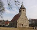
 Church, built probably in 15th century / Kirche, wahrscheinlich aus dem 15. Jahrhundert

Trebitz
[edit]→ de
-
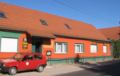
 Barn / Scheune
 -
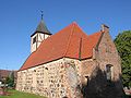
 Church / Dorfkirche
 -
 dto.
dto. -
 dto.
dto. -
 Railway de:Wetzlarer Bahn in Trebitz
 -
 Picnic area at the European bikeway Euroroute 1 (de:Europaradwanderweg R 1)
 -
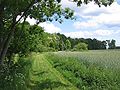
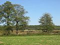
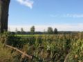
 Field in the Belziger Landschaftswiesen, in the North of Trebitz
 -
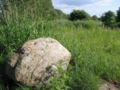 The same area with an erratic block / Findling
 -
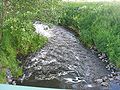 The same area with the stream Plane


