Category:Église Saint-Christophe de Romestaing
Jump to navigation
Jump to search
| Object location | | View all coordinates using: OpenStreetMap |
|---|
|
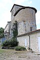
This building is inscrit au titre des monuments historiques de la France. It is indexed in the base Mérimée, a database of architectural heritage maintained by the French Ministry of Culture, under the reference PA00084217
|
church located in Lot-et-Garonne, in France  | |||||
| Upload media | |||||
| Instance of |
| ||||
|---|---|---|---|---|---|
| Named after | |||||
| Dedicated to | |||||
| Location | Romestaing, canton of Bouglon | ||||
| Architectural style | |||||
| Diocese | |||||
| Heritage designation |
| ||||
| Religion or worldview | |||||
 | |||||
Media in category "Église Saint-Christophe de Romestaing"
The following 21 files are in this category, out of 21 total.
-
 Romestaing - Eglise Saint-Christophe - 01.jpg 3,984 × 2,656; 2.11 MB
-
 Romestaing - Eglise Saint-Christophe - 02.jpg 2,656 × 3,984; 2.83 MB
-
 Romestaing - Eglise Saint-Christophe - 03.jpg 2,656 × 3,984; 2.64 MB
-
 Romestaing - Eglise Saint-Christophe - 04.jpg 2,656 × 3,984; 3.93 MB
-
 Romestaing - Eglise Saint-Christophe - 05.jpg 2,656 × 3,984; 2.09 MB
-
 Romestaing - Eglise Saint-Christophe - 06.jpg 2,656 × 3,984; 1.95 MB
-
 Romestaing - Eglise Saint-Christophe - 07.jpg 3,984 × 2,656; 1.79 MB
-
 Romestaing - Eglise Saint-Christophe - 08.jpg 3,984 × 2,656; 1.97 MB
-
 Romestaing - Eglise Saint-Christophe - 09.jpg 3,984 × 2,656; 2.05 MB
-
 Romestaing - Eglise Saint-Christophe - 10.jpg 3,984 × 2,656; 2.01 MB
-
 Romestaing - Eglise Saint-Christophe - 11.jpg 3,984 × 2,656; 2.05 MB
-
 Romestaing - Eglise Saint-Christophe - 12.jpg 3,984 × 2,656; 1.94 MB
-
 Romestaing - Eglise Saint-Christophe - 13.jpg 3,984 × 2,656; 1.93 MB
-
 Romestaing - Eglise Saint-Christophe - 14.jpg 3,984 × 2,656; 1.98 MB
-
 Romestaing - Eglise Saint-Christophe - 15.jpg 3,984 × 2,656; 1.96 MB
-
 Romestaing - Eglise Saint-Christophe - 16.jpg 3,984 × 2,656; 1.91 MB
-
 Romestaing Église Saint-Christohe 01.jpg 2,576 × 1,932; 1.32 MB
-
 Romestaing Église Saint-Christohe 02.jpg 2,576 × 1,932; 886 KB
-
 Romestaing Église Saint-Christohe 03.jpg 1,932 × 2,576; 951 KB
-
 Romestaing Église Saint-Christohe 04.jpg 1,932 × 2,576; 1.54 MB
-
 Romestaing Église Saint-Christohe 05.jpg 1,876 × 2,498; 1.43 MB


