Category:Övre Gla
Jump to navigation
Jump to search
 | |||||
| Upload media | |||||
| Instance of |
| ||||
|---|---|---|---|---|---|
| Part of |
| ||||
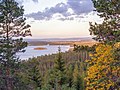
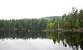
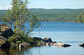
| Location | Arvika Municipality, Värmland County, Sweden | ||||
| Area |
| ||||
| Elevation above sea level |
| ||||
 | |||||
Media in category "Övre Gla"
The following 9 files are in this category, out of 9 total.
-
 Glasjöarna.jpg 2,007 × 1,505; 1.02 MB
-
 Övre Gla4.JPG 2,877 × 1,734; 1.96 MB
-
 Övre Gla5.JPG 2,934 × 1,911; 2.98 MB
-
 Övre Gla6.JPG 2,510 × 1,877; 2.94 MB
-
 Övre Gla7.JPG 2,958 × 1,837; 2.6 MB
-
 ÖvreGla1.JPG 2,611 × 1,895; 4.1 MB
-
 ÖvreGla2.JPG 2,911 × 1,853; 3.12 MB
-
 ÖvreGla3.JPG 2,911 × 1,865; 2.95 MB
-
 ÖvreGla4.JPG 2,478 × 1,576; 2.38 MB


