Category:1745
Here nagîvasyonê
Here lêgerînê
| ◀ 1740s ▶ (sedsala 18‑an, hezarsala 2‑an) |
|---|
| ◀ 1740 · 1741 · 1742 · 1743 · 1744 · 1745 · 1746 · 1747 · 1748 · 1749 ▶ |

Sal | |||||
| Medya bar bike | |||||
| Mînakek ji bo |
| ||||
|---|---|---|---|---|---|
| Beşek ji | |||||
| Dem |
| ||||
| Berî wê | |||||
| Piştî wê | |||||
| |||||
Binkategorî
Di vê kategoriyê de 11 binkategorî hene. Jêr 11 binkategorî tên nîşandan.
*
+
M
Medya di kategoriya "1745" de
Di vê kategoriyê de 55 dane hene. Jêr 55 dane tên nîşandan.
-
 2007-Dirmstein-Kirchgasse02.jpg 2832 x 2128; 1,06 MB
-

-
-

-
 Ado Viennensis Martyrologium.jpg 478 x 700; 124 KB
-
 AMH-2481-NA Ground plan of the fortifications at the Cape of Good Hope.jpg 2400 x 1683; 371 KB
-
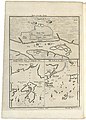
 AMH-7871-KB Bird's eye view of Loango.jpg 2400 x 1777; 1,37 MB
-
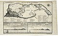
 AMH-7872-KB Map of Angola, Kongo and Benguela.jpg 2400 x 1869; 897 KB
-
 AMH-7896-KB Map of the west coast of Africa, near Popo.jpg 2400 x 1758; 647 KB
-
 AMH-7897-KB Bird's eye view of the kingdom of Whidah.jpg 2400 x 1777; 923 KB
-

-
 AMH-7899-KB Bird's eye view of the European trading stations in Sabi.jpg 2400 x 1502; 947 KB
-
 AMH-7900-KB Houses in Benin.jpg 1779 x 2400; 899 KB
-
 AMH-7901-KB Map of the bay of Kabinda and the mouth of the Congo river.jpg 1751 x 2400; 605 KB
-

-
 AMH-7904-KB Triumphal arch in Kanton.jpg 1749 x 2400; 749 KB
-

-
 AMH-8109-KB Count Daniel da Silva of Sogno.jpg 1717 x 2400; 1017 KB
-
 AMH-8157-KB Two views of the fort at Cape Corso.jpg 2400 x 1556; 976 KB
-
 AMH-8158-KB Prospect of the island of Goeree.jpg 1781 x 2400; 680 KB
-
 AMH-8159-KB Map of the island of Goeree and two views of Cape Verde.jpg 2400 x 1522; 863 KB
-
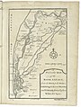
 AMH-8160-KB Map of the regions between the Senegal and Gambra rivers.jpg 1774 x 2400; 648 KB
-
 AMH-8161-KB Views of Cape Verde and Rufisco.jpg 2400 x 1803; 783 KB
-

-
 AMH-8163-KB Map of the island of Sanaga or St. Louis.jpg 2400 x 1351; 526 KB
-
 AMH-8164-KB Map of the mouth of the Senegal River.jpg 2400 x 1380; 546 KB
-
 AMH-8165-KB Map of the Senegal River.jpg 1809 x 2400; 721 KB
-
 AMH-8167-KB Map of the coast of Sierra Leone.jpg 1821 x 2400; 673 KB
-

-

-
 AMH-8170-KB Map of the Gold Coast.jpg 2400 x 1377; 667 KB
-

-
 AMH-8172-KB View of Fort Badenstein at Boutri and Fort Sebastian at Shama.jpg 2400 x 1839; 939 KB
-
 AMH-8173-KB View and plan of the fort of Groot Frederiksburg at Pokesoe.jpg 2400 x 1844; 912 KB
-
 AMH-8174-KB Views of the forts at Dickscove and Sakkundi.jpg 2400 x 1692; 1,1 MB
-
 AMH-8176-KB View of Fort Amsterdam at Kormantijn and Fort Royal at Manfro.jpg 2400 x 1808; 916 KB
-
 AMH-8177-KB View of the English fort at Anamabou and of Fort Nassau at Mouri.jpg 2400 x 1471; 1015 KB
-
 AMH-8178-KB View of the English and Dutch forts at Akkra, seen from the north.jpg 2400 x 1629; 1005 KB
-

-
 AMH-8181-KB Three charts of the Chinese coast near Kanton (cropped).jpg 1536 x 2048; 653 KB
-
 AMH-8181-KB Three charts of the Chinese coast near Kanton.jpg 1715 x 2400; 759 KB
-
 AMH-8183-KB Imperial Hall of Audience in Peking.jpg 2400 x 1545; 888 KB
-
 AMH-8184-KB View of Hocsieu.jpg 2400 x 1217; 806 KB
-
 Billet pour le bal 1745.jpg 560 x 444; 114 KB
-
 Casal-1745.jpg 694 x 539; 98 KB
-
 Fregate corsaire la Sainte Genevieve en 1745.jpg 1102 x 706; 107 KB
-
 Friedrich von Graffen Medaille.jpg 3281 x 1705; 1,36 MB
-
 Gstk.png 1101 x 1195; 139 KB
-

-
 Oroonoko cropped traduction françcais.JPG 304 x 441; 37 KB
-

-
 Rusovce 06 02.jpg 2304 x 3072; 2,29 MB
-
 Saint-Maime, chapelle Sainte-Agathe, clé de voûte 1745.JPG 4608 x 3456; 5,97 MB
-
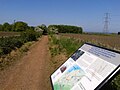 The Battlefield, Prestonpans.jpg 1024 x 768; 142 KB
-
 Włocławek-Kościół Św. Jana-Daty.JPG 3264 x 2448; 3,89 MB


_-_Foto_Giovanni_Dall%27Orto,_7_ottobre_2015.jpg)


.jpg)


