Category:17th-century maps of the Atlantic Ocean
Jump to navigation
Jump to search
Subcategories
This category has the following 18 subcategories, out of 18 total.
Media in category "17th-century maps of the Atlantic Ocean"
The following 30 files are in this category, out of 30 total.
-
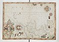
 Map of Africa(1600) south west.jpg 800 × 600; 154 KB
-
-
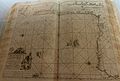
 Brazil and Central Atlantic RMG S0013-001.jpg 1,280 × 804; 1.38 MB
-

-
 Bordeaux-P1080802.jpg 4,216 × 2,856; 3.95 MB
-
 A generall chart of the Western Ocean - Mount and Page - btv1b53168630m.jpg 7,483 × 5,928; 7.51 MB
-
 A new Generall Chart for the West Indies of Wrights Projection - btv1b531686297.jpg 7,510 × 6,005; 7.66 MB
-
 America. R 2= 22. Pièce 39.jpg 12,352 × 9,464; 24.1 MB
-
 Atlantique central - btv1b53168526h (1 of 2).jpg 8,489 × 5,416; 5.89 MB
-

-
 Bay of Biscay - Mount & Page - btv1b531531922 (1 of 2).jpg 6,350 × 7,360; 5.27 MB
-
 Belgii novi, Angliæ novæ, et partis Virginiæ novissima delineatio. R 2= 22. Pièce 43.jpg 8,632 × 7,216; 12.6 MB
-
 Carte Generale des costes de l'Europe - no-nb krt 00761.jpg 10,770 × 7,497; 23.51 MB
-

-

-
 De cust van Barbaria streckende van C. S. Vincent tot C. Verde. R 2= 22. Pièce 35.jpg 9,032 × 7,048; 10.25 MB
-
 Mar di Æthiopia vulgo Oceanus Æthiopicus. R 2= 22. Pièce 38.jpg 8,864 × 7,088; 11.35 MB
-
 Mar del Nort (IA McGillLibrary-123682-2123).pdf 1,979 × 1,739; 6.39 MB
-
 Pas caert van Nieu Nederland, Virginia en Nieu Engelant. R 2= 22. Pièce 42.jpg 8,872 × 7,088; 11.81 MB
-

-

-

-
 Paskaart van Guinea van C. Verde tot R. de Galion. R 2= 22. Pièce 36.jpg 8,800 × 7,048; 9.87 MB
-
 Paskaart van Guinea, Brasilien en Westindien. R 2= 22. Pièce 45.jpg 15,194 × 12,674; 32.59 MB
-

-

-

-
 The Virginia Company chart (NYPL Hades-118534-54658).jpg 4,938 × 2,854; 16.16 MB
-

-

_south_west.jpg)
.jpg)

.jpg)


.jpg)
.jpg)
.jpg)


_-_attribu%C3%A9_%C3%A0_Albernaz_I,_Joao_Teixeira_-_btv1b53028106n_(1_of_8).jpg)
.jpg)


.jpg)
.jpg)
.jpg)