Category:1880s maps of Washington, D.C.
Jump to navigation
Jump to search
States of the United States: Alabama · Alaska · Arizona · Arkansas · California · Colorado · Connecticut · Delaware · Florida · Georgia · Hawaii · Idaho · Illinois · Indiana · Iowa · Kansas · Kentucky · Louisiana · Maine · Maryland · Massachusetts · Michigan · Minnesota · Mississippi · Missouri · Montana · Nebraska · Nevada · New Hampshire · New Jersey · New Mexico · New York · North Carolina · North Dakota · Ohio · Oklahoma · Oregon · Pennsylvania · Rhode Island · South Carolina · South Dakota · Tennessee · Texas · Utah · Vermont · Virginia · Washington · West Virginia · Wisconsin · Wyoming – Washington, D.C.
Puerto Rico
Puerto Rico
Subcategories
This category has the following 5 subcategories, out of 5 total.
- 1884 maps of Washington, D.C. (34 F)
- 1885 maps of Washington, D.C. (28 F)
- 1886 maps of Washington D.C. (17 F)
Media in category "1880s maps of Washington, D.C."
The following 12 files are in this category, out of 12 total.
-

-
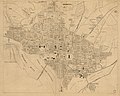 (Map of the city of Washington and suburbs, District of Columbia). LOC 88693461.jpg 12,665 × 10,170; 16.91 MB
-
 (Map of the city of Washington and suburbs, District of Columbia). LOC 88693461.tif 12,665 × 10,170; 368.51 MB
-
 271 of 'The Youth's History of the United States, etc' (11189768223).jpg 2,029 × 2,651; 1.56 MB
-
 Edgewood Estate, 1887.jpg 1,192 × 833; 278 KB
-

-

-
 Crest line of Fort Totten - NARA - 122207147.jpg 6,600 × 3,783; 772 KB
-
 Fort Totten - Section Through Bombproof - NARA - 122207149.jpg 5,296 × 3,308; 609 KB
-
 Fort Totten Scarp Revetment - NARA - 122207151.jpg 8,919 × 4,112; 2.77 MB
-
 Hopkins map 1887.jpg 719 × 1,279; 189 KB
-
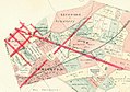
 Mount Pleasant, 1887 (493941087) (2).jpg 968 × 643; 212 KB

._LOC_88693461.jpg)
.jpg)


_(2).jpg)