Category:Aérotrain in Limours
Jump to navigation
Jump to search
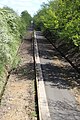
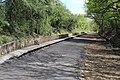
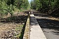
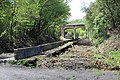
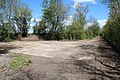
Français : Une partie de la voie expérimentale de l'Aérotrain, après avoir longtemps été laissée à l'abandon, a été aménagée en voie verte sur la commune de Limours en France (voir L’Aérotrain de Jean Bertin).
English: Part of the experimental path of the Aérotrain (SkyTrain), after having long been neglected, has been converted into a cycle track in the town of Limours, France (see L’Aérotrain de Jean Bertin).
| Object location | | View all coordinates using: OpenStreetMap |
|---|
Media in category "Aérotrain in Limours"
The following 57 files are in this category, out of 57 total.
-

-
 D988 au-dessus de la voie expérimentale de l'Aérotrain le 1er mai 2012 à Limours.jpg 5,184 × 3,456; 7.49 MB
-

-
 Voie expérimentale de l'Aérotrain le 1er mai 2012 à Limours 01.jpg 3,456 × 5,184; 10.71 MB
-
 Voie expérimentale de l'Aérotrain le 1er mai 2012 à Limours 02.jpg 3,456 × 5,184; 11.85 MB
-
 Voie expérimentale de l'Aérotrain le 1er mai 2012 à Limours 03.jpg 3,456 × 5,184; 11.84 MB
-
 Voie expérimentale de l'Aérotrain le 1er mai 2012 à Limours 04.jpg 3,456 × 5,184; 14.71 MB
-
 Voie expérimentale de l'Aérotrain le 1er mai 2012 à Limours 05.jpg 5,184 × 3,456; 8.65 MB
-
 Voie expérimentale de l'Aérotrain le 1er mai 2012 à Limours 06.jpg 5,184 × 3,456; 11.87 MB
-
 Voie expérimentale de l'Aérotrain le 1er mai 2012 à Limours 07.jpg 5,184 × 3,456; 10.84 MB
-
 Voie expérimentale de l'Aérotrain le 1er mai 2012 à Limours 08.jpg 5,184 × 3,456; 10.67 MB
-
 Voie expérimentale de l'Aérotrain le 1er mai 2012 à Limours 09.jpg 5,184 × 3,456; 5.68 MB
-
 Voie expérimentale de l'Aérotrain le 1er mai 2012 à Limours 10.jpg 5,184 × 3,456; 8.45 MB
-
 Voie expérimentale de l'Aérotrain le 1er mai 2012 à Limours 11.jpg 5,184 × 3,456; 12.52 MB
-
 Voie expérimentale de l'Aérotrain le 1er mai 2012 à Limours 12.jpg 5,184 × 3,456; 13.98 MB
-
 Voie expérimentale de l'Aérotrain le 1er mai 2012 à Limours 13.jpg 5,184 × 3,456; 8.98 MB
-
 Voie expérimentale de l'Aérotrain le 1er mai 2012 à Limours 14.jpg 5,184 × 3,456; 11.57 MB
-
 Voie expérimentale de l'Aérotrain le 1er mai 2012 à Limours 15.jpg 5,184 × 3,456; 11.79 MB
-
 Voie expérimentale de l'Aérotrain le 1er mai 2012 à Limours 16.jpg 5,184 × 3,456; 10.19 MB
-
 Voie expérimentale de l'Aérotrain le 1er mai 2012 à Limours 17.jpg 5,184 × 3,456; 11.72 MB
-
 Voie expérimentale de l'Aérotrain le 1er mai 2012 à Limours 18.jpg 5,184 × 3,456; 7.09 MB
-
 Voie expérimentale de l'Aérotrain le 1er mai 2012 à Limours 19.jpg 3,456 × 5,184; 10.09 MB
-
 Voie expérimentale de l'Aérotrain le 1er mai 2012 à Limours 20.jpg 5,184 × 3,456; 13.39 MB
-
 Voie expérimentale de l'Aérotrain le 1er mai 2012 à Limours 21.jpg 5,184 × 3,456; 13.23 MB
-
 Voie expérimentale de l'Aérotrain le 1er mai 2012 à Limours 22.jpg 3,456 × 5,184; 7.84 MB
-
 Voie expérimentale de l'Aérotrain le 1er mai 2012 à Limours 23.jpg 3,456 × 5,184; 12.33 MB
-
 Voie expérimentale de l'Aérotrain le 1er mai 2012 à Limours 24.jpg 5,184 × 3,456; 8.52 MB
-
 Voie expérimentale de l'Aérotrain le 1er mai 2012 à Limours 25.jpg 5,184 × 3,456; 12.42 MB
-
 Voie expérimentale de l'Aérotrain le 1er mai 2012 à Limours 26.jpg 5,184 × 3,456; 13.23 MB
-
 Voie expérimentale de l'Aérotrain le 1er mai 2012 à Limours 27.jpg 3,456 × 5,184; 13.81 MB
-
 Voie expérimentale de l'Aérotrain le 1er mai 2012 à Limours 28.jpg 5,184 × 3,456; 4.62 MB
-
 Voie expérimentale de l'Aérotrain le 1er mai 2012 à Limours Algues 01.jpg 5,184 × 3,456; 9.1 MB
-
 Voie expérimentale de l'Aérotrain le 1er mai 2012 à Limours Algues 02.jpg 5,184 × 3,456; 6.97 MB
-
 Voie expérimentale de l'Aérotrain le 1er mai 2012 à Limours Algues 03.jpg 5,184 × 3,456; 9.04 MB
-
 Voie expérimentale de l'Aérotrain le 1er mai 2012 à Limours Algues 04.jpg 5,184 × 3,456; 6.74 MB
-
 Voie expérimentale de l'Aérotrain le 1er mai 2012 à Limours Algues 05.jpg 5,184 × 3,456; 6.3 MB
-
 Voie expérimentale de l'Aérotrain le 1er mai 2012 à Limours Algues 06.jpg 5,184 × 3,456; 6.89 MB
-
 Voie expérimentale de l'Aérotrain le 1er mai 2012 à Limours Algues 07.jpg 5,184 × 3,456; 7.62 MB
-
 Voie expérimentale de l'Aérotrain le 1er mai 2012 à Limours Algues 08.jpg 5,184 × 3,456; 6.94 MB
-
 Voie expérimentale de l'Aérotrain le 1er mai 2012 à Limours Algues 09.jpg 5,184 × 3,456; 8.95 MB
-
 Voie expérimentale de l'Aérotrain le 1er mai 2012 à Limours Algues 10.jpg 5,184 × 3,456; 9.22 MB
-
 Voie expérimentale de l'Aérotrain le 1er mai 2012 à Limours Algues 11.jpg 5,184 × 3,456; 8.02 MB
-
 Voie expérimentale de l'Aérotrain le 1er mai 2012 à Limours Algues 12.jpg 5,184 × 3,456; 9.86 MB
-
 Voie expérimentale de l'Aérotrain le 1er mai 2012 à Limours Algues 13.jpg 5,184 × 3,456; 7.76 MB
-
 Voie expérimentale de l'Aérotrain le 1er mai 2012 à Limours Algues 14.jpg 5,184 × 3,456; 6.85 MB
-
 Voie expérimentale de l'Aérotrain le 1er mai 2012 à Limours Champ de Colza 1.jpg 3,456 × 5,184; 9.39 MB
-
 Voie expérimentale de l'Aérotrain le 1er mai 2012 à Limours Champ de Colza 2.jpg 5,184 × 3,456; 4.52 MB
-
 Voie expérimentale de l'Aérotrain le 1er mai 2012 à Limours Champ de Colza 3.jpg 5,184 × 3,456; 12.47 MB
-
 Voie expérimentale de l'Aérotrain le 1er mai 2012 à Limours Champ de Colza 4.jpg 5,184 × 3,456; 12.96 MB
-
 Voie expérimentale de l'Aérotrain le 1er mai 2012 à Limours Champ de Colza 5.jpg 5,184 × 3,456; 8.31 MB
-
 Voie expérimentale de l'Aérotrain le 1er mai 2012 à Limours Champ de Colza 6.jpg 5,184 × 3,456; 11.72 MB
-
 Voie verte du pays de Limours le 12 août 2016 - 37.jpg 5,184 × 3,456; 8.05 MB
-
 Voie verte du pays de Limours le 12 août 2016 - 39.jpg 5,184 × 3,456; 8.77 MB
-
 Voie verte du pays de Limours le 12 août 2016 - 40.jpg 5,184 × 3,456; 10.47 MB
-
 Voie verte du pays de Limours le 12 août 2016 - 41.jpg 5,184 × 3,456; 9.53 MB
-
 Voie verte du pays de Limours le 12 août 2016 - 42.jpg 5,184 × 3,456; 10.47 MB
-
 Voie verte du pays de Limours le 12 août 2016 - 43.jpg 5,184 × 3,456; 11.18 MB


