Category:Aerial photographs of Lake Superior
Jump to navigation
Jump to search
Media in category "Aerial photographs of Lake Superior"
The following 14 files are in this category, out of 14 total.
-
 4P5C8002 (14068760980).jpg 2,121 × 1,414; 2.43 MB
-
 4P5C8395 (14275628133).jpg 2,121 × 1,414; 3.37 MB
-
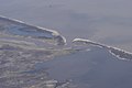 Bad River mouth.jpg 3,008 × 2,000; 2.63 MB
-
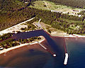 Big Bay Michigan aerial view.jpg 1,500 × 1,199; 634 KB
-
 Caribouisland.jpg 1,024 × 768; 179 KB
-
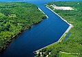 Keweenaw Waterway north end.jpg 1,500 × 1,049; 599 KB
-

-

-

-

-
 Silver Islet ON.JPG 2,000 × 1,333; 818 KB
-
 SplitRockLighthouse AerialView.jpg 743 × 499; 239 KB
-

-
 Two Harbors Minnesota aerial view.jpg 1,500 × 1,050; 674 KB
.jpg)
.jpg)


