Category:Amalienstraße A 33 (Neuburg an der Donau)
Jump to navigation
Jump to search
| Object location | | View all coordinates using: OpenStreetMap |
|---|
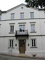
building in Neuburg an der Donau, Upper Bavaria, Germany  | |||||
| Upload media | |||||
| Instance of | |||||
|---|---|---|---|---|---|
| Location | Neuburg an der Donau, Neuburg-Schrobenhausen, Upper Bavaria, Bavaria, Germany | ||||
| Street address |
| ||||
| Heritage designation | |||||
 | |||||
This is the category of the Bavarian Baudenkmal (cultural heritage monument) with the ID D-1-85-149-15 (Wikidata)
|
Deutsch: Ehemaliges Wohnhausm, jetzt Biohistoricum, spätklassizistischer Bau mit Mittelrisalit, auf Unterbauten des inneren Obertores des 16. Jahrhunderts errichtet, erbaut von Joseph Hiller, 1880.
Amalienstraße A 33,Neuburg an der Donau, Bayern, Deutschland
Amalienstraße A 33,Neuburg an der Donau, Bayern, Deutschland
Media in category "Amalienstraße A 33 (Neuburg an der Donau)"
The following 2 files are in this category, out of 2 total.
-
 Amalienstr. A33 Neuburg-1.jpg 1,944 × 2,592; 679 KB
-
 Amalienstr. A33 Neuburg-2.jpg 1,944 × 2,592; 562 KB
