Category:Ataria Interpretation Centre of the Salburua wetlands
Jump to navigation
Jump to search
Euskara: Ataria (Salburua)
English: Ataria Interpretation Centre — of the Salburua Wetlands.
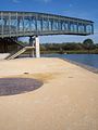
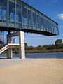
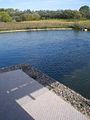
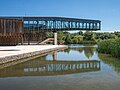
- Located in the Salburua district outside Vitoria-Gasteiz in Álava-Araba province, Basque Autonomous Community, northern Spain.
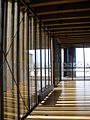
- Contemporay building includes an exhibition area, café, auditorium, and cantilevered observation deck over a lagoon of the wetlands.
| Object location | | View all coordinates using: OpenStreetMap |
|---|
wetlands interpretive center in Salburua, Spain  | |||||
| Upload media | |||||
| Instance of |
| ||||
|---|---|---|---|---|---|
| Location | |||||
| Heritage designation | |||||
| Inception |
| ||||
 | |||||
Media in category "Ataria Interpretation Centre of the Salburua wetlands"
The following 50 files are in this category, out of 50 total.
-
 Ataria.jpg 800 × 496; 101 KB
-
 Vitoria - Centro Ataria y balsas de Salburua 22.jpg 1,280 × 928; 137 KB
-
 Vitoria - Centro Ataria y balsas de Salburua 30.jpg 960 × 1,280; 211 KB
-
 Downpour at Ataria, Basque Country, Spain (PPL3-Altered) julesvernex2.jpg 4,303 × 2,992; 3.74 MB
-

-
 Jules and Gabriel at Ataria, Basque Country, Spain (PPL1-Corrected) julesvernex2.jpg 5,752 × 4,000; 4.45 MB
-
 Parque de Salburua - panoramio.jpg 2,048 × 1,152; 566 KB
-
 TEDxVitoriaGasteiz - Duality.jpg 3,783 × 3,018; 5.93 MB
-
 Vitoria - Centro Ataria y balsas de Salburua 02.jpg 960 × 1,280; 146 KB
-
 Vitoria - Centro Ataria y balsas de Salburua 03.jpg 960 × 1,280; 147 KB
-
 Vitoria - Centro Ataria y balsas de Salburua 04.jpg 960 × 1,280; 107 KB
-
 Vitoria - Centro Ataria y balsas de Salburua 05.jpg 960 × 1,280; 153 KB
-
 Vitoria - Centro Ataria y balsas de Salburua 06.jpg 960 × 1,280; 128 KB
-
 Vitoria - Centro Ataria y balsas de Salburua 07.jpg 960 × 1,280; 207 KB
-
 Vitoria - Centro Ataria y balsas de Salburua 08.jpg 960 × 1,280; 152 KB
-
 Vitoria - Centro Ataria y balsas de Salburua 09.jpg 960 × 1,280; 134 KB
-
 Vitoria - Centro Ataria y balsas de Salburua 10.jpg 960 × 1,280; 128 KB
-
 Vitoria - Centro Ataria y balsas de Salburua 11.jpg 1,280 × 960; 205 KB
-
 Vitoria - Centro Ataria y balsas de Salburua 12.jpg 960 × 1,280; 160 KB
-
 Vitoria - Centro Ataria y balsas de Salburua 13.jpg 960 × 1,280; 167 KB
-
 Vitoria - Centro Ataria y balsas de Salburua 14.jpg 960 × 1,280; 83 KB
-
 Vitoria - Centro Ataria y balsas de Salburua 15.jpg 1,280 × 960; 207 KB
-
 Vitoria - Centro Ataria y balsas de Salburua 16.jpg 1,280 × 960; 263 KB
-
 Vitoria - Centro Ataria y balsas de Salburua 17.jpg 1,280 × 960; 267 KB
-
 Vitoria - Centro Ataria y balsas de Salburua 18.jpg 960 × 1,280; 203 KB
-
 Vitoria - Centro Ataria y balsas de Salburua 19.jpg 960 × 1,280; 172 KB
-
 Vitoria - Centro Ataria y balsas de Salburua 20.jpg 960 × 1,280; 93 KB
-
 Vitoria - Centro Ataria y balsas de Salburua 21.jpg 960 × 1,280; 128 KB
-
 Vitoria - Centro Ataria y balsas de Salburua 23.jpg 1,280 × 960; 134 KB
-
 Vitoria - Centro Ataria y balsas de Salburua 25.jpg 960 × 1,280; 149 KB
-
 Vitoria - Centro Ataria y balsas de Salburua 26.jpg 960 × 1,280; 141 KB
-
 Vitoria - Centro Ataria y balsas de Salburua 27.jpg 960 × 1,280; 175 KB
-
 Vitoria - Centro Ataria y balsas de Salburua 28.jpg 960 × 1,280; 126 KB
-
 Vitoria - Centro Ataria y balsas de Salburua 29.jpg 960 × 1,280; 126 KB
-
 Vitoria - Centro Ataria y balsas de Salburua 31.jpg 1,280 × 960; 116 KB
-
 Vitoria - Centro Ataria y balsas de Salburua 33.jpg 1,280 × 960; 129 KB
-
 Vitoria - Centro Ataria y balsas de Salburua 34.jpg 954 × 1,184; 90 KB
-
 Vitoria - Centro Ataria y balsas de Salburua 35.jpg 1,280 × 960; 123 KB
-
 Vitoria - Centro Ataria y balsas de Salburua 36.jpg 960 × 1,280; 166 KB
-
 Vitoria - Centro Ataria y balsas de Salburua 37.jpg 960 × 1,280; 147 KB
-
 Vitoria - Centro Ataria y balsas de Salburua 38.jpg 1,280 × 960; 163 KB
-
 Vitoria - Salburua - Ataria 01.jpg 4,442 × 3,335; 9.52 MB
-
 Vitoria - Salburua - Ataria 02.jpg 4,387 × 3,318; 6.55 MB
-
 Vitoria - Salburua - Ataria 03.jpg 3,133 × 4,172; 7.5 MB
-
 Vitoria - Salburua - Ataria 04 edited.jpg 3,723 × 2,793; 14.26 MB
-
 Vitoria - Salburua - Ataria 04.jpg 4,592 × 3,231; 8.07 MB
-
 Vitoria - Salburua - Ataria 05.jpg 3,228 × 4,299; 9.33 MB
-
 Vitoria - Salburua - Ataria 06.jpg 3,988 × 2,646; 9.65 MB
-
 Vitoria - Centro Ataria y balsas de Salburua 01.jpg 1,280 × 960; 126 KB
-
 Vitoria - Centro Ataria y balsas de Salburua 24.jpg 960 × 1,280; 131 KB


_julesvernex2.jpg)
_at_Ataria,_Basque_Country,_Spain_(PPL1-Corrected)_julesvernex2.jpg)
_julesvernex2.jpg)


