Category:Bear Mountain Bridge Road
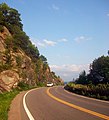
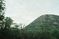
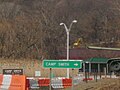
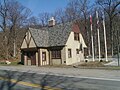
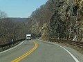
Bear Mountain Bridge Road (commonly referred to as the "goat trail") is a four mile, two-lane mountainous section of US 6/202 from the west approach to Bear Mountain Bridge to Annsville Circle, in the Town of Cortlandt, New York, United States.It winds around the steep, rocky slopes of Anthony's Nose, the southernmost peak of the Hudson Highlands on the east side of the Hudson River, and was listed on the National Register of Historic Places on November 23, 1982. Included as part of this designation is a former Tudor-revival toll house northwest of the entrance to Camp Smith.
|
This is a category about a place or building that is listed on the National Register of Historic Places in the United States of America. Its reference number is 82001266. |
 | |||||
| Upload media | |||||
| Instance of | |||||
|---|---|---|---|---|---|
| Location | Cortlandt, Westchester County, New York | ||||
| Heritage designation | |||||
 | |||||
Media in category "Bear Mountain Bridge Road"
The following 66 files are in this category, out of 66 total.
-
 Bear Mountain Bridge Road II.jpg 7,364 × 4,915; 21.64 MB
-
 Bear Mountain Bridge Road.jpg 4,915 × 7,364; 22.32 MB
-
 Bear Mountain Bridge Toll House.jpg 878 × 670; 251 KB
-
 Bear Mountain Road.jpg 2,748 × 3,020; 1.18 MB
-
 Hudson River - panoramio - Alistair Cunningham.jpg 1,024 × 768; 322 KB
-
 MapShowingAProposedRoadToBearMountain1923NYT.png 1,469 × 1,348; 85 KB
-
 Palisades Interstate Parkway I.jpg 7,364 × 4,915; 21.71 MB
-
 Run12 (5682362196).jpg 1,280 × 853; 958 KB
-
 U.S. Route 6 in New York (state) PICT0406 (3284877569).jpg 1,600 × 1,200; 398 KB
-
 U.S. Route 6 in New York (state) PICT0407 (3284877745).jpg 1,600 × 1,200; 307 KB
-
 U.S. Route 6 in New York (state) PICT0409 (3284878071).jpg 1,600 × 1,200; 315 KB
-
 U.S. Route 6 in New York (state) PICT0410 (3284878259).jpg 1,600 × 1,200; 340 KB
-
 U.S. Route 6 in New York (state) PICT0412 (3284878663).jpg 1,600 × 1,200; 288 KB
-
 U.S. Route 6 in New York (state) PICT0413 (3285696796).jpg 1,600 × 1,200; 365 KB
-
 U.S. Route 6 in New York (state) PICT0415 (3284879115).jpg 1,600 × 1,200; 535 KB
-
 U.S. Route 6 in New York (state) PICT0416 (3284879341).jpg 1,600 × 1,200; 441 KB
-
 U.S. Route 6 in New York (state) PICT0417 (3285697612).jpg 1,600 × 1,200; 600 KB
-
 U.S. Route 6 in New York (state) PICT0418 (3285697778).jpg 1,600 × 1,200; 271 KB
-
 U.S. Route 6 in New York (state) PICT0419 (3284879843).jpg 1,600 × 1,200; 530 KB
-
 U.S. Route 6 in New York (state) PICT0420 (3285698274).jpg 1,600 × 1,200; 553 KB
-
 U.S. Route 6 in New York (state) PICT0421 (3285698632).jpg 1,600 × 1,200; 694 KB
-
 U.S. Route 6 in New York (state) PICT0422 (3285698754).jpg 1,600 × 1,200; 329 KB
-
 U.S. Route 6 in New York (state) PICT0423 (3284880741).jpg 1,600 × 1,200; 578 KB
-
 U.S. Route 6 in New York (state) PICT0424 (3285699154).jpg 1,600 × 1,200; 503 KB
-
 U.S. Route 6 in New York (state) PICT0425 (3284881131).jpg 1,600 × 1,200; 413 KB
-
 U.S. Route 6 in New York (state) PICT0426 (3284881361).jpg 1,600 × 1,200; 376 KB
-
 U.S. Route 6 in New York (state) PICT0427 (3285700172).jpg 1,600 × 1,200; 470 KB
-
 U.S. Route 6 in New York (state) PICT0428 (3284882117).jpg 1,600 × 1,200; 571 KB
-
 U.S. Route 6 in New York (state) PICT0429 (3284882253).jpg 1,600 × 1,200; 243 KB
-
 U.S. Route 6 in New York (state) PICT0430 (3284882433).jpg 1,600 × 1,200; 488 KB
-
 U.S. Route 6 in New York (state) PICT0431 (3284882731).jpg 1,600 × 1,200; 657 KB
-
 U.S. Route 6 in New York (state) PICT0432 (3284882887).jpg 1,600 × 1,200; 526 KB
-
 U.S. Route 6 in New York (state) PICT0433 (3285701298).jpg 1,600 × 1,200; 457 KB
-
 U.S. Route 6 in New York (state) PICT0436 (3285701906).jpg 1,600 × 1,200; 366 KB
-
 U.S. Route 6 in New York (state) PICT0437 (3285702098).jpg 1,600 × 1,200; 398 KB
-
 U.S. Route 6 in New York (state) PICT0438 (3284884041).jpg 1,600 × 1,200; 411 KB
-
 U.S. Route 6 in New York (state) PICT0439 (3284884221).jpg 1,600 × 1,200; 453 KB
-
 U.S. Route 6 in New York (state) PICT0440 (3285702882).jpg 1,226 × 1,200; 1.06 MB
-
 U.S. Route 6 in New York (state) PICT0441 (3284884741).jpg 1,600 × 1,200; 436 KB
-
 U.S. Route 6 in New York (state) PICT0442 (3284884901).jpg 1,600 × 1,200; 415 KB
-
 U.S. Route 6 in New York (state) PICT0443 (3284885063).jpg 1,600 × 1,200; 369 KB
-
 U.S. Route 6 in New York (state) PICT0444 (3285703502).jpg 1,600 × 1,200; 368 KB
-
 U.S. Route 6 in New York (state) PICT0445 (3285703646).jpg 1,600 × 1,200; 363 KB
-
 U.S. Route 6 in New York (state) PICT0446 (3285703774).jpg 1,600 × 1,200; 399 KB
-
 U.S. Route 6 in New York (state) PICT0447 (3285703884).jpg 1,600 × 1,200; 246 KB
-
 U.S. Route 6 in New York (state) PICT0448 (3285703996).jpg 1,600 × 1,200; 277 KB
-
 U.S. Route 6 in New York (state) PICT0449 (3285704166).jpg 1,600 × 1,200; 331 KB
-
 U.S. Route 6 in New York (state) PICT0450 (3285704334).jpg 1,600 × 1,200; 327 KB
-
 U.S. Route 6 in New York (state) PICT0451 (3284886009).jpg 1,600 × 1,200; 242 KB
-
 U.S. Route 6 in New York (state) PICT0452 (3285704552).jpg 1,600 × 1,200; 367 KB
-
 U.S. Route 6 in New York (state) PICT0453 (3285704744).jpg 1,600 × 1,200; 275 KB
-
 U.S. Route 6 in New York (state) PICT0454 (3284886537).jpg 1,600 × 1,200; 392 KB
-
 U.S. Route 6 in New York (state) PICT0455 (3284886735).jpg 1,600 × 1,200; 473 KB
-
 U.S. Route 6 in New York (state) PICT0456 (3284886949).jpg 1,600 × 1,200; 474 KB
-
 U.S. Route 6 in New York (state) PICT0457 (3285705536).jpg 1,600 × 1,200; 398 KB
-
 U.S. Route 6 in New York (state) PICT0458 (3284887329).jpg 1,600 × 1,200; 333 KB
-
 U.S. Route 6 in New York (state) PICT0459 (3285705820).jpg 1,600 × 1,200; 355 KB
-
 U.S. Route 6 in New York (state) PICT0460 (3284887643).jpg 1,600 × 1,200; 363 KB
-
 U.S. Route 6 in New York (state) PICT0461 (3284887819).jpg 1,600 × 1,200; 407 KB
-
 U.S. Route 6 in New York (state) PICT0462 (3284887975).jpg 1,600 × 1,200; 342 KB
-
 U.S. Route 6 in New York (state) PICT0463 (3284888129).jpg 1,600 × 1,200; 398 KB
-
 U.S. Route 6 in New York (state) PICT0464 (3285706704).jpg 1,600 × 1,200; 370 KB
-
 US Route 6 - New York - 4292837358.jpg 640 × 480; 34 KB
-
 US Route 6 - New York - 4292837378.jpg 640 × 480; 48 KB
-
 US Route 6 - New York - 4292839546.jpg 1,024 × 768; 149 KB
-
 View of Bear Mountain from Bear Mountain Bridge Road.jpg 7,364 × 4,915; 24.66 MB


.jpg)
_PICT0406_(3284877569).jpg)
_PICT0407_(3284877745).jpg)
_PICT0409_(3284878071).jpg)
_PICT0410_(3284878259).jpg)
_PICT0412_(3284878663).jpg)
_PICT0413_(3285696796).jpg)
_PICT0415_(3284879115).jpg)
_PICT0416_(3284879341).jpg)
_PICT0417_(3285697612).jpg)
_PICT0418_(3285697778).jpg)
_PICT0419_(3284879843).jpg)
_PICT0420_(3285698274).jpg)
_PICT0421_(3285698632).jpg)
_PICT0422_(3285698754).jpg)
_PICT0423_(3284880741).jpg)
_PICT0424_(3285699154).jpg)
_PICT0425_(3284881131).jpg)
_PICT0426_(3284881361).jpg)
_PICT0427_(3285700172).jpg)
_PICT0428_(3284882117).jpg)
_PICT0429_(3284882253).jpg)
_PICT0430_(3284882433).jpg)
_PICT0431_(3284882731).jpg)
_PICT0432_(3284882887).jpg)
_PICT0433_(3285701298).jpg)
_PICT0436_(3285701906).jpg)
_PICT0437_(3285702098).jpg)
_PICT0438_(3284884041).jpg)
_PICT0439_(3284884221).jpg)
_PICT0440_(3285702882).jpg)
_PICT0441_(3284884741).jpg)
_PICT0442_(3284884901).jpg)
_PICT0443_(3284885063).jpg)
_PICT0444_(3285703502).jpg)
_PICT0445_(3285703646).jpg)
_PICT0446_(3285703774).jpg)
_PICT0447_(3285703884).jpg)
_PICT0448_(3285703996).jpg)
_PICT0449_(3285704166).jpg)
_PICT0450_(3285704334).jpg)
_PICT0451_(3284886009).jpg)
_PICT0452_(3285704552).jpg)
_PICT0453_(3285704744).jpg)
_PICT0454_(3284886537).jpg)
_PICT0455_(3284886735).jpg)
_PICT0456_(3284886949).jpg)
_PICT0457_(3285705536).jpg)
_PICT0458_(3284887329).jpg)
_PICT0459_(3285705820).jpg)
_PICT0460_(3284887643).jpg)
_PICT0461_(3284887819).jpg)
_PICT0462_(3284887975).jpg)
_PICT0463_(3284888129).jpg)
_PICT0464_(3285706704).jpg)


