Category:Blossin
Jump to navigation
Jump to search
| Object location | | View all coordinates using: OpenStreetMap |
|---|
village in Brandenburg state, Germany  | |||||
| Upload media | |||||
| Pronunciation audio | |||||
|---|---|---|---|---|---|
| Instance of |
| ||||
| Location | Heidesee, Dahme-Spreewald District, Brandenburg, Germany | ||||
| Population |
| ||||
| Area |
| ||||
| Elevation above sea level |
| ||||
 | |||||
Deutsch: Das Dorf Blossin gehört zur Gemeinde Heidesee , Landkreis Dahme-Spreewald , Land Brandenburg, Deutschland.
English: The village Blossin belongs to Heidesee municipality , Dahme-Spreewald district, Brandenburg state, Germany
Français : Le village de Blossin fait partie de la commune de Heidesee , arrondissement de Dahme-Spreewald , état fédéral de Brandebourg, Allemagne
Español: El pueblo de Blossin es parte del municipio de Heidesee , distrito de Dahme-Spreewald , estado federado de Brandeburgo, Alemania
Subcategories
This category has the following 2 subcategories, out of 2 total.
J
W
Media in category "Blossin"
The following 9 files are in this category, out of 9 total.
-
 Blossin Urmesstischblatt 3748 Friedersdorf 1841.jpg 728 × 1,374; 236 KB
-
 Blossin-Bruecke-1999.jpg 3,024 × 4,032; 5.48 MB
-
 Ehemalige Feuerwehr und Rat der Gemeinde Blossin 2019 SE.jpg 5,570 × 3,488; 6.04 MB
-
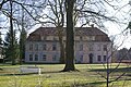 Heidesee Blossin Gutshaus.jpg 3,872 × 2,592; 2.1 MB
-
 Heidesee-Blossin Küchensee Blick nach Osten.jpg 4,032 × 3,024; 6.01 MB
-
 Heidesee-Blossin Weißer Berg Blick nach Nordwesten.jpg 4,032 × 3,024; 8.19 MB
-
 Restaurant Fischerhütte Blossin 2019 SW.jpg 2,688 × 1,520; 1.44 MB
-
 Wolziger See (Heidesee) 05.jpg 1,600 × 1,200; 561 KB
-
 Wolziger See (Heidesee) 06.jpg 1,600 × 1,200; 608 KB


_05.jpg)
_06.jpg)