Category:Broadwoodkelly
Jump to navigation
Jump to search
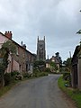
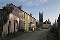
English: Broadwoodkelly is a village and civil parish in the West Devon district of Devon in England. According to the 2001 census it had a population of 218. The village is situated about north of Okehampton.
village in United Kingdom .jpg) | |||||
| Upload media | |||||
| Instance of | |||||
|---|---|---|---|---|---|
| Location | West Devon, Devon, South West England, England | ||||
 | |||||
Media in category "Broadwoodkelly"
The following 89 files are in this category, out of 89 total.
-

-
 A field of maize, Broadwoodkelly - geograph.org.uk - 3626503.jpg 1,024 × 768; 158 KB
-
 A long, low farm building at Barntown - geograph.org.uk - 3626439.jpg 1,024 × 768; 129 KB
-
 Approaching Fourways Cross - geograph.org.uk - 2818411.jpg 640 × 374; 60 KB
-
 Approaching Three Cross Way Cross - geograph.org.uk - 2811861.jpg 800 × 600; 498 KB
-
 Barn near Barntown Gate - geograph.org.uk - 2816621.jpg 640 × 462; 58 KB
-
 Barntown - geograph.org.uk - 2816652.jpg 640 × 434; 76 KB
-
 Barntown farm - geograph.org.uk - 3626437.jpg 1,024 × 768; 133 KB
-
 Barntown Lane - geograph.org.uk - 2816706.jpg 640 × 426; 54 KB
-
 Bridge over small stream south of Broadwoodkelly - geograph.org.uk - 3626527.jpg 1,024 × 768; 196 KB
-
 Broadwoodkelly church - geograph.org.uk - 3626481.jpg 1,024 × 768; 130 KB
-
 Broadwoodkelly church from the east - geograph.org.uk - 3626506.jpg 1,024 × 768; 100 KB
-
 Broadwoodkelly, by Alchey Down - geograph.org.uk - 329579.jpg 640 × 427; 247 KB
-
 Broadwoodkelly, by the church - geograph.org.uk - 329676.jpg 640 × 427; 176 KB
-
 Broadwoodkelly, Corstone Farm - geograph.org.uk - 329629.jpg 640 × 427; 288 KB
-
 Broadwoodkelly, east of the village - geograph.org.uk - 329645.jpg 640 × 427; 173 KB
-

-
-
 Broadwoodkelly, Middlecott - geograph.org.uk - 329688.jpg 640 × 427; 198 KB
-
 Broadwoodkelly, near Ingleigh Green - geograph.org.uk - 329693.jpg 640 × 427; 170 KB
-
 Broadwoodkelly, near Oakley House - geograph.org.uk - 329700.jpg 640 × 427; 271 KB
-
 Broadwoodkelly, public footpath - geograph.org.uk - 329569.jpg 640 × 427; 334 KB
-
 Broadwoodkelly, south to Dartmoor - geograph.org.uk - 98395.jpg 640 × 423; 90 KB
-
 Broadwoodkelly, Southdown Cross - geograph.org.uk - 329582.jpg 640 × 427; 116 KB
-

-
 Broadwoodkelly, towards Lower Moor - geograph.org.uk - 329630.jpg 640 × 427; 206 KB
-
 Broadwoodkelly, towards the village - geograph.org.uk - 329680.jpg 640 × 427; 235 KB
-
 Broadwoodkelly, with the church - geograph.org.uk - 3626512.jpg 768 × 1,024; 107 KB
-
 Bude Moor - geograph.org.uk - 3628076.jpg 1,024 × 768; 135 KB
-
 Bude Moor Cross - geograph.org.uk - 2815755.jpg 640 × 480; 97 KB
-
 Composite gate near Woodcroft Cross - geograph.org.uk - 2815912.jpg 640 × 478; 84 KB
-
 Copse close to Barntown - geograph.org.uk - 3626420.jpg 1,024 × 768; 106 KB
-

-
 Corstone Cross - the eastern corner - geograph.org.uk - 3628047.jpg 1,024 × 768; 211 KB
-
 Corstone Farm - geograph.org.uk - 3628062.jpg 1,024 × 768; 153 KB
-
 Cottages and church, Broadwoodkelly - geograph.org.uk - 2816505.jpg 640 × 371; 46 KB
-
 Cottages, Broadwoodkelly - geograph.org.uk - 2816387.jpg 640 × 433; 51 KB
-
 Cottages, Broadwoodkelly - geograph.org.uk - 2816473.jpg 640 × 434; 56 KB
-

-

-
 Crossing a stream near Redhays Farm - geograph.org.uk - 3626550.jpg 768 × 1,024; 293 KB
-
 Farm buildings and eggs for sale, Clarkestown - geograph.org.uk - 3626492.jpg 1,024 × 768; 103 KB
-
 Farm track in Clarkestown - geograph.org.uk - 3626488.jpg 1,024 × 768; 182 KB
-
 Field at Southdown - geograph.org.uk - 2816342.jpg 640 × 480; 64 KB
-
 Field by Alchey Down - geograph.org.uk - 2815932.jpg 640 × 480; 103 KB
-
 Field by Southdown Cross - geograph.org.uk - 2815955.jpg 640 × 465; 63 KB
-
 Field entranceway south of Broadwoodkelly - geograph.org.uk - 3626533.jpg 1,024 × 768; 256 KB
-

-
 Fields near Lower Moor - geograph.org.uk - 2815736.jpg 640 × 434; 74 KB
-
 Footbridge and path north of Broadwoodkelly - geograph.org.uk - 3626462.jpg 768 × 1,024; 299 KB
-
 Footbridge on path to Broadwoodkelly - geograph.org.uk - 3626457.jpg 1,024 × 768; 244 KB
-
 Footpath from Winkleigh to Broadwoodkelly - geograph.org.uk - 3626434.jpg 1,024 × 768; 131 KB
-
 Footpath to Broadwoodkelly from Barntown Lane - geograph.org.uk - 3626452.jpg 1,024 × 768; 191 KB
-
 Fourways Cross - geograph.org.uk - 2811883.jpg 800 × 600; 269 KB
-
 Gateway to Barntown - geograph.org.uk - 3626448.jpg 1,024 × 768; 168 KB
-
 Great Plantation near Winkleigh - geograph.org.uk - 3626403.jpg 1,024 × 768; 135 KB
-
 Hedgebank bounding Lower Moor - geograph.org.uk - 3628095.jpg 1,024 × 768; 151 KB
-
 House with oven and chimney on outside wall - geograph.org.uk - 3626477.jpg 1,024 × 768; 177 KB
-
 Lane and valley near Woodland House - geograph.org.uk - 2816746.jpg 640 × 480; 86 KB
-
 Lane near Chubhouse Farm - geograph.org.uk - 3424373.jpg 640 × 480; 86 KB
-
 Lane near Chubhouse Farm - geograph.org.uk - 479526.jpg 640 × 480; 117 KB
-
 Lane near Middlecott - geograph.org.uk - 2816719.jpg 640 × 414; 66 KB
-
 Lane through Splatt - geograph.org.uk - 2816365.jpg 640 × 356; 50 KB
-
 Lane to Broadwoodkelly - geograph.org.uk - 2816592.jpg 640 × 446; 72 KB
-
 Lane to Broadwoodkelly - geograph.org.uk - 2816613.jpg 640 × 414; 51 KB
-
 Meadow near Woodland House - geograph.org.uk - 2816761.jpg 640 × 450; 71 KB
-
 Multiple entrances, Clarkestown - geograph.org.uk - 2816600.jpg 640 × 446; 63 KB
-

-
 Oak near Ingleigh Green - geograph.org.uk - 2816771.jpg 640 × 425; 73 KB
-
 Only half a mile to Bude - geograph.org.uk - 3628069.jpg 768 × 1,024; 203 KB
-
 Park Cottage - geograph.org.uk - 2816373.jpg 640 × 452; 88 KB
-
 Pasture near Clarkestown - geograph.org.uk - 2816607.jpg 640 × 409; 65 KB
-
 Pasture near Clarkestown - geograph.org.uk - 2816615.jpg 640 × 468; 56 KB
-
 Redhays Farm - geograph.org.uk - 3626545.jpg 768 × 1,024; 245 KB
-
 Road near Ingleigh Green - geograph.org.uk - 2816767.jpg 640 × 432; 62 KB
-
 Road to Walson Barton - geograph.org.uk - 3626538.jpg 768 × 1,024; 114 KB
-
 Sheep near Chubhouse Farm - geograph.org.uk - 3424388.jpg 640 × 463; 75 KB
-
 Signpost at Village Cross, Broadwoodkelly - geograph.org.uk - 3626519.jpg 1,024 × 768; 202 KB
-
 Southdown Farm - geograph.org.uk - 2816255.jpg 640 × 432; 68 KB
-
 Stream near Redhays Farm - geograph.org.uk - 3626555.jpg 768 × 1,024; 304 KB
-
 Stream valley north of Broadwoodkelly - geograph.org.uk - 3626466.jpg 1,024 × 768; 147 KB
-

-
 The signpost at Three Cross Way Cross - geograph.org.uk - 2811875.jpg 765 × 548; 328 KB
-
 Towards Splatt - geograph.org.uk - 2816352.jpg 640 × 363; 46 KB
-
 Track to barn west of Winkleigh - geograph.org.uk - 2818435.jpg 532 × 640; 76 KB
-
 Two trees near Ingleigh Green - geograph.org.uk - 2816770.jpg 640 × 367; 61 KB
-
 Upcott Lane - geograph.org.uk - 2816628.jpg 640 × 435; 62 KB
-
 Village street, Broadwoodkelly - geograph.org.uk - 2816485.jpg 640 × 427; 54 KB
-
 Woodcroft Cross - geograph.org.uk - 2815823.jpg 640 × 426; 49 KB


_-_geograph.org.uk_-_2811854.jpg)


