Category:Bunker Sokół
Jump to navigation
Jump to search
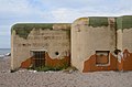
Polski: Ośrodek Oporu Jastarnia - schron bojowy Sokół, 1939
| Object location | | View all coordinates using: OpenStreetMap |
|---|
 | |||||
| Upload media | |||||
| Part of | |||||
|---|---|---|---|---|---|
| Location | Jastarnia, Powiat pucki, Pomeranian Voivodeship, Poland | ||||
| Heritage designation |
| ||||
| Inception |
| ||||
 | |||||
Media in category "Bunker Sokół"
The following 5 files are in this category, out of 5 total.
-
 Jastarnia Sokol cupola 2022.jpg 4,590 × 3,060; 14.14 MB
-
 Jastarnia, "Sokół" Heavy bunker - panoramio.jpg 2,592 × 1,728; 1.86 MB
-
 Jastarnia, schron bojowy Sokół (WLZ14).jpg 3,775 × 2,500; 3.92 MB
-
 Jastarnia, schron bojowy Sokół.jpg 3,072 × 2,304; 2.1 MB
-
 Sokól bunker Jastarnia Poland July2009.jpg 4,071 × 2,714; 1.98 MB


.jpg)
