Category:Chapelle Saint-Lié de Ville-Dommange
Jump to navigation
Jump to search
| Object location | | View all coordinates using: OpenStreetMap |
|---|
|
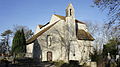
This building is classé au titre des monuments historiques de la France. It is indexed in the base Mérimée, a database of architectural heritage maintained by the French Ministry of Culture, under the reference PA00078894
|
chapel located in Marne, in France  | |||||
| Upload media | |||||
| Instance of | |||||
|---|---|---|---|---|---|
| Location | Ville-Dommange, canton of Ville-en-Tardenois | ||||
| Street address |
| ||||
| Heritage designation |
| ||||
 | |||||
Media in category "Chapelle Saint-Lié de Ville-Dommange"
The following 6 files are in this category, out of 6 total.
-
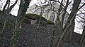
 Bunker 6686.JPG 4,592 × 2,576; 3.88 MB
-
 Chapelle XII cimetière Villedommange.jpg 4,592 × 2,576; 699 KB
-
 Chapelle XII Villedommange.jpg 4,592 × 2,576; 726 KB
-
 Face ouest 6684.JPG 4,592 × 2,576; 6.47 MB
-
 Vers sud 6693.JPG 4,592 × 2,576; 6.31 MB
-
 Vers sud ouest 6694.JPG 4,592 × 2,576; 6.63 MB


