Category:Cheshire, Massachusetts
둘러보기로 이동
검색으로 이동
town in Berkshire County, Massachusetts, United States   | |||||
| 미디어 올리기 | |||||
| 다음 종류에 속함 | |||||
|---|---|---|---|---|---|
| 다음의 한 부분임 |
| ||||
| 위치 | 버크셔군, 매사추세츠주, 미국 | ||||
| 만들어진 날 |
| ||||
| 인구수 |
| ||||
| 면적 |
| ||||
| 해발고도 |
| ||||
 | |||||
하위 분류
다음은 이 분류에 속하는 하위 분류 5개 가운데 5개입니다.
"Cheshire, Massachusetts" 분류에 속하는 미디어
다음은 이 분류에 속하는 파일 16개 가운데 16개입니다.
-
 Ashuwillticook Rail Trail entering Cheshire, Cheshire MA.jpg 4,032 × 3,024; 7.28 MB
-
 Ashuwillticook Rail Trail, Lanesborough and Cheshire MA.jpg 2,592 × 1,728; 1.21 MB
-
-

-
 Berkshire Street Railway and North Adams Branch at Cheshire Harbor - 1908 postcard.jpg 1,600 × 1,009; 317 KB
-
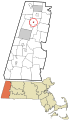
 Cheshire ma highlight.png 788 × 466; 54 KB
-
 Cheshire Reservoir, Ashuwillticook Rail Trail, Cheshire MA.jpg 4,032 × 3,024; 3.93 MB
-
 Cheshire Reservoir, MA.jpg 2,592 × 1,728; 560 KB
-
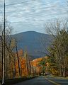 Cheshire-Greylock.jpg 640 × 800; 100 KB
-
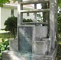 Chesire Cheese Monument Chesire MA USA Sep 2012.jpg 1,229 × 1,199; 314 KB
-
 Corner of Lanesborough and Farnam Roads, Cheshire MA.jpg 3,072 × 2,304; 2.78 MB
-
 Halls Tavern, Cheshire, Massachusetts.jpg 2,048 × 1,536; 850 KB
-
 Hoosac Valley Middle and High School, Cheshire MA.jpg 5,472 × 3,648; 5.46 MB
-
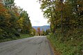 MA Route 116 entering Cheshire MA.jpg 2,592 × 1,728; 1.02 MB
-
 Road to Cheshire, Pittsfield, Mass (NYPL b12647398-75751).tiff 2,368 × 1,590; 10.78 MB
-
 W, Ashuwillticook Rail Trail, Cheshire MA.jpg 4,032 × 3,024; 6.08 MB


_highlighted.svg)


