Category:Cimetière de Cocherel
Jump to navigation
Jump to search
| Object location | | View all coordinates using: OpenStreetMap |
|---|
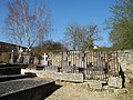
cemetery located in Eure, in France  | |||||
| Upload media | |||||
| Instance of | |||||
|---|---|---|---|---|---|
| Location | Houlbec-Cocherel, canton of Vernon-Sud | ||||
| Adjacent building | |||||
 | |||||
Media in category "Cimetière de Cocherel"
The following 4 files are in this category, out of 4 total.
-
 Cimetiere cocherel côté église.JPG 3,648 × 2,736; 2.12 MB
-
 Cimetière cocherel côté tombe de Briand.JPG 3,648 × 2,736; 2.18 MB
-
 Sepulture de Cocherel cropped.jpg 161 × 216; 50 KB
-
 Sepulture de Cocherel.JPG 656 × 471; 103 KB


